The University of Tulsa
Mountain Cedar Pollen Forecast

Metropolitan Area |
Exposure Risk |
|
Oklahoma City |
Low |
|
Tulsa |
Low |
|
St. Louis MO |
Low |
Date Issued: 31 December 2012
Mountain Cedar Location(s): Arbuckle Mountains, OK
Regional Weather: Monday, December 31 TX/OK:
Across the region the weather continues to be seasonally mild with high temperatures to the north climbing into
the 40s and across Texas temperatures in the 60s today. A dominant south to southeasterly flow will build moisture
over the region today and tonight with most areas expecting rain, showers, and thunderstorms into this evening.
Rain is expected across the region with those areas of western most Texas beginning to dry out this afternoon
and into tonight. The remainder of the area will have the chance of snow in Oklahoma and rain southward into the
east central and eastern portions of Texas tonight. In Oklahoma today temperatures will struggle to get into the
low 40s and then return back into the 30s tonight. Across Texas warmer conditions will be on tap with the dominant
south to southeasterly flow. High temperatures today will be in the 60s with lite to moderate winds in most areas.
The one exception will be the western Edwards Plateau region where strong winds will occur as the southwesterly
winds are replaced by a northwesterly flow. Tonight across Texas will see lows in the 50s in the communities
surrounding the Edwards Plateau. On the Plateau itself, temperatures will drop into the upper 30s. Winds across
the region will switch to coming from the north and northwest at moderate to lite levels. Tomorrow the chance
of showers remains to the north in Oklahoma and in the edge communities of Austin and San Antonio. Temperatures
will cool with highs in the 30s and 40s to the north, in the 40s and 50s across the Plateau, and in the 50s
to 60s in the surrounding communities. Skies overall will be mostly to partly cloudy. Winds will be moderate
from the north. Tomorrow night colder temperatures will move in on the northerly winds. Temeperatures are expected
in the 20s to the north and on the Plateau. The surrounding communities of Austin and San Antonio area expected
to drop into the upper 30s to low 40s.
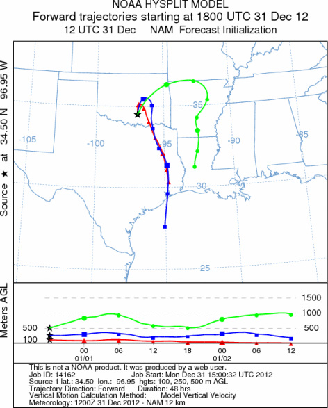
Trajectory weather: Air mass trajectories over the Arbuckle Mountains move northward briefly today then
are overtaken by the wind change, switching from a southerly flow to a northwesterly flow, and moving southward.
The ground conditions will be cool with high temperatures only reaching the low to mid 40s today and into the
mid 30s tonight. Throughout the day there will be a chance of showers and rain. Tonight a 30% chance of drizzle
will take over then a 30% chance of rain returns tomorrow. Winds will remain from the north throughout the remainder
of the forecast after they turn coming from the north and northwest. Poor conditions for pollen release will occur
today with the chance of region wide rain. With all of the moisture in the area any pollen released should be
washed out of the air. Similar conditions will exist for tonight and portions of tomorrow. Cold temperatures
are expected to return tomorrow night with readings in the low 20s.
OUTLOOK: *** Low threat today and Low threat tomorrow *** Poor conditions for
pollen release today with temperatures just into the mid 40s. Tomorrow temperatures will be in the low 40s.
Significant chances of rain will occur today into tonight and tomorrow The moisture will wash out any pollen entrained.
For these reasons there will be poor conditions for entrainment and travel across the region today, tonight, and
tomorrow. Temperatures will mostly be in the 30s and 40s today and tonight with moderate wind speeds. Moderate
winds will build again tomorrow along with the return of humidity and rain. We are approaching the heart of the
historic pollination season. We continue to have patients contacting the modeling team to report strong allergy
symptoms. Today and tomorrow should provide a nice break for allergy sufferers, but once the region dries out
the remaining pollination season will return.
Trajectory Start (s) (shown by black
star on map): Davis, OK.
Prepared by: Estelle
Levetin
(Faculty
of Biological Science, The University of Tulsa, 800 S. Tucker Dr., Tulsa, OK 74104) and Peter
K Van de Water
(Department of Earth and Environmental Science, California State University Fresno, 2576 East San Ramon Avenue,
M/S ST24, Fresno CA 93740-8039). This forecast gives the anticipated future track of released Mountain Cedar pollen,
weather conditions over the region and along the forecast pathway, and an estimated time of arrival for various
metropolitan areas.
Questions: Aerobiology Lab e-mail: pollen@utulsa.edu
Return to Forecasting Home Page