
The University of Tulsa
Mountain Cedar Pollen Forecast
Metropolitan Area |
Exposure Risk |
|
Dallas/Fort Worth |
Low |
|
Austin |
Low |
|
San Antonio |
Low |
Date Issued: 21 December 2013
Mountain Cedar Location(s): Edwards Plateau, Texas
Regional Weather: Saturday/Sunday, December 21/22 TX/OK:
Across the region the weather will be wet today with continuing showers this morning but moving out of the region
this afternoon. To the north in Oklahoma cold conditions will remain with the chance of freezing rain across north
and central Oklahoma, southward towards the border with Texas. In Texas rain and thunderstorms will move across
the region this morning and then start to taper off towards the afternoon. The chance of showers will continue
along the eastern boundary of the Edwards Plateau. To the south and west showers will end mid-morning to early
afternoon and start to clear. Cold conditions will continue across Oklahoma and across northern Texas. The eastern
edge of the Edwards Plateau will be in the mid 70s today and mid to low 60s to the west on the Plateau. Winds
in these areas will be from the southwest to begin the day at light levels. This afternoon strong southwesterly
winds will build tapering off into the evening. Temperatures across the Edwards Plateau will be in the 20s to
the west and low 30s in the eastern edge communities. To the north mid 30s will occur in Dallas and below freezing
conditions northward into Oklahoma. Tomorrow conditions will begin to improve with the skies clearing in most
areas and little chance of precipitation across the entire region. In Texas high temperatures will be in the 40s
and 50s across the Plateau and into the 60s in the surrounding communities. In Oklahoma temperatures will be closer
to freezing with highs reaching into the low 30s and low 40s in the south. Winds will be moderately light from
the north and northwest. Across the region tomorrow night temperatures will fall into the 20s and low 30s with
the western side of the Plateau and areas to the north being the coldest.
Trajectory weather: Air mass trajectories over the Edwards Plateau move north-northeast
today on southwesterly winds as a cold front moves southward over the region the next couple of days. Winds will
remain begin today from the south at 10 to 15 miles per hour, then build to 15 to 25 mph as the cold front moves
in. At that time winds will become stronger with the change of weather systems but then will switch overnight
to a northwesterly direction and calm back to lower levels with the colder atmosphere. The trajectories will flow
northeasterly and the atmosphere will be quite buoyant as the the front passes. The characteristics of the atmosphere,
buoyant and rising, can entrain and carry pollen long distances. However see the outlook below.
OUTLOOK: *** Low Threat Today and Low Threat Tomorrow *** Poor conditions
today and Moderate conditions for pollen release tomorrow in most of the populations areas. There is good conditions
for entrainment and transport as the cold front drops southward across the region. This should occur by tomorrow
in most areas. Tomorrow winds will drop in strength and colder conditions will prevail, but high temperatures
will still be in the 40's and 50's so pollen release may be greater than today. However, with that being said
the season of pollen release from Juniperus ashei is just beginning with little indication of pollen in the atmosphere.
Therefore there may be limited amounts of pollen ready to be shed and no clear indication of moderate or heavy
release across the area. A recent canvas of the trees across Texas showed that the cones are getting ready to
shed pollen, and that there are significant cones on the trees, but they remain unripe in most areas. .
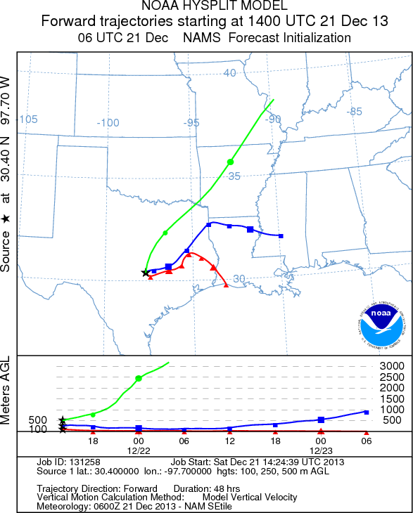
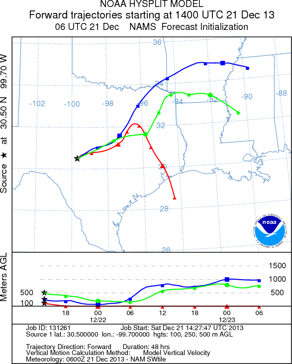
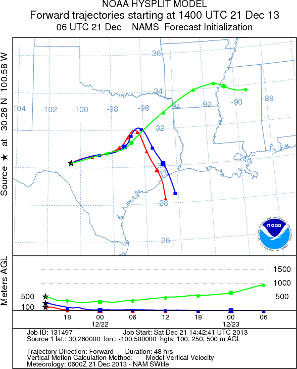
Trajectory Start (s) (shown by *
on map): Austin, TX; Junction, TX; Sonora, TX.
AUSTIN
JUNCTION
SONORA
EDWARDS PLATEAU COMPOSITE
Prepared by: Estelle
Levetin (Faculty of Biological
Science, The
University of Tulsa, 800 S. Tucker Dr., Tulsa, OK 74104) and ) and Peter
K Van de Water (Department of Earth and Environmental Science, California State University Fresno,
2576 East San Ramon Avenue, M/S ST24, Fresno CA 93740-8039). This forecast gives the anticipated future track of
released Mountain Cedar pollen, weather conditions over the region and along the forecast pathway, and an estimated
time of arrival for various metropolitan areas.
Questions: Aerobiology Lab e-mail: pollen@utulsa.edu
Return to Forecasting Home Page