The University of Tulsa
Mountain Cedar Pollen Forecast

Metropolitan Area |
Exposure Risk |
|
Oklahoma City |
Low to Moderate |
|
Tulsa |
Low |
|
St. Louis MO |
Low |
Date Issued: 28 December 2013
Mountain Cedar Location(s): Arbuckle Mountains, OK
Regional Weather: Saturday/Sunday, December 28/29 TX/OK:
Across the region today the weather will be mostly sunny to the north and mostly cloudy to the south. The cloudy
skies will break up to partly cloudy conditions during the afternoon. Temperatures across the region will strive
to get into the 60s with those areas on the Edwards Plateau reaching the upper 50s. Winds will be light from the
south in Oklahoma and northern Texas, and from the southwest across the Edwards Plateau and in the communities
surrounding the Plateau. Tonight, the skies will become partly cloudy with a chance of fog in the areas surrounding
the Edwards Plateau and north into the Dallas/Ft. Worth area. Low temperatures will be in the lower 40s in San
Antonio, Austin and north into the Dallas/Ft. Worth area. In Oklahoma lows will drop into the mid 20s north and
low 30s along the border. Similar 30 degree readings will occur across the Edwards Plateau towards the west.
Tomorrow, mostly cloudy to partly cloudy conditions will predominate. More sun than clouds are expected in northern
Texas south into the communities surrounding the Edwards Plateau. These areas will see patchy morning fog as well.
High temperatures will cool with most areas on the Edwards Plateau reaching only into the 40s. Warmer air will
work itself into the surrounding communities with San Antonio and Austin hovering in the upper 50s to low 60s,
and then back to the 40s to the north dropping into the 30s in Oklahoma. Winds will begin to pick-up Sunday afternoon
with moderate conditions across the region. Many areas will see gusts of 20 to 25 miles per hour. Tomorrow night
colder conditions will prevail with most areas reaching below freezing. The Plateau and Oklahoma region will be
well below freezing bottoming out in the 20s. Winds will be from the north at moderate levels.
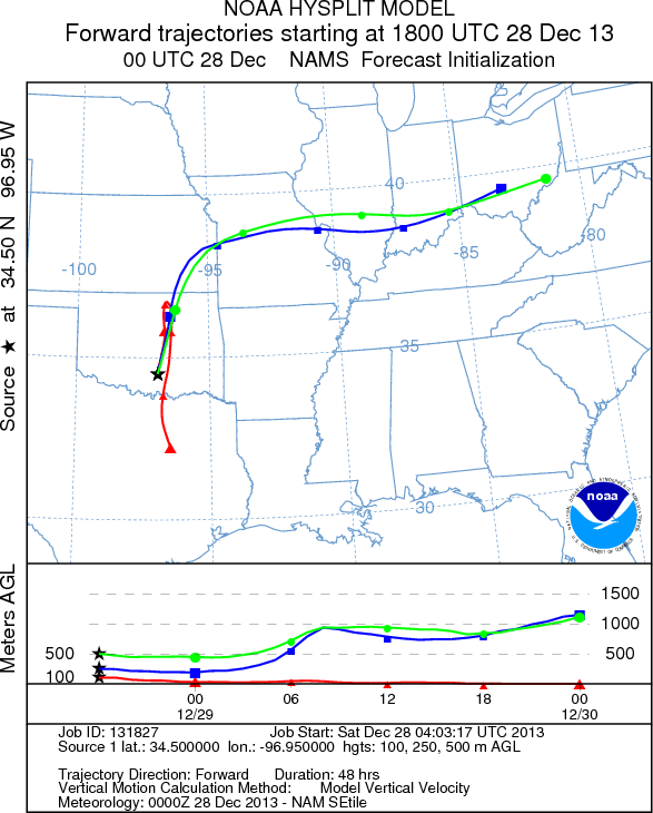
Trajectory weather: Air mass trajectories over Southern Oklahoma move slowly northward on the dominant southwesterly
winds today. The winds will be light to moderate thus the trajectories move northward across the central portion
of Oklahoma. Once the trajectories reach northern Oklahoma the lower portion of the atmosphere will turn southward
as a push of cold dense air begins to drive southward. At the upper portion of the trajectories will be caught
in more buoyant conditions and continue north and then eastward. Temperatures will build into the 60s across the
state with mostly sunny skies. Overnight temperatures will drop into the 20s and low 30s southward in the border
region with Texas. Tomorrow temperatures will struggle to get to 40 degrees. Skies will be cloudy and there is
a chance of drizzle or light rain in the area. Winds will be stronger at 15 to 25 mph, but the cold conditions
and potential rain will restrict any pollen release. Tomorrow night temperatures will drop into the teens and
winds will remain from the north at 10 to 20 mph.
OUTLOOK: *** Moderate Threat Today and Low Threat Tomorrow
*** Better conditions for pollen release today than tomorrow in most of the populations in southern Oklahoma.
Today light winds and dense air will affect any pollen release, with poor conditions for entrainment and travel.
Pollen may be in the atmosphere, however large amounts are not expected and long distance transport will be minimal.
Temperatures will be warming into the 60s in many areas and 50s across the Edwards Plateau today. Tomorrow, a
cold front will move south bringing a more turbulent atmosphere but with colder conditions during the day. The
turbulent change has the potential to liberate pollen from the cones although with the colder air and moisture
winds will move near ground level and either settle out or be impacted on nearby obstructions. To the south early
signs suggest that the trees are beginning to release pollen. But with mixed conditions, communities in Texas
to central Oklahoma may expect to see some pollen in the atmosphere soon, but heavy accumulations are not forecast
in the near future. A recent canvas of the trees across Texas showed significant numbers of cones are ready to
shed pollen, with warm conditions the chance of pollen in the atmosphere continues to rise.
Trajectory Start (s) (shown by black
star on map): Davis, OK.
Prepared by: Estelle
Levetin
(Faculty
of Biological Science, The University of Tulsa, 800 S. Tucker Dr., Tulsa, OK 74104) and Peter
K Van de Water
(Department of Earth and Environmental Science, California State University Fresno, 2576 East San Ramon Avenue,
M/S ST24, Fresno CA 93740-8039). This forecast gives the anticipated future track of released Mountain Cedar pollen,
weather conditions over the region and along the forecast pathway, and an estimated time of arrival for various
metropolitan areas.
Questions: Aerobiology Lab e-mail: pollen@utulsa.edu
Return to Forecasting Home Page