
The University of Tulsa
Mountain Cedar Pollen Forecast
Metropolitan Area |
Exposure Risk |
|
Dallas/Fort Worth |
Low |
|
Austin |
Low to Moderate |
|
San Antonio |
Low to Moderate |
Date Issued: 28 December 2013
Mountain Cedar Location(s): Edwards Plateau, Texas
Regional Weather: Saturday/Sunday, December 28/29 TX/OK:
Across the region today the weather will be mostly sunny to the north and mostly cloudy to the south. The cloudy
skies will break up to partly cloudy conditions during the afternoon. Temperatures across the region will strive
to get into the 60s with those areas on the Edwards Plateau reaching the upper 50s. Winds will be light from the
south in Oklahoma and northern Texas, and from the southwest across the Edwards Plateau and in the communities
surrounding the Plateau. Tonight, the skies will become partly cloudy with a chance of fog in the areas surrounding
the Edwards Plateau and north into the Dallas/Ft. Worth area. Low temperatures will be in the lower 40s in San
Antonio, Austin and north into the Dallas/Ft. Worth area. In Oklahoma lows will drop into the mid 20s north and
low 30s along the border. Similar 30 degree readings will occur across the Edwards Plateau towards the west.
Tomorrow, mostly cloudy to partly cloudy conditions will predominate. More sun than clouds are expected in northern
Texas south into the communities surrounding the Edwards Plateau. These areas will see patchy morning fog as well.
High temperatures will cool with most areas on the Edwards Plateau reaching only into the 40s. Warmer air will
work itself into the surrounding communities with San Antonio and Austin hovering in the upper 50s to low 60s,
and then back to the 40s to the north dropping into the 30s in Oklahoma. Winds will begin to pick-up Sunday afternoon
with moderate conditions across the region. Many areas will see gusts of 20 to 25 miles per hour. Tomorrow night
colder conditions will prevail with most areas reaching below freezing. The Plateau and Oklahoma region will be
well below freezing bottoming out in the 20s. Winds will be from the north at moderate levels.
Trajectory weather: Air mass trajectories over the Edwards Plateau move slowly northward on the dominant
southwesterly winds. The winds will be light thus the trajectories move slowly across Texas today. Temperatures
will build into the 60s in north Texas and in the communities surrounding the Edwards Plateau. On the Plateau
itself the highs will get into the upper 50s. Tonight the winds will calm and temperatures will be in the 40s
except on the Plateau where they will drop into the 30s. Tomorrow, the skies will clear over the eastern and northern
areas. In Austin north towards Dallas/Ft. Worth morning fog is expected. Winds will have switched overnight bringing
colder air southward. High temperatures will be in the 40s across the Edwards Plateau, and eventually move into
the surrounding edge communities. Winds will pick up as this cold mass of air moves southward, with afternoon
winds increasing to 15 to 20 mph in some areas. Tomorrow night partly cloudy skies will dominate and temperatures
will hover near freezing in the warmest areas. The Plateau will be well into the lower 20s. Conditions for pollen
release will be at their best Saturday afternoon. At that time light winds will still occur over most of the area
thus if pollen is shed the potential for long distance transport is not particularly good.
OUTLOOK: *** Moderate Threat Today and Tomorrow *** Better conditions for pollen
release today than tomorrow in most of the populations. Today light winds and dense air will affect any pollen
release, with poor conditions for entrainment and travel. Pollen may be in the atmosphere, however large amounts
are not expected and long distance transport will be minimal. Temperatures will be warming into the 60s in many
areas and 50s across the Edwards Plateau today. Tomorrow, a cold front will move south bringing a more turbulent
atmosphere but with colder conditions during the day. The turbulent change over has the potential to liberate
pollen from the cones although with the colder air most will move near ground level and either settle out or be
impacted on nearby obstructions. That being said, the past couple of days pollen has been recorded at increasing
levels in San Antonio but initial increases in Austin, and Waco have not been sustained. This suggests that the
trees are beginning to release pollen. But with mixed conditions, communities in Texas to central Oklahoma may
see some pollen in the atmosphere, but not heavy accumulations. A recent canvas of the trees across Texas showed
significant numbers of cones are ready to shed pollen, with warm conditions the chance of pollen in the atmosphere
continues to rise.
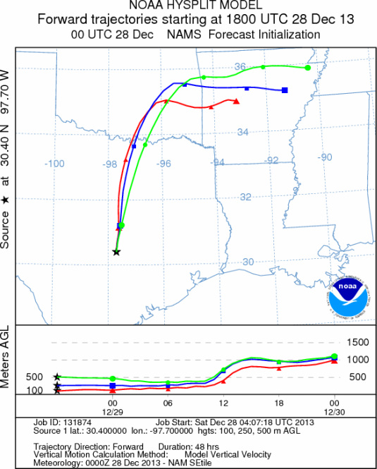
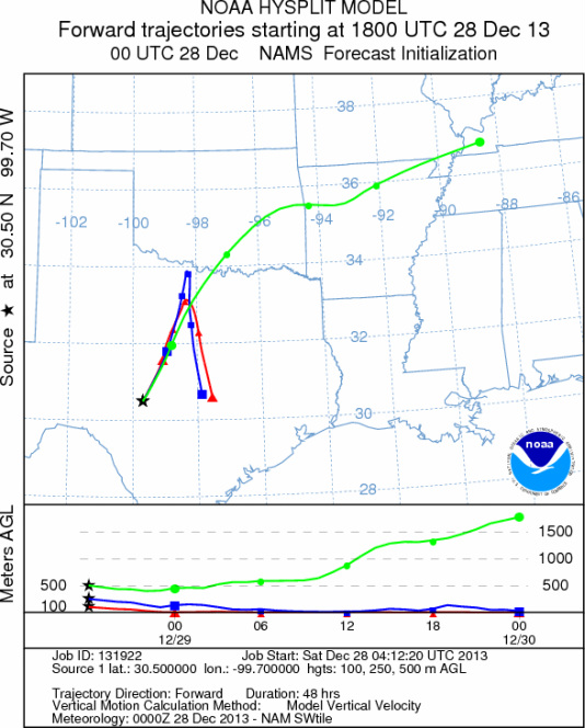
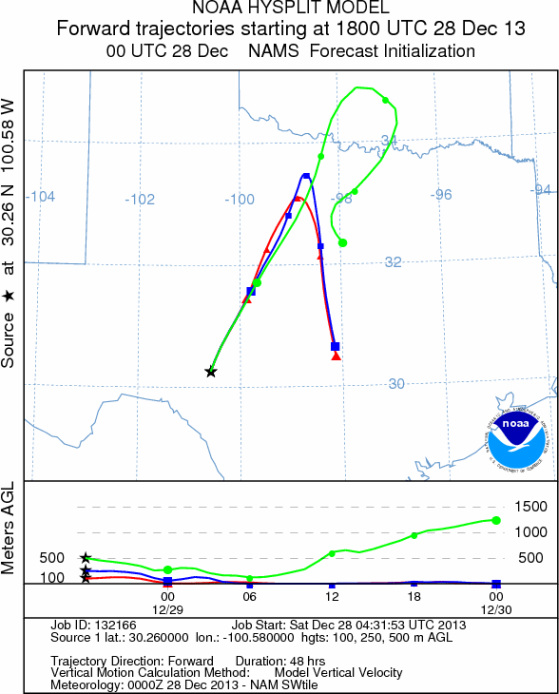
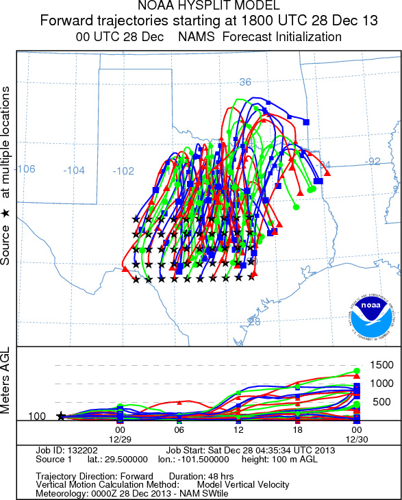
Trajectory Start (s) (shown by *
on map): Austin, TX; Junction, TX; Sonora, TX.
AUSTIN
JUNCTION
SONORA
EDWARDS PLATEAU COMPOSITE
Prepared by: Estelle
Levetin (Faculty of Biological
Science, The
University of Tulsa, 800 S. Tucker Dr., Tulsa, OK 74104) and ) and Peter
K Van de Water (Department of Earth and Environmental Science, California State University Fresno,
2576 East San Ramon Avenue, M/S ST24, Fresno CA 93740-8039). This forecast gives the anticipated future track of
released Mountain Cedar pollen, weather conditions over the region and along the forecast pathway, and an estimated
time of arrival for various metropolitan areas.
Questions: Aerobiology Lab e-mail: pollen@utulsa.edu
Return to Forecasting Home Page