The University of Tulsa
Mountain Cedar Pollen Forecast

Metropolitan Area |
Exposure Risk |
|
Oklahoma City |
Moderate |
|
Tulsa |
Low |
|
St. Louis MO |
Low |
Date Issued: 31 December 2013
Mountain Cedar Location(s): Arbuckle Mountains, OK
Regional Weather: Tuesday, December 31/ Wednesday, January
1 TX/OK: Across the region today and tomorrow the weather will be mild with mostly sunny to sunny skies.
Temperatures will be mild with highs expected in the 50s region wide. The Edwards Plateau will be in the upper
50s whereas the remaining areas will reach into the mid 50s. This includes the southern Oklahoma region as well.
Oklahoma City is expected to rise into the lower 50s. Winds will be generally light and variable except on the
Edwards Plateau. Across that region winds from the south will begin to build. Tonight mostly clear skies will
remain across the region. Lows will be in the 30s, low 30s across the Edwards Plateau and north into Oklahoma,
the remaining areas will be in the upper 30s. Tomorrow morning mostly cloudy conditions will develop along the
eastern edge of the Edwards Plateau and north into Oklahoma. These conditions will clear to mostly sunny conditions
across Texas. High Temperatures will reach into the low 60s warming towards the west. Winds will be stronger,
10-15 mph from the southwest region wide. New Years evening mostly clear conditions will prevail over the Edwards
Plateau and north towards Dallas. In the communities surrounding the Edwards Plateau partly cloudy skies will
build in with the chance of patchy fog. Temperatures across Texas will remain in the 30s mostly above freezing.
To the north a change in winds with the southerly air being replaced by a northerly flow will drop temperatures
into the teens. Overnight across Texas the same switch in air movement will occur with the southwesterly winds
being replaced by colder northerly breezes at at 10-15 miles per hour. Many of the communities surrounding the
Edwards Plateau will experience gusty conditions.
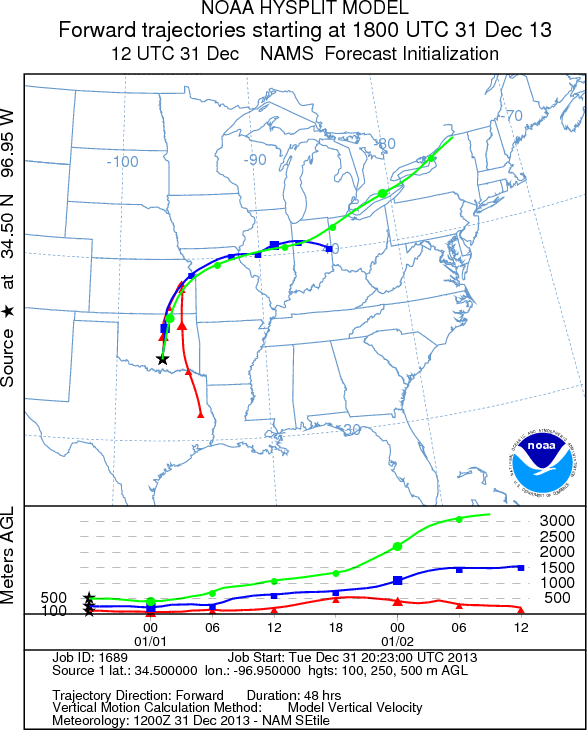
Trajectory weather: Air mass trajectories over southern Oklahoma move slowly northward today, then increasing
in strength tonight. Winds will be from the south today, tonight and tomorrow during the day. Tomorrow night
winds will switch coming from the north and increase to moderate wind speeds. Temperatures will warm into the
50s today and tomorrow with slight warmer conditions. The next cold front will start to arrive in Oklahoma City
tomorrow afternoon working its way southward into tomorrow evening. As the front moves southward the dominant
southerly breezes blowing today will give way to stronger winds coming from the north. Conditions across the region
will be good for pollen release today and tomorrow. To the south along the edge of the Edwards Plateau, high levels
of pollen have been reported in San Antonio, Austin as well as Waco. Today and tomorrow will be very good conditions
for the Arbuckle Mountain population to begin to release its pollen. The atmosphere, however, will be only moderately
conditioned for entrainment and travel. Winds will be light and overall movement will be relatively localized
at ground level.
OUTLOOK : *** High Threat Today and High Threat Tomorrow *** Good conditions for
pollen release today and tomorrow in the populations in southern Oklahoma. Today light winds will occur but warming
conditions will promote pollen release in the afternoon after a very cold start this morning. However, conditions
for entrainment and travel will be moderate with light winds and a dense atmosphere. Over the past couple of days,
large amounts of pollen have been recorded in the communities surrounding the Edwards Plateau suggesting that the
pollen has begun to be released. However, the reporting station in Dallas has not recorded any significant amounts
indicating that the populations to the north continue to ripen. Tomorrow, conditions will be even better with temperatures
getting close to the 60s in most areas. The communities affected will be in the region around the Arbuckle Mountains
as far north as Oklahoma City. Beyond that there is little expectation of long distance transport because of relatively
dense air at the surface moving any entrained pollen near the ground surface where impaction occurs. As the day
goes on tomorrow, north winds will begin to encroach pushing any entrained pollen souuthward towards north Texas.
This may be the first cedar pollen in their atmosphere over the north Texas region this season. s
Trajectory Start (s) (shown by black
star on map): Davis, OK
.
Prepared by: Estelle
Levetin
(Faculty
of Biological Science, The University of Tulsa, 800 S. Tucker Dr., Tulsa, OK 74104) and Peter
K Van de Water
(Department of Earth and Environmental Science, California State University Fresno, 2576 East San Ramon Avenue,
M/S ST24, Fresno CA 93740-8039). This forecast gives the anticipated future track of released Mountain Cedar pollen,
weather conditions over the region and along the forecast pathway, and an estimated time of arrival for various
metropolitan areas.
Questions: Aerobiology Lab e-mail: pollen@utulsa.edu
Return to Forecasting Home Page