
The University of Tulsa
Mountain Cedar Pollen Forecast
Metropolitan Area |
Exposure Risk |
|
Dallas/Fort Worth |
Moderate |
|
Austin |
High |
|
San Antonio |
High |
Date Issued: 31 December 2013
Mountain Cedar Location(s): Edwards Plateau, Texas
Regional Weather: Tuesday, December 31/ Wednesday, January
1 TX/OK: Across the region today and tomorrow the weather will be mild with mostly sunny to sunny skies.
Temperatures will be mild with highs expected in the 50s region wide. The Edwards Plateau will be in the upper
50s whereas the remaining areas will reach into the mid 50s. This includes the southern Oklahoma region as well.
Oklahoma City is expected to rise into the lower 50s. Winds will be generally light and variable except on the
Edwards Plateau. Across that region winds from the south will begin to build. Tonight mostly clear skies will
remain across the region. Lows will be in the 30s, low 30s across the Edwards Plateau and north into Oklahoma,
the remaining areas will be in the upper 30s. Tomorrow morning mostly cloudy conditions will develop along the
eastern edge of the Edwards Plateau and north into Oklahoma. These conditions will clear to mostly sunny conditions
across Texas. High Temperatures will reach into the low 60s warming towards the west. Winds will be stronger,
10-15 mph from the southwest region wide. New Years evening mostly clear conditions will prevail over the Edwards
Plateau and north towards Dallas. In the communities surrounding the Edwards Plateau partly cloudy skies will
build in with the chance of patchy fog. Temperatures across Texas will remain in the 30s mostly above freezing.
To the north a change in winds with the southerly air being replaced by a northerly flow will drop temperatures
into the teens. Overnight across Texas the same switch in air movement will occur with the southwesterly winds
being replaced by colder northerly breezes at at 10-15 miles per hour. Many of the communities surrounding the
Edwards Plateau will experience gusty conditions.
Trajectory weather: Air mass trajectories over the Edwards Plateau move slowly north today and tomorrow
and then curve back around tomorrow night. In most regions the winds will be light except for the Dallas area
and the westernmost portions of the Edwards Plateau. Trajectory analysis suggests that the ground level winds
will move slowly enough to remain within the Texas borders from the western side of the plateau. The air appears
to be dense and thus most ground level winds will remain near the surface. Tomorrow temperatures will be warming
into the 60s and the southwesterly winds will increase to 10 to 15 miles per hour. Overnight temperatures will
be in the 30s across Texas. Winds will be switching from the dominant southwesterly direction to a dominant northerly
direction beginning tomorrow night. This will bring the trajectories back southward. As the winds switch there
is potential to move any pollen entrained in the atmosphere some distance.
OUTLOOK: *** High Threat Today and Tomorrow *** Excellent conditions for pollen
release today and tomorrow in most of the populations across Texas. Today light winds will occur but warming conditions
will promote pollen release, especially in the communities surrounding the Edwards Plateau. However, conditions
for entrainment and travel will be moderate with light winds and a dense atmosphere. Over the past couple of days,
large amounts of pollen have been recorded in the communities surrounding the Edwards Plateau suggesting that the
pollen has begun to be released. Tomorrow, conditions will be even better with temperatures warming into the 60s
in most areas. The communities affected will be in and around central Texas with little expectation of long distance
transport. As the winds begin to switch again on New Years night communities toward south Texas may get their
first levels of pollen in their atmosphere.
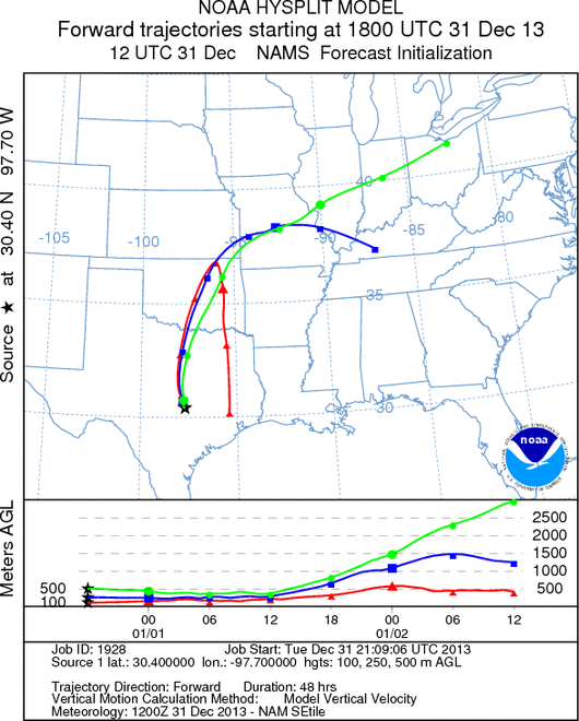
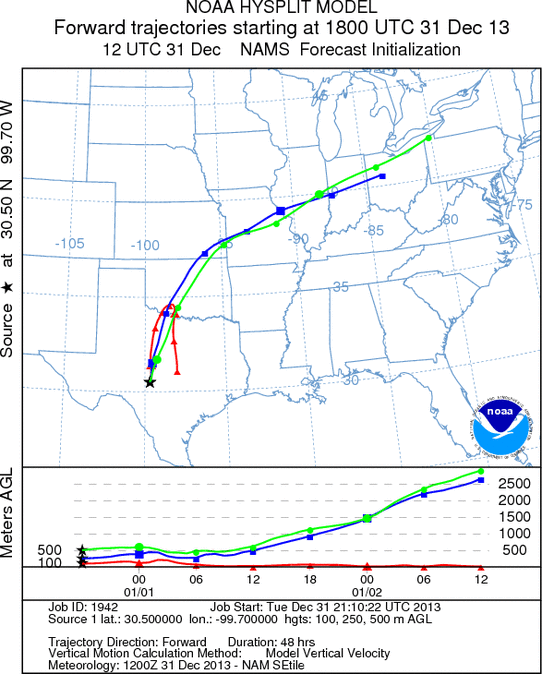
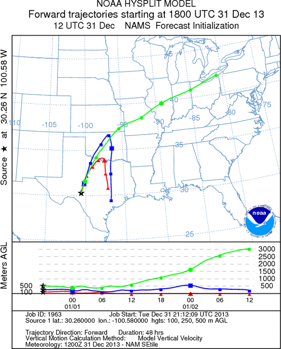
Trajectory Start (s) (shown by *
on map): Austin, TX; Junction, TX; Sonora, TX.
AUSTIN
JUNCTION
SONORA
EDWARDS PLATEAU COMPOSITE
Prepared by: Estelle
Levetin (Faculty of Biological
Science, The
University of Tulsa, 800 S. Tucker Dr., Tulsa, OK 74104) and ) and Peter
K Van de Water (Department of Earth and Environmental Science, California State University Fresno,
2576 East San Ramon Avenue, M/S ST24, Fresno CA 93740-8039). This forecast gives the anticipated future track of
released Mountain Cedar pollen, weather conditions over the region and along the forecast pathway, and an estimated
time of arrival for various metropolitan areas.
Questions: Aerobiology Lab e-mail: pollen@utulsa.edu
Return to Forecasting Home Page