The University of Tulsa
Mountain Cedar Pollen Forecast

Metropolitan Area |
Exposure Risk |
|
Oklahoma City |
Low |
|
Tulsa |
Low |
|
St. Louis MO |
Low |
Date
Issued: 17 December 2014
Mountain
Cedar Location(s): Arbuckle Mountains, OK
Regional
Weather: Wednesday, December 17 – TX/OK: Across the region today
skies will be cloudy with an overall flow from the south and east moving air
northwards. Winds will be in the 5 to 10 miles per hour range and showers
are expected. There will be a 50% chance of precipitation developing on
the Plateau with only a 20% chance to the southwest. Temperatures across
the Edwards Plateau will be in the 50s. To the north in Dallas and
towards Oklahoma highs will be in the 40s. The chance of rain will be
greater to the north with the border area around Ardmore expecting a 70% chance
of rain. Cloudy skies will remain across the region tonight and
throughout tomorrow. The chance of rain will continue throughout the
evening with mild temperatures. Lows will generally be within 10 degrees
of today’s high. Readings in the mid to upper 40s and low 50s will be the
norm overnight. Tomorrow the clouds will remain, but the chance of rain
will diminish with most areas having only a 20% chance. The communities
around the edge of the Edwards Plateau should expect fog and warming during the
daytime. Highs on Thursday will be in the middle 60s with light winds
from the south to southeast. In north Texas and across southern Oklahoma
similar conditions will occur but with temperatures only reaching into the
upper 40s and low 50s. Thursday night the chance of rain returns with the
region having a 50% to 60% across Texas and a 20% chance across central and
southern Oklahoma. The preceding dominant southerly wind flow will give
way to northeasterly winds, bringing slightly cooler air into the region.
Temperatures over the Plateau will be in the 40s with the edge communities
remaining in the low 50s. North Texas and southern Oklahoma will be in
the 30s. Wednesday, December 17
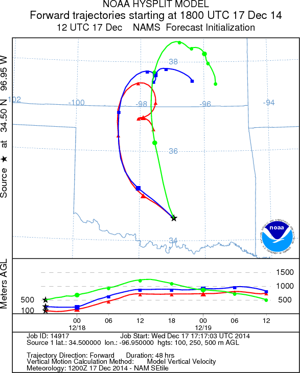
Trajectory weather: Air mass trajectories over southern Oklahoma move to
the north, on south to southeasterly winds today, tonight and then curve back
around to the south. Temperatures will be in the 30s and 40s today and
40s tomorrow. Tonight and tomorrow night temperatures will drop into the
mid to upper 30s. Throughout the period a chance of rain is in the
forecast. Today there is a 70% chance of showers over the region,
declining to 50% tonight. Tomorrow the chance of precipitation drops to
20% throughout the day and into the evening.
OUTLOOK: *** Poor to Moderate Threat Today and
Moderate Threat Tomorrow *** Poor to moderate conditions for pollen release today and
tomorrow in the Arbuckle population because the chance of rain will occur during
the forecast period. Yesterday’s regional
pollen levels along with discovery of cones shedding pollen in the Arbuckle
Mountains show that the trees are ready for dispersal. The overall
conditions will be decline today with a greater than 50% chance rain today, but
during dryer periods, release, entrainment and dispersal are possible.
Tomorrow, conditions will improve with a declining chance of precipitation,
temperatures in the 40s and light winds.
Trajectory Start (s)
(shown by black star
on map): Davis, OK
Prepared by: Estelle Levetin (Faculty
of Biological Science, The University of Tulsa, 800 S. Tucker Dr.,
Tulsa, OK 74104) and Peter
K Van de Water
(Department of Earth and Environmental Science, California State
University Fresno, 2576 East San Ramon Avenue, M/S ST24, Fresno CA
93740-8039). This forecast gives the anticipated future track of
released Mountain Cedar pollen, weather conditions over the region and
along the forecast pathway, and an estimated time of arrival for
various metropolitan areas.
Questions: Aerobiology Lab e-mail: pollen@utulsa.edu