The University of Tulsa
Mountain Cedar Pollen Forecast

Metropolitan Area |
Exposure Risk |
|
Oklahoma City |
Low |
|
Tulsa |
Low |
|
St. Louis MO |
Low |
Date
Issued: 18 December 2014
Mountain
Cedar Location(s): Arbuckle Mountains, OK
Regional
Weather: Thursday, December 18
– TX/OK: Across the region today skies will be mostly cloudy with a
light flow from across the region. To the north in Oklahoma winds will be
light and variable, whereas in the communities along the edge of the Edwards
Plateau a light northeasterly flow will occur. On the Plateau itself
winds will be from the west. Temperatures across Texas today will be in
the mid to upper 60s. There is a chance of rain and fog this morning in
the communities along the southern I-35 corridor. To the north in
Oklahoma highs will be in the 40s with a chance of light rain. Overnight
across the region cloudy conditions will build. In southern Oklahoma
there will be a 20% chance of rain and lows in the upper 30s to low 40s.
Across Texas the chance of rain will be much greater with the eastern Edwards
Plateau having a 70% to 90% chance of precipitation. To the west the
chance of rain will diminish. Winds will be from 5 to 10 miles per hour
from the northeast. Tomorrow morning the rains will continue into the
morning with temperatures remaining in the 50s to low 60s across Texas,
and winds in the 5-10 mph range from the north. In southern Oklahoma
there will be a 50% chance of rain and high temperatures staying in the
40s. The northerly flow will continue with winds expected to climb to the
10 mph range. Tomorrow night the system will begin to clear, however
mostly cloudy skies will prevail. The chance of precipitation ends and
lows will drop into the low 40s into the upper 30s. Winds will continue
overnight from the north at 5 to 10 mph.
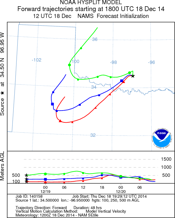
Trajectory weather: Air mass trajectories over southern Oklahoma move to the
south, on light to variable winds from the north. The air trajectories
eventually move into northern Texas where they will be caught up in the overall
mix of variable winds. To the south rains will move in tonight, however
southern Oklahoma has only a 20% chance or precipitation tonight.
Tomorrow the chance of showers will increase to 50%. Tomorrow’s high
temperatures will be in the upper 40s and stronger winds from the north to
northeast will dominate. Tomorrow night clearing will begin with partly
cloudy skies. A 20% chance or precipitation will remain and temperatures
will drop into the lower 30s. Winds will return to light and variable
conditions. Throughout the forecast period the trajectories from southern
Oklahoma will move towards central Texas.
OUTLOOK: ***
Moderate Threat Today and Low to Moderate Threat
Tomorrow *** Moderate conditions for pollen
release today with a slight chance of rain overnight Tomorrow the Arbuckle
population will see a 50% chance of rain. Yesterday’s regional pollen levels along with discovery
of cones shedding pollen in the Arbuckle Mountains show that the trees are
ready for dispersal. The overall conditions will be moderate today but
then worsen with a greater than 50% chance rain. However, during dryer
periods today and tomorrow release, entrainment and dispersal are
possible. Tomorrow night conditions begin to improve as the weather
system moves out of the region.
Trajectory Start (s)
(shown by black star
on map): Davis, OK
Prepared by: Estelle Levetin (Faculty
of Biological Science, The University of Tulsa, 800 S. Tucker Dr.,
Tulsa, OK 74104) and Peter
K Van de Water
(Department of Earth and Environmental Science, California State
University Fresno, 2576 East San Ramon Avenue, M/S ST24, Fresno CA
93740-8039). This forecast gives the anticipated future track of
released Mountain Cedar pollen, weather conditions over the region and
along the forecast pathway, and an estimated time of arrival for
various metropolitan areas.
Questions: Aerobiology Lab e-mail: pollen@utulsa.edu