The University of Tulsa
Mountain Cedar Pollen Forecast

Metropolitan Area |
Exposure Risk |
|
Oklahoma City |
Low |
|
Tulsa |
Low |
|
St. Louis MO |
Low |
Date
Issued: 19 December 2014
Mountain Cedar Location(s): Arbuckle Mountains, OK
Regional
Weather: Friday, December 19 – TX/OK:
Across the region today skies will be cloudy with a moderate flow from the
north to northeast across the region. To the north in Oklahoma winds will
be light and variable.. On the Plateau itself winds will be from the
north to northeast. Temperatures across Texas today will grade from the
mid-40s to the north, 50s across the Edwards Plateau and into the 60s at the
southern edge communities. There will be a chance of showers across the
entire region. In Oklahoma there will be a 20% to 30% chance of rain with
drizzle and foggy conditions. In north Texas the chance of rain increases
to 60% in the Dallas/Ft Worth area. Southward along the I-35 corridor the
chance of rain will climb to 70%. The Edwards Plateau will have a 40%
chance to the west, rising towards the east. By this evening the chance
of showers will have moved off to the east with skies becoming partly cloudy in
most areas. Winds will remain light overnight and from the north to
northeast. Saturday, skies will become partly cloudy with clearing to the
far west. Temperatures will be in the 50s region wide and winds will be
light from the southeast in most areas. Northeasterly winds will remain in
the edge communities along the I-35 corridor. Saturday night partly to
mostly cloudy skies will occur and temperatures will drop into the 30s over the
Plateau and in southern Oklahoma, and be in the mid to low 40s in the edge
communities from Waco to Austin and west to San Antonio.
Trajectory weather: Air mass trajectories over southern Oklahoma will
remain relatively stable not moving much, but overall heading southward over
northern Texas. Temperatures will be cool with most areas in the
40s. This morning will see ground fog with a 20% to 30% chance of showers
developing in conjunction with the rain over the Edwards Plateau. Last
night a front dropped southward across the region bringing with the significant
chance of rain further south. Winds will be light and variable over the
entire forecast period. Saturday afternoon and evening conditions will
improve as Friday’s system moves towards the east. There will be a chance
of pollen being dispersed both days, with the greater chance of precipitation
today it will be less likely than tomorrow. The past few days have shown that
the trees have ripe cones and pollen is being entrained into the
atmosphere. Overall today will have a potential for pollen in the
atmosphere but it will clear as rain develops.
OUTLOOK: *** Moderate Threat Today and Moderate Threat
Tomorrow *** Moderate
conditions for pollen release today with a slight chance of rain today. Tomorrow the Arbuckle population will
see improving conditions and a slight warmup. High temperatures will be in the
mid-40s today and low 50s tomorrow. The cones on trees growing in the
Arbuckle mountain area are shedding pollen and are ready for dispersal.
The overall conditions will be moderate today depending upon whether or not it
rains. If pollen is shed the overall light winds will move entrained
pollen grains to the south over the Texas border towards the Dallas/Ft Worth
region. Tomorrow conditions will improve as the weather system moves out of the
region.
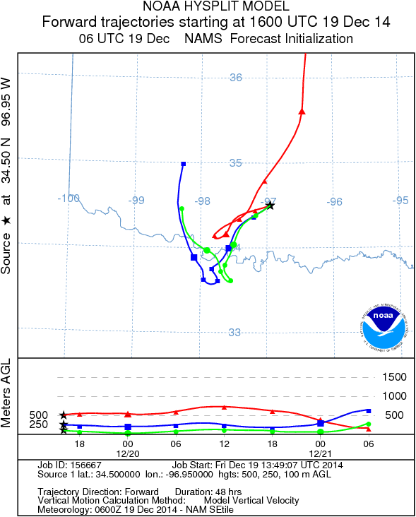
Trajectory Start (s)
(shown by black star
on map): Davis, OK
Prepared by: Estelle Levetin (Faculty
of Biological Science, The University of Tulsa, 800 S. Tucker Dr.,
Tulsa, OK 74104) and Peter
K Van de Water
(Department of Earth and Environmental Science, California State
University Fresno, 2576 East San Ramon Avenue, M/S ST24, Fresno CA
93740-8039). This forecast gives the anticipated future track of
released Mountain Cedar pollen, weather conditions over the region and
along the forecast pathway, and an estimated time of arrival for
various metropolitan areas.
Questions: Aerobiology Lab e-mail: pollen@utulsa.edu