
The University of Tulsa
Mountain Cedar Pollen Forecast
Metropolitan Area |
Exposure Risk |
|
Dallas/Fort Worth |
High |
|
Austin |
High |
|
San Antonio |
High |
Date Issued: 20 December 2014
Mountain Cedar Location(s):
Edwards Plateau, Texas
Regional Weather:
Saturday and Sunday,
December 20 and 21 – TX/OK: Across the region today
skies will begin partly
cloudy to mostly cloudy with morning fog.
Temperatures will return to the 50’s region wide. Across the Edwards
Plateau, winds will be
from the south and southeast, but shifting to the northeast in the
surrounding communities. Winds will be light regionally. Into the
evening temperatures will fall into
the 40’s, upper 30’ to the north in southern Oklahoma, with light winds
continuing from the south. Skies will build from partly cloudy to mostly
cloudy
overnight. Temperatures will be seasonally
mild with reading across the region in the 40’s. Tomorrow mostly cloudy
skies will begin to
break-up with the I-35 corridor becoming mostly sunny. Temperatures
will climb into the upper 50’s
with San Antonio expected to reach into the low 60’s. Winds will be
from the southwest over the
Edwards Plateau and from the south across the remainder of the region.
In
areas, such as the western side of the Plateau winds will build up to 10
to 15
miles per hour. Tomorrow night, cloudy
skies will continue to dissipate, with the Edwards Plateau becoming
mostly
clear. The edge communities to the north
will remain partly cloudy. Temperatures
will be in the low 40s wand a dominant southerly flow will occur across
the region
for the entirety of the forecast area.
Trajectory weather: Air mass trajectories over Texas will evolve with conditions
stabilizing after the moister conditions earlier in the week. Skies will be cloudy but clearing towards
tomorrow, and temperatures will be mild with highs expected in the mid to upper
50’s today and a few degrees warmer tomorrow.
Air mass trajectories will initially move to the south then east with an
overall clockwise movement to the west and then northward across west
Texas. The weekend is expected to be
very mild across the entire forecast area and very good for the release and
entrainment of pollen. Temperatures will
be moderate with areas in the 50s, however San Antonio may reach 60 today and
tomorrow much of the western Edwards Plateau will achieve similar warmth.
OUTLOOK: *** High Threat Today and High Threat Tomorrow
*** good conditions for pollen release today, with warm temperatures and light
winds. Yesterday’s pollen levels were
building from the showers on Thursday.
Yesterday had improving conditions that will be good for pollen
dispersal, entrainment and travel. The
trees are already pollinating and areas of heavy pollen concentrations have
been recorded, especially along the I-35 corridor from San Antonio north to
Waco. Tomorrow conditions will continue
to improve with temperatures in the upper 50s to low 60s and with clearing
skies. As the trees dry out pollen
conditions for release will improve, especially in the warmer southern
areas. For that reason we are expecting a
high threat of pollen in the atmosphere today and tomorrow.
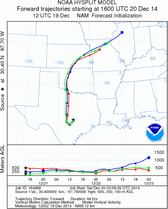
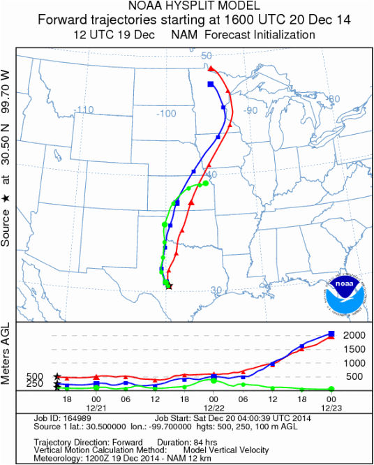
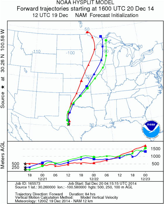
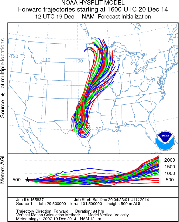
Trajectory Start (s) (shown by * on map): Austin, TX; Junction, TX; Sonora, TX.
AUSTIN
JUNCTION
SONORA
EDWARDS PLATEAU COMPOSITE
Prepared by: Estelle Levetin (Faculty
of Biological Science, The University of Tulsa, 800 S. Tucker Dr., Tulsa, OK
74104) and ) and Peter K Van de Water
(Department of Earth and Environmental Science, California
State University Fresno, 2576 East San Ramon Avenue, M/S ST24, Fresno
CA 93740-8039). This forecast gives the anticipated future track of
released Mountain Cedar pollen, weather conditions over the region and
along the forecast pathway, and an estimated time of arrival for
various metropolitan areas.
Questions: Aerobiology Lab e-mail: pollen@utulsa.edu