Date Issued: 19 December 1998
Mountain Cedar location(s): Edwards Plateau, Texas
Regional weather: Saturday, December 19 - TX/OK: Cold front is pushing through Texas with Arctic air coming down from the north. OK and the northern half of TX are cloudy and cold, temps in the 20's to the low 40's today. Southern half of TX is partly cloudy and warm, highs today in the 60's and 70's. Grand majority of locales will be mostly cloudy on Sunday.....exceptions being far west and southern Texas. Chance of light precipitation in parts of OK and western TX, including much of the Edwards Plateau. Highs in the 20's to the 40's much of OK and north TX, 50's to 70's elsewhere. Lows tonight 20's and 30's north......40's to 60's south.
Trajectory weather: Austin: Mostly sunny today, partly cloudy tonight. High today in the upper 60's, lows tonight in the 40's. Cloudy with a high around 50 on Sunday. Junction/SanAngelo: Becoming cloudy with a high in the 50's today. Cloudy tonight with areas of light rain or freezing drizzle near the panhandle, lows upper 20's west, low 30's east. Cloudy and cold on Sunday with a chance of snow flurries or freezing drizzle, high in the 20's.
Trajectory confidence: High
OUTLOOK: *** Low to Moderate Threat *** Mixed conditions concerning pollen release today. Some rain fell on the Edwards Plateau on Friday, mostly on the western and northern sections. Other sections had rain but many areas received less than a tenth of an inch, so enough drying may take place today for some pollen release. However, relative humidities are still above the tolerance zones in some areas (especially western sections) at 1pm local time. Temperatures are generally warm enough for release. Overall......some release will probably occur today during the afternoon hours, mostly from the southern and eastern sides of the plateau. Pollen released from the Austin area....which is moving the slowest.....appears to have the most potential to create any ill effects. Residents near the source area in south-central Texas (Austin, San Antonio) may be affected today and tonight. Airborne pollen from today's release will be moving into north-central TX on Sunday. On Sunday.....the situation is similar with the potential for greater release with another day of drying. Western sections of the Plateau will likely be too humid again, so any release should come from the southern and eastern sections. Trajectories indicate any airborne pollen will be moving into north Texas Sunday and Sunday night. Residents of Waco may feel effects by early evening....while people in Abilene, Dallas, and Ft. Worth may be affected overnight. Conditions are unfavorable for pollen release from the other source areas in the Arbuckle Mountains and the Ozark Mountains both today and Sunday. TK
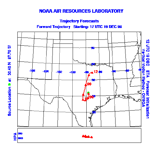
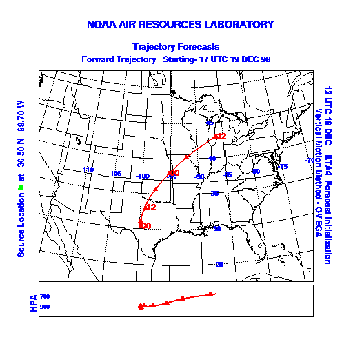
Trajectory Start(s) (shown by green dot on map): Austin, TX; Junction, TX; San Angelo, TX
Austin, TX
Junction, TX
San Angelo, TX
Prepared by: Thomas Keever (Department of Marine, Earth and Atmospheric Sciences, NCSU), Estelle Levetin (Faculty of Biological Science, The University of Tulsa, 600 S. College, Tulsa, OK 74104), and C.E. Main (Department of Plant Pathology, North Carolina State University, Raleigh, NC 27695-7618). This forecast gives the anticipated future track of released Mountain Cedar pollen, weather conditions over the region and along the forecast pathway, and an estimated time of arrival for various metropolitan areas.