
The University of Tulsa
Mountain Cedar Pollen Forecast
Metropolitan Area |
Exposure Risk |
|
Dallas/Fort Worth |
Low |
|
Austin |
Low |
|
San Antonio |
Low |
Date Issued: 1 February 2011
Mountain Cedar Location(s): Edwards Plateau, Texas
Regional Weather: Tuesday, February 1 TX/OK: Conditions
across the region will be a significant push of cold air from the north for the rest of the week, with temperatures
beginning to drop Monday night and conditions becoming dangerous in many communities. In both Oklahoma and Texas
today cloudy skies occur with significant chances of snow to the north and rain in central and southern regions
of central Texas. The edge communities will be the warmest with temperatures just getting into the lowest 50s
in the southern most communities. To the west the high temperatures will be in the 20s and 30s whereas along
the eastern edge communities temperatures will be in the mid 30s to mid 40s for the high temperatures. Winds
will be strong throughout the area from the north with the eastern edge communities experiencing gusts in the high
30 mile an hour range. Precipitation will be falling with snow to the far north, freezing rain and sleet across
north central region (often turning from rain to freezing rain and sleet) to rain along the southern areas. Tonight
partly to mostly cloudy skies will remain and the very cold temperatures will take over. Low temperatures will
be in the single digits in central Oklahoma, and the teen south and westward across the region. The eastern edge
communities will be in the low twenties. Winds will remain from the north at strong levels. In all areas the
combination of strong winds and frigid conditions will lead to wind chill values that could be life threatening
if prolonged exposure occurs. Tomorrow some clearing will occur along the eastern edge communities, but the remainder
of the region will remain partly to mostly cloudy. High temperatures will be in the low 20s to mid 30s getting
warmer towards the south and east. Winds will begin to slacken especially to the west. Gustiness is expected
along the eastern side of the Edwards Plateau. Tomorrow night low temperatures will be even colder with low teens
expected across the entire region and areas in Oklahoma in the single digits. Winds will continue from the north
at moderate levels.
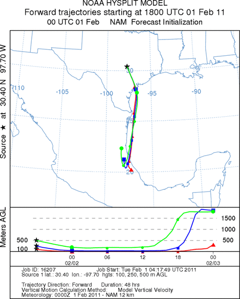
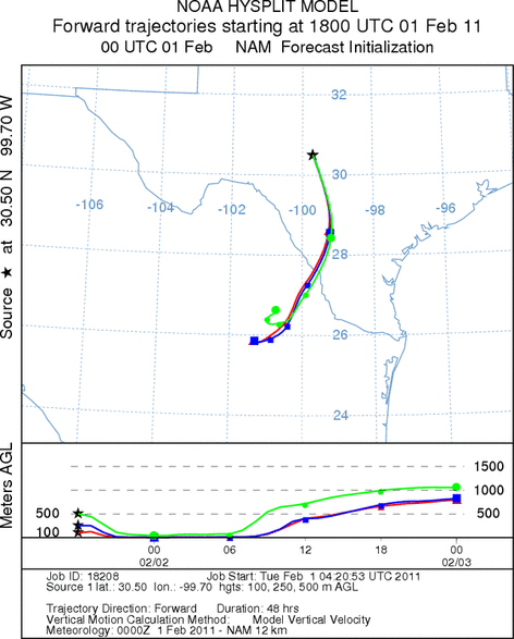
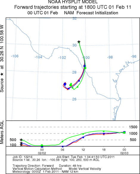
Trajectory weather: Air mass trajectories from the Edwards Plateau move south towards southern Texas and
the Gulf Coast today, tonight and tomorrow. The air is extremely cold and dense moving along the ground. High
winds drive the atmosphere southward at a quickened pace. The air is dense during the first approximately third
of the travel then begins to interact with more buoyant conditions. Temperatures across the region will be frigid
to the point that no pollen is expected to be in the air for the next few days. Temperatures get colder tomorrow
and tomorrow night, with conditions becoming life threatening with the wind chills factored in. Be careful.
OUTLOOK: *** Low Threat today and Low Threat Tomorrow *** poor conditions for pollen release today and tomorrow
with cold temperatures in the area. Poor conditions for entrainment and travel today and tomorrow. Cold conditions
today and especially tomorrow will be poor for pollen cones to open and shed their pollen. In addition poor conditions
will occur for shedding pollen to become entrained into the atmosphere with cold dense air across the region.
In addition, today a significant weather system from the north moves across the region bringing the chance of freezing
rain and snow. Winds will increase becoming moderate to strong today and tonight. The cold temperatures will
last for the next few days with highs at or below freezing and nighttime temperatures in the teens and single digits
in most places.
Trajectory Start (s) (shown by *
on map): Austin, TX; Junction, TX; Sonora, TX.
AUSTIN
JUNCTION
SONORA
EDWARDS PLATEAU COMPOSITE
Prepared by: Estelle
Levetin (Faculty of Biological
Science, The
University of Tulsa, 800 S. Tucker Dr., Tulsa, OK 74104) and ) and Peter
K Van de Water (Department of Earth and Environmental Science, California State University Fresno,
2576 East San Ramon Avenue, M/S ST24, Fresno CA 93740-8039). This forecast gives the anticipated future track of
released Mountain Cedar pollen, weather conditions over the region and along the forecast pathway, and an estimated
time of arrival for various metropolitan areas.
Questions: Aerobiology Lab e-mail: pollen@utulsa.edu
Return to Forecasting Home Page