
The University of Tulsa
Mountain Cedar Pollen Forecast
Metropolitan Area |
Exposure Risk |
|
Dallas/Fort Worth |
Low |
|
Austin |
Low |
|
San Antonio |
Low |
Date Issued: 4 February 2011
Mountain Cedar Location(s): Edwards Plateau, Texas
Regional Weather: Thursday, February 4 TX/OK:
Conditions across the region will continue today under the significant push of cold air from the north, but temperatures
will begin the slow climb out of below freezing conditions. In both Oklahoma and Texas mostly to partly cloudy
skies will occur with relatively dry conditions except over the central Edwards Plateau. There is a 20% to 30%
chance of snow over the northern areas of the central Plateau and up to a 50% chance of snow and rain mix southward
in the San Antonio region. High temperatures today will be in the lower 30s in Oklahoma and in the upper 30s
to just getting to 40 in the southern communities around the Edwards Plateau. Winds will be from the southwest
in Oklahoma, and from the northwest across most of central and east central Texas. To the west, winds will be
from the west. Winds will be light to moderate. Tonight partly cloudy conditions will exist from the north to
the south across the Edwards Plateau and in the communities along the eastern edge of the Plateau. Mostly clear
skies will be present throughout the western area. Temperatures will be in the mid to low 20s across the region
overnight with winds primarily from the west at low to moderate conditions. Tomorrow the areas of Oklahoma will
be partly cloudy whereas the rest of the forecast area will see mostly sunny to sunny skies. Temperatures will
rebound to seasonal conditions with most areas over the Edwards Plateau in the 50s and 60s. From the Dallas/Fort
Worth area northward expect slightly cooler conditions with forecast high temperatures continuing in the 30s to
40s.. Tomorrow night mostly cloudy to partly cloudy conditions will occur from Dallas northward. There will
be a 20% chance of snow in central Oklahoma. Further south clear skies will be present with low temperatures in
the upper 20s to low 30s. Winds will be light to moderate from the southwest and west.
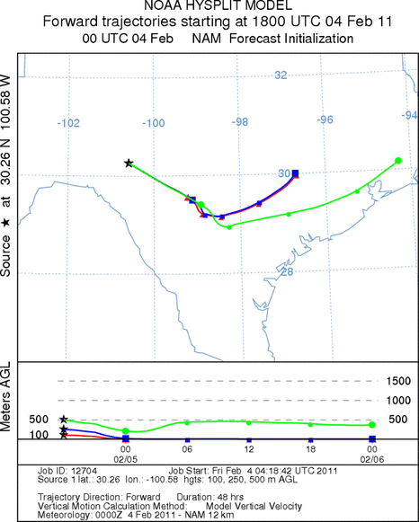
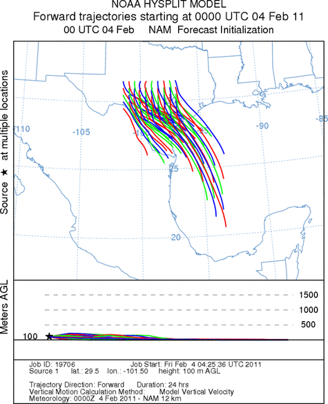
Trajectory weather: Air mass trajectories from the Edwards Plateau move towards the southeast on northwest
winds over most of the Plateau and from the west in the western areas of the Plateau. Overnight the winds become
more westerly. Today there is a chance of snow across the eastern Plateau spilling into the edge communities.
Temperatures will remain in the 30s in most areas but along the southern Plateau edge 40s will be recorded.
In these communities precipitation will fall as rain. The southwest flow remains in the forecast tomorrow with
winds becoming light to moderate. Tomorrow night mostly clear to partly clear skies will occur. Temperatures
will be in the upper 20s to low 30s along the edge communities. Winds will return to light conditions and stay
from the west to southwest. The air remains cold and dense moving along the ground. There is no buoyancy whatsoever
to the atmosphere with the lingering cold temperatures region wide, no pollen is expected to be shed today or tomorrow.
Temperatures across the region will be cold throughout the forecast period. Warmer conditions appear to be building
towards the weekend
OUTLOOK: *** Low Threat today and Low Threat Tomorrow *** poor conditions for pollen release today and tomorrow
with cold temperatures in the area. Poor conditions for entrainment and travel today and tomorrow. Cold conditions
will remain today and tomorrow and result in poor conditions for pollen cones to open and shed their pollen. In
addition poor conditions will occur for shed pollen to become entrained into the atmosphere with cold dense air
across the region. A weather system moves across the region today bringing a chance of snow for the north central
Texas region. Winds will remain light to moderate today, tonight and tomorrow. The cold temperatures will last
for at least today then significant warming begins with tomorrows temperatures 10 to 20 degrees higher. Warm
conditions are expected for Sunday as well.
Trajectory Start (s) (shown by *
on map): Austin, TX; Junction, TX; Sonora, TX.
AUSTIN
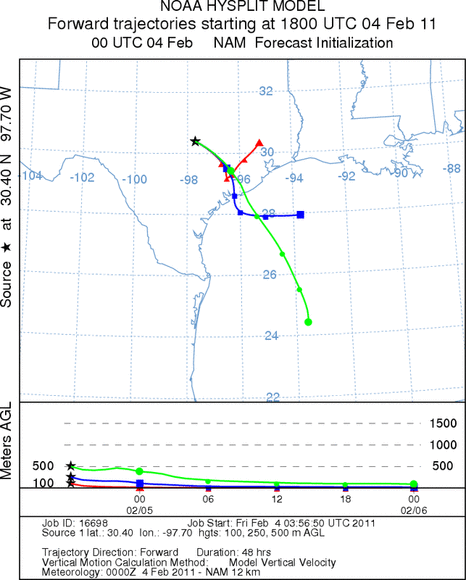
JUNCTION
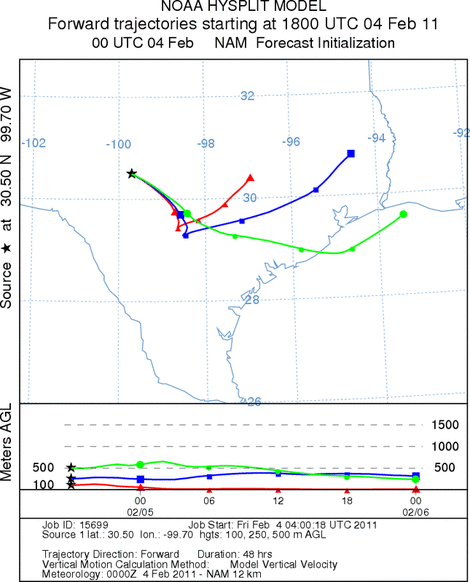
SONORA
EDWARDS PLATEAU COMPOSITE
Prepared by: Estelle
Levetin (Faculty of Biological
Science, The
University of Tulsa, 800 S. Tucker Dr., Tulsa, OK 74104) and ) and Peter
K Van de Water (Department of Earth and Environmental Science, California State University Fresno,
2576 East San Ramon Avenue, M/S ST24, Fresno CA 93740-8039). This forecast gives the anticipated future track of
released Mountain Cedar pollen, weather conditions over the region and along the forecast pathway, and an estimated
time of arrival for various metropolitan areas.
Questions: Aerobiology Lab e-mail: pollen@utulsa.edu
Return to Forecasting Home Page