The University of Tulsa
Mountain Cedar Pollen Forecast

Metropolitan Area |
Exposure Risk |
|
Oklahoma City |
Low |
|
Tulsa |
Low |
|
St. Louis MO |
Low |
Date Issued: 5 February 2011
Mountain Cedar Location(s): Arbuckle Mountains, OK
Regional Weather: Saturday, February 5 TX/OK: Conditions
across the region will continue to warm today from the significant push of cold air from the north earlier in the
week. In Oklahoma partly cloudy skies will occur with relatively dry conditions. In Texas mostly sunny conditions
to sunny skies will prevail. The area will be dry overall with high temperatures in the upper 30s in north Texas
but in the 50s on the Edwards Plateau region and San Antonio possibly making it into the low 60s. Winds will
be from the southwest across the area. Light winds to the north and light to moderate winds across the remainder
of the region. To the west winds will pick up being light to moderate. Tonight most areas will be in the upper
20s under mostly to partly cloudy skies in Oklahoma and south towards Dallas. Further south mostly clear conditions
will prevail with low temperatures in the upper 20s across the Plateau and mid- to lower 30s in the edge communities
surrounding the Plateau. Tomorrow the areas from Dallas north will continue to have a mix of winter weather with
the chance of freezing rain and snow in and around Dallas to a 30% to 40% chance of snow towards Oklahoma City.
Winds will be light towards the north and light to moderate further south. The winds will be from the west to
begin the day shifting to the northwest going into the evening. The chance of rain and snow will extend into northwest
and west Texas as similar conditions will occur in San Angelo. The Edwards Plateau region will return to warmer
conditions but most other areas will remain in the upper 40s. The edge communities will be in the 50s and low
60s in the southern areas. Winds will be gaining strength from the west across the Plateau and from the northwest
in the west Texas area. In the edge communities gusts around 30 miles per hour are expected. Tomorrow night cloudy
to mostly cloudy conditions will occur across the region. There will be a slight cooling with temperatures well
entrenched into the mid-20s.
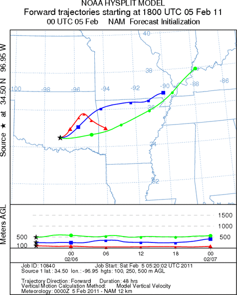
Trajectory weather: Air mass trajectories from the Arbuckle Mountains move northeast on southwest winds
today and then turn as westerly winds tonight and northwesterly winds tomorrow occur. The northwest flow remains
in the forecast tomorrow evening as well. The air remains cold and dense moving along the ground. Light to moderate
winds drive the atmosphere northeastward during todays forecast period towards Tulsa, however temperatures will
remain cold across the region. There is no buoyancy whatsoever to the atmosphere with the lingering cold temperatures
region wide, no pollen is expected to be shed today or tomorrow. Temperatures across the region will be cold throughout
the forecast period. Warmer conditions are building to the south but there is no indication of their movement northward.
OUTLOOK: *** Low Threat today and Low Threat Tomorrow *** poor conditions
for pollen release today and tomorrow with cold temperatures in the area. Poor conditions for entrainment and
travel today and tomorrow. Cold conditions will remain today and tomorrow and results in poor conditions for pollen
cones to open and shed their pollen. In addition poor conditions will occur for shedding pollen to become entrained
into the atmosphere with cold dense air across the region and light winds throughout the forecast. A weather system
will move across the region tonight and into tomorrow bringing a chance of snow for the Oklahoma region extending
into the north Texas region. A 40% chance of snowfall is expected tomorrow in the area where the junipers grow.
Winds will remain light and variable today, tonight and tomorrow. The cold temperatures will last for at least
today and tomorrow, although warming is occurring further south across Texas.
Trajectory Start (s) (shown by black
star on map): Davis, OK.
Prepared by: Estelle
Levetin
(Faculty
of Biological Science, The University of Tulsa, 800 S. Tucker Dr., Tulsa, OK 74104) and Peter
K Van de Water
(Department of Earth and Environmental Science, California State University Fresno, 2576 East San Ramon Avenue,
M/S ST24, Fresno CA 93740-8039). This forecast gives the anticipated future track of released Mountain Cedar pollen,
weather conditions over the region and along the forecast pathway, and an estimated time of arrival for various
metropolitan areas.
Questions: Aerobiology Lab e-mail: pollen@utulsa.edu
Return to Forecasting Home Page