
The University of Tulsa
Mountain Cedar Pollen Forecast
Metropolitan Area |
Exposure Risk |
|
Dallas/Fort Worth |
Low |
|
Austin |
Low |
|
San Antonio |
Low to Moderate |
Date Issued: 6 February 2011
Mountain Cedar Location(s): Edwards Plateau, Texas
Regional Weather: Sunday, February 6 TX/OK:
Conditions across the region will continue to warm today from cold conditions earlier in the week. In Oklahoma
cloudy conditions will occur today with a significant chance for rain and snow. Temperatures will be in the low
40s to the north and as high as 50 degrees across north Texas with light winds from the north. The chance of
precipitation will continue into this evening with temperatures dropping into the 20s to the north and the lower
30s in the Dallas/Fort Worth metro region. Tomorrow, partly cloudy skies are expected with high temperatures
in the lower 40s and light winds from the northwest. Tomorrow night will see partial clearing with temperatures
in the upper 20s and winds switching from the north to a southeasterly flow. Further south in Texas today, warm
temperatures are expected with conditions in the 50s across the Edwards Plateau, and in the 60s to low 70s in
the edge communities from Austin towards San Antonio. To the north temperatures will drop towards northern Texas.
Winds will be light to moderate from the west today along the eastern edge of the Edwards Plateau, and from the
northwest at moderate to strong conditions in the western side of the area. Some areas of west Texas may also
be affected by the system moving through to the north as San Angelo has a 30% chance of rain today. Overnight,
partly cloudy to mostly cloudy conditions will occur with temperatures dropping into the 20s to the west and into
the mid- to upper-30s in the Edwards Plateau edge communities. Tomorrow, sunny and mostly sunny skies return
with temperatures cooling by five or ten degrees. Areas across the forecast region will return into the 50s and
60s. The cooling will be brought into the area with dominant north and northwesterly winds at light to moderate
conditions. Tomorrow night will be partly cloudy with lows mostly in the low 30s. Winds tomorrow night will
begin to shift towards a more southerly flow. This will begin in the western regions then southeastern winds will
build towards the eastern edge communities.
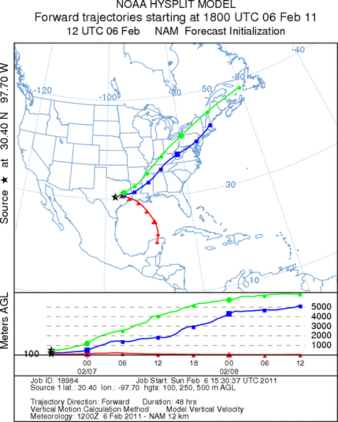
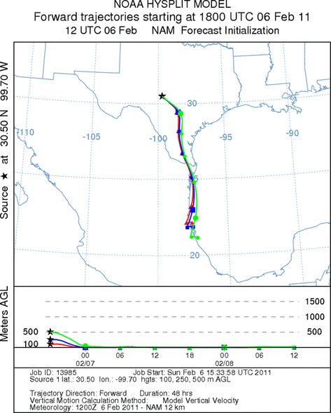
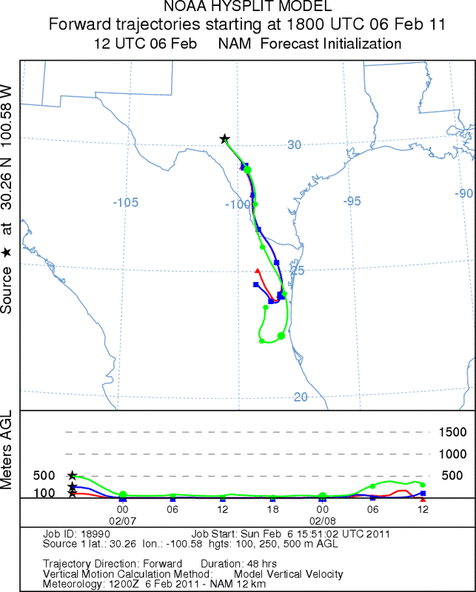
Trajectory weather: Air mass trajectories from the Edwards Plateau move towards the south and southeast
on north to northwesterly over most the Plateau. Winds will be light to moderate along the eastern edge of the
Plateau, but stronger to the west. Winds will begin from the southwest and west early but move to a northwesterly
and northerly flow this afternoon and tonight. North and northwesterly winds remain in the forecast at moderate
to strong levels tonight and tomorrow, then begins to shift towards a southerly flow tomorrow night. Temperatures
today will be in the 60s and 70s along the Edwards Plateau today with the plateau and areas to the west in the
upper 50s. Tomorrow, the northerly winds will cool the area off by five to ten degrees. Today skies will be
mostly sunny to the east but partly to mostly cloudy over the Edwards Plateau and in western communities. Tomorrow,
mostly sunny to sunny conditions will occur over the region. With all of the changes, the atmosphere at the ground
continues to be dense travelling at ground level. Most of the trajectories move southward towards south Texas
and the Gulf of Mexico. There are a few trajectories in the northeasterly portion of the modeled area that get
caught in the system moving through the northern portion of the Texas and southern Oklahoma and take-off towards
the east coast. The population of ash juniper in these areas are minimal and the wind is not expected to have
juniper pollen entrained within them.
OUTLOOK: *** Low-Moderate Threat today and Moderate Threat Tomorrow
*** poor to moderate conditions for pollen release today and tomorrow with warming temperatures in the area.
Poor conditions for entrainment and travel today and tomorrow. Warming conditions will occur today and tomorrow
and result in the potential for moderate conditions for pollen cones to open and shed their pollen across the southern
portion of the Edwards Plateau. Recently the southern stations have reported pollen levels falling off dramatically.
This warming will tell if the season is nearing its end. Further north, temperatures will remain at or below
the threshold for pollen release and the passage of a weather system should reduce pollen levels. It is unclear
at this time if the recent severe weather throughout the area significantly affected cones that have yet to shed
pollen. Previously there has been a loss of cones especially during freezing rain and sleet conditions In addition
poor conditions will occur for shed pollen to become entrained into the atmosphere with cold dense air across the
region. A weather system moves across the northern region today bringing a chance of snow for the north Texas
region. Winds will remain light to moderate northward and much stronger across the Plateau today and tonight with
increased gustiness and moderate conditions tomorrow. The cold nighttime temperatures will last for at least today
and tomorrow with most areas in the twenties overnight.
Trajectory Start (s) (shown by *
on map): Austin, TX; Junction, TX; Sonora, TX.
AUSTIN
JUNCTION
SONORA
EDWARDS PLATEAU COMPOSITE
Prepared by: Estelle
Levetin (Faculty of Biological
Science, The
University of Tulsa, 800 S. Tucker Dr., Tulsa, OK 74104) and ) and Peter
K Van de Water (Department of Earth and Environmental Science, California State University Fresno,
2576 East San Ramon Avenue, M/S ST24, Fresno CA 93740-8039). This forecast gives the anticipated future track of
released Mountain Cedar pollen, weather conditions over the region and along the forecast pathway, and an estimated
time of arrival for various metropolitan areas.
Questions: Aerobiology Lab e-mail: pollen@utulsa.edu
Return to Forecasting Home Page