
The University of Tulsa
Mountain Cedar Pollen Forecast
Metropolitan Area |
Exposure Risk |
|
Dallas/Fort Worth |
Low |
|
Austin |
Low to Moderate |
|
San Antonio |
Low to Moderate |
Date Issued: 7 February 2011
Mountain Cedar Location(s): Edwards Plateau, Texas
Regional Weather: Monday, February 7 TX/OK:
Conditions across the region will continue to recover from the recent cold event last week. In Oklahoma partly
cloudy conditions will occur today with temperatures in the low 40s. Winds will be from the northwest at light
conditions. Overnight the skies will remain as mostly to partly cloudy. Temperatures will be in the upper 20s
and winds will shift overnight coming from the south to southeast. Tomorrow the chance of snow or rain builds
in central Oklahoma with Oklahoma City having a 20% chance of precipitation. High temperatures will be in the
upper 30s and winds will be strong from the southeast at 15 to 20 miles per hour. The skies will remain cloudy
tomorrow night with a 70% chance of snow, rain and freezing rain occurring. Temperatures will drop into the teens,
and winds will remain from the north to northeast at light to moderate conditions. In Texas, partly sunny to mostly
sunny conditions will occur around the eastern and northern edge and over the Edwards Plateau. Temperatures will
be warming into the 50s in most areas, with the southernmost areas approaching 60. The Dallas/Fort Worth area
will remain in the 40s. Winds will be from the north to northwest to begin the day. Overnight a southerly wind
begins to take over with partly to mostly cloudy skies. Temperatures will be in the upper 20s in north Texas and
into Oklahoma, whereas to the south most areas will register in the lower 30s for their low temperatures. Tomorrow
mostly sunny to partly sunny skies will remain in the northern Texas area as well as in the eastern edge communities
around the Edwards Plateau. On the Plateau itself, and off to the west cloudy to partly cloudy conditions will
prevail. Temperatures will warm into the 60s tomorrow ahead of another front moving through the region. Winds
will be from the south and will pick up intensity with most areas in the 15 to 25 mile per hour range late in the
afternoon, going into the evening hours. Tomorrow night cloudy conditions build as the chance of rain across the
entire region rises with the passage of a front through the area. Winds will continue to be strong with most areas
to the east experiencing very gust conditions. Winds will begin from the southeast but turn during the nighttime
hours to a northerly direction.
Trajectory weather: Air mass trajectories from the Edwards Plateau move towards the south to southeast today on
light winds from the north and west. This afternoon and tonight the winds switch coming from the south to southeast
but continue at light conditions. Tomorrow the trajectories begin a quick movement northward on moderate to strong
winds from the south. Tomorrow night the winds begin to be turned back to a northerly direction as a system moves
through the area. Over the forecast period temperatures will remain cold to the north with warming into the 50s
to the south. Along the edge of the Edwards Plateau temperatures will be in the 60 in the southern communities.
Today mostly sunny to sunny conditions will occur over the region. However, the atmosphere at the ground continues
to be dense travelling at ground level. Most of the trajectories move southeastward then reverse heading towards
the north, travelling across western portions of Texas and western Oklahoma. Tomorrow night warmer nighttime lows
are expected, but the chance of precipitation is forecast across the entire region. Winds will become quite gusty
as the system moves into the area and the dominant south to southeasterly flow of winds reverses to a northerly
flow.
OUTLOOK: *** Low-Moderate Threat today and Moderate Threat Tomorrow *** moderate conditions for pollen release
today and tomorrow with warming temperatures in the area. Poor conditions for entrainment and travel today and
tomorrow. Warming conditions will occur today and tomorrow and result in the potential for moderate conditions
for pollen cones to open and shed any pollen left within the populations across the southern portion of the Edwards
Plateau. Recently the southern stations have reported pollen levels falling off dramatically. This warming will
tell if the season is nearing its end. It is unclear at this time if the recent severe weather throughout the
area significantly affected cones that have yet to shed pollen. Previously there has been a loss of cones especially
during freezing rain and sleet conditions. The storm forecast for tomorrow night is expected to bring more freezing
rain conditions to the area. In addition to poor conditions for pollen shedding there is also poor conditions
for that pollen to become entrained into the atmosphere with dense air across the region. A weather system moves
across the northern region beginning tomorrow then the southern extension is expected through tomorrow night.
Winds will remain light to moderate today and tonight from the north. This evening winds will begin to shift coming
around to a southerly direction. The winds will remain moderate. Tomorrow in the afternoon winds will pick up
to much stronger levels with increased gustiness. The warming of nighttime temperatures will last for at least
today and tomorrow with most areas in the thirties tonight and close to forty in the eastern areas tomorrow night.
Tomorrow night the western areas will remain cold with overnight lows in the 20s.
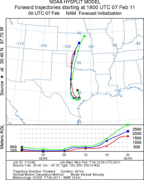
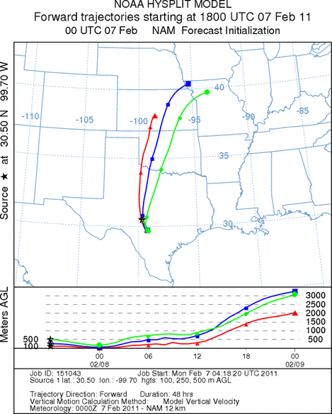
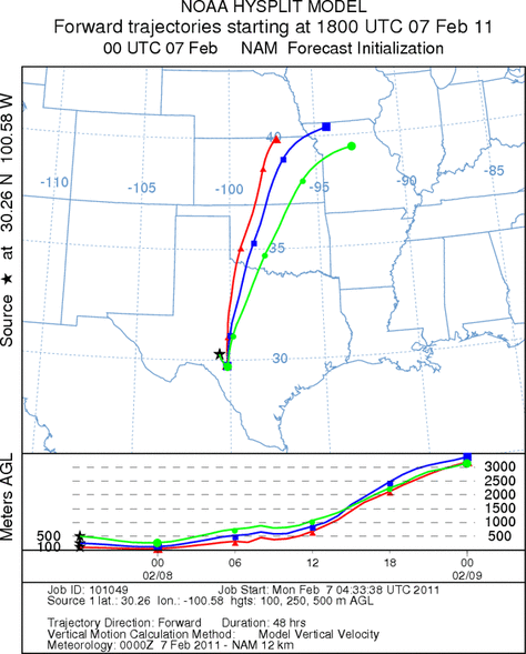
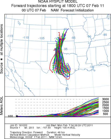
Trajectory Start (s) (shown by *
on map): Austin, TX; Junction, TX; Sonora, TX.
AUSTIN
JUNCTION
SONORA
EDWARDS PLATEAU COMPOSITE
Prepared by: Estelle
Levetin (Faculty of Biological
Science, The
University of Tulsa, 800 S. Tucker Dr., Tulsa, OK 74104) and ) and Peter
K Van de Water (Department of Earth and Environmental Science, California State University Fresno,
2576 East San Ramon Avenue, M/S ST24, Fresno CA 93740-8039). This forecast gives the anticipated future track of
released Mountain Cedar pollen, weather conditions over the region and along the forecast pathway, and an estimated
time of arrival for various metropolitan areas.
Questions: Aerobiology Lab e-mail: pollen@utulsa.edu
Return to Forecasting Home Page