
The University of Tulsa
Mountain Cedar Pollen Forecast
Metropolitan Area |
Exposure Risk |
|
Dallas/Fort Worth |
Low |
|
Austin |
Low |
|
San Antonio |
Low |
Date Issued: 8 February 2011
Mountain Cedar Location(s): Edwards Plateau, Texas
Regional Weather: Tuesday, February 8 TX/OK:
Conditions across the region will begin to degrade today from the recent warming as the region gets ready to receive
the next system from the north. Temperatures in Oklahoma today will be in the upper 30s with a chance of rain
and snow in the Oklahoma City region. Winds will start from the southeast at moderate to strong conditions. As
the front moves through, winds will shift to a northerly flow with much colder air behind them. Tonight the Oklahoma
region has a 70% chance of rain, freezing rain, and snow with temperatures in the teens and winds from the north
to northeast at strong to moderate levels. Tomorrow cloudy skies and the chance of snow dominate the forecast
with high temperatures only getting into the high teens and low twenties. Winds tomorrow will be from the north
at moderate to strong levels and gusts in some areas around 30 miles per hour. Tomorrow night snow is once again
forecast with temperatures in the single digits and strong northwest winds gusting to 25 miles per hour. In Texas
today temperatures will start in the 60s in most areas with moderate to strong southeasterly breezes. The high
temperatures will arrive early with a significant cool down as a front from the north pushes into the region.
Skies will have begun mostly sunny to partly sunny in the eastern areas but partly cloudy to cloudy skies to the
west are an omen of the system that will arrive tonight. Tonight partly cloudy to cloudy conditions will build
as temperatures cool. Overnight lows will be in the 20s to the west and low 30 over the Plateau. Along the edge
communities low temperatures will remain in the upper 30s to mid 40,s. There is a chance of precipitation across
the entire region in the form of rain and light freezing rain, especially to the west where it will be colder.
Winds will start from the southeast but turn with the passing of the front to a northerly flow bringing dense
cold air with them. Winds overnight will be strong with gusts as high as 45 miles per hour across the Texas region.
Tomorrow partly cloudy to mostly cloudy skies will occur with temperatures reaching only into the low 40s to
the east and southeast. The west will only reach the mid to low 30s . Tomorrow night mostly to partly cloudy
skies will prevail with temperatures in the teens to the west and in the low to mid 20s over the rest of the forecast
area. Winds will remain from the north with moderate conditions to the west and the east retaining strong winds
and gusts up to 45 miles per hour.
Trajectory weather: Air mass trajectories from the Arbuckle Mountains move northwest and then north on winds
that then take them north of Oklahoma where they are incorporated into a push of air heading at high elevations
towards the east coast. There is a building chance of precipitation in central Oklahoma tomorrow In Texas the
same increasing chance of precipitation with cold conditions moving in from the north will begin to be felt tomorrow
afternoon into the evening hours. Along with this weather change will come increasing amounts of moderate to high
winds. The flow from the south and southeast will be overtaken by a northerly and northwesterly flow. Winds strengths
will become strong with gusts in the 30 to 45 mile per hour range. Temperatures are headed down once again with
overnight lows in the upper thirties to low forties in the surrounding edge communities, but to the west lows will
be in the twenties. Tomrrow most of the Edwards Plateau has a chance of rain, freezing rain and snow. Highs will
rise into the 40s in the areas that are usually warmer, but stay in the 30s across the rest of the Plateau.
Winds will remain strong and gusty from the north. Tomorrow night temperatures will be in the teens and low twenties
across the region. The air is relatively dense near the ground and thus there is little lift if any pollen does
get entrained. The strong winds and cold temperatures recently should have scoured out any open cones that had
residual pollen in them and thus not much pollen should be in the air over the next two days.
OUTLOOK: *** Low Threat today and Low Threat Tomorrow *** poor conditions for pollen release today and tomorrow
with cold temperatures in the area. Poor conditions exist for entrainment and travel today and tomorrow. Cold
conditions, partly cloudy skies and the chance of precipitation tonight and tomorrow will remain in the forecast.
These conditions are poor for pollen cones to open and shed their pollen. In addition poor conditions will occur
for shed pollen to become entrained into the atmosphere with cold dense air across the region. A weather system
will move across the area beginning this afternoon and especially tonight bringing a chance of snow, rain and freezing
rain starting in Oklahoma and spreading across Texas. Winds will be strong throughout the forecast with gust ranging
from 25 to 45 miles per hour. The cold temperatures will last for at least today and tomorrow. There is some
indication that the pollination season is beginning to wrap up. Over the last two or three days of good conditions
across Texas little pollen was observed at some of the monitoring stations. However, weather conditions will be
poor for any kind of pollination and entrainment over the next couple of days
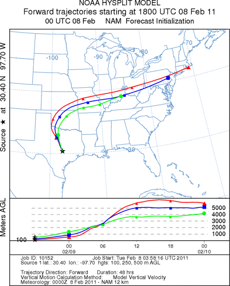
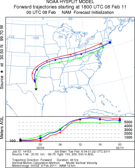
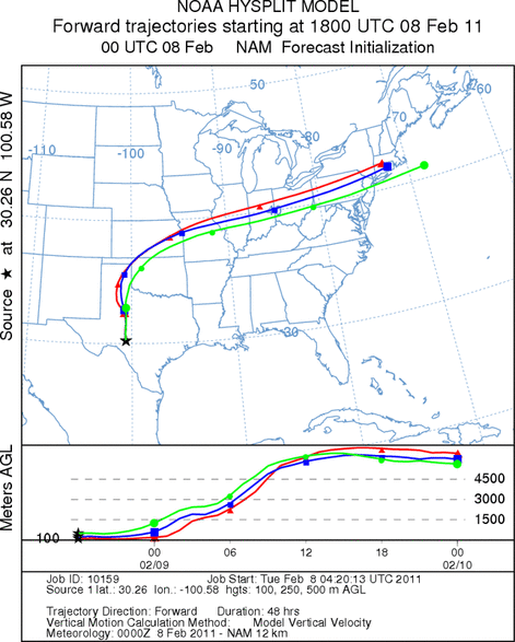
Trajectory Start (s) (shown by *
on map): Austin, TX; Junction, TX; Sonora, TX.
AUSTIN
JUNCTION
SONORA
EDWARDS PLATEAU COMPOSITE
Prepared by: Estelle
Levetin (Faculty of Biological
Science, The
University of Tulsa, 800 S. Tucker Dr., Tulsa, OK 74104) and ) and Peter
K Van de Water (Department of Earth and Environmental Science, California State University Fresno,
2576 East San Ramon Avenue, M/S ST24, Fresno CA 93740-8039). This forecast gives the anticipated future track of
released Mountain Cedar pollen, weather conditions over the region and along the forecast pathway, and an estimated
time of arrival for various metropolitan areas.
Questions: Aerobiology Lab e-mail: pollen@utulsa.edu
Return to Forecasting Home Page