The University of Tulsa
Mountain Cedar Pollen Forecast

Metropolitan Area |
Exposure Risk |
|
Oklahoma City |
Low |
|
Tulsa |
Low |
|
St. Louis MO |
Low |
Date Issued: 13 February 2011
Mountain Cedar Location(s): Arbuckle Mountains, OK
Regional Weather: Sunday, February 13 TX/OK:
Conditions across the region will be warm again today under sunny skies. In Oklahoma sunny skies will bring the
region into the 60s today. Winds will be from the south over the region at light and variable speeds up to 10
miles per hour this afternoon. Tonight clear skies in southern Oklahoma and partly cloudy further north will occur
with low temperatures at or just below the freezing levels. Winds will remain from the south at 10 miles per hour.
Tomorrow the 60s will return to the region. However, winds will switch and be coming from the northeast at light
to moderate strengths. Tomorrow night will have partly cloudy skies with a building chance of rain (20%) in the
southern Oklahoma area. Lows will be in and around 40 degrees with light winds from the southeast. In Texas,
sunny skies will occur with most areas in the 60s and low 70s today. Winds will be moderate to light across
most of the Plateau from the southwest during the day. In the edge communities moderate winds will pick up during
the afternoon from the south to southwest. Tonight clear to mostly clear skies will occur across the area with
low temperatures hovering in and around the freezing mark. Areas to the west will tend to be a little cooler whereas
the edge communities to the east will be just above freezing. Winds will remain at light to moderate conditions
from the south to southwest. Tomorrow sunny and mostly sunny skies will occur region wide. The edge communities
can expect some morning fog. High temperatures will be in the mid- to upper 60s with areas along the edge of
the Edwards Plateau and on the Plateau in the low 70s. Winds will be from the south at light to moderate levels.
In the most western communities winds will shift, coming from the northeast. Tomorrow night mostly cloudy skies
will occur with low temperatures relatively warm. The edge communities will only drop into the low 50s. To the
west colder conditions will occur with lows expected to be in the upper 30s and low 40s.
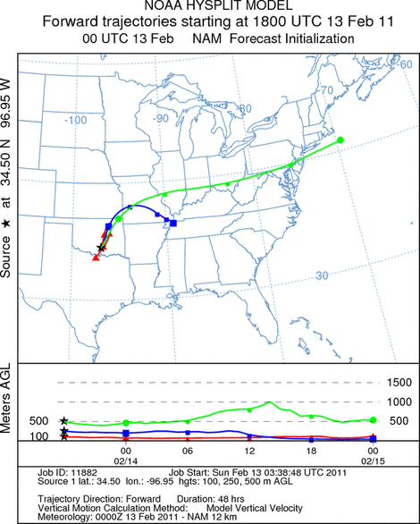
Trajectory weather: Air mass trajectories at the ground from the Arbuckle Mountains move north to northeast
on light southwestern winds over central Oklahoma, then reverse their course overnight as light northeasterly winds
take over. Temperatures will be in the upper 60s in most areas today with a slight cooling into the mid to lower
60s tomorrow. Clear and sunny skies will occur both days over the entire region. Overnight lows will be in the
upper 20s to low 30s tonight warming above freezing tomorrow night and staying in the mid 40s.. The air remains
dense today and tonight. Light to moderate conditions will move any entrained pollen over the ground surface removing
entrained particles through the process of impaction. Tomorrow winds will continue to be light to moderate, skies
will be sunny and high temperatures cooling slightly.
OUTLOOK: *** Moderate Threat today and Moderate Threat Tomorrow *** good conditions
for pollen release today and tomorrow with warm temperatures throughout the area. Moderate to poor conditions
will occur for entrainment, and poor travel conditions exist today and tomorrow. Warm conditions with sunny skies
and light to moderate winds will occur today and tomorrow. Today high temperatures will be in the mid to upper
60s across the region. These temperatures are conducive for pollen release, however the number of cones left
to release pollen from is diminishing as the end of the season nears. Where pollen is available, light winds will
entrain pollen into the atmosphere but dense air flowing at ground level should remove a significant portion of
it through impaction as it moves at ground level. The wind trajectories show the ground level atmosphere moving
into central Oklahoma but reversing overnight and retracing todays travel back towards juniper population. Tomorrow,
good conditions will continue with warming into the 60s. Conditions will be similar for pollen release, but entrainment
will remain problematic with light to moderate winds to entrain and move the pollen downwind . There is building
evidence that the pollination season is beginning to wrap up. Some of the stations in the area report a significant
reduction in pollen in the atmosphere. During the last string of days with good conditions across Texas little
pollen was observed at some of these monitoring stations. This weekend with the warm temperatures across the region
will be telling in terms of the overall contribution of Ashe juniper pollen to the atmosphere. Winds from the south
could potentially bring pollen from Texas over eastern-most Oklahoma. See the Texas forecast for details.
Trajectory Start (s) (shown by black
star on map): Davis, OK.
Prepared by: Estelle
Levetin
(Faculty
of Biological Science, The University of Tulsa, 800 S. Tucker Dr., Tulsa, OK 74104) and Peter
K Van de Water
(Department of Earth and Environmental Science, California State University Fresno, 2576 East San Ramon Avenue,
M/S ST24, Fresno CA 93740-8039). This forecast gives the anticipated future track of released Mountain Cedar pollen,
weather conditions over the region and along the forecast pathway, and an estimated time of arrival for various
metropolitan areas.
Questions: Aerobiology Lab e-mail: pollen@utulsa.edu
Return to Forecasting Home Page