
The University of Tulsa
Mountain Cedar Pollen Forecast
Metropolitan Area |
Exposure Risk |
|
Dallas/Fort Worth |
High |
|
Austin |
Low |
|
San Antonio |
Low |
Date Issued: 13 February 2011
Mountain Cedar Location(s): Edwards Plateau, Texas
Regional Weather: Sunday, February 13 TX/OK:
Conditions across the region will be warm again today under sunny skies. In Oklahoma sunny skies will bring the
region into the 60s today. Winds will be from the south over the region at light and variable up to 10 miles
per hour this afternoon. Tonight clear skies in southern Oklahoma and partly cloudy further north will occur with
low temperatures at or just below the freezing levels. Winds will remain from the south at 10 miles per hour.
Tomorrow the 60s will return to the region. Howecver, winds will switch and be coming from the northeast at
light to moderate strengths. Tomorrow night will have partly cloudy skies with a building chance of rain (20%)
in the southern Oklahoma area. Lows will be in and around 40 degrees with light winds from the southeast. In
Texas, sunny skies will occur with most areas in the 60s and low 70s today. Winds will be moderate to light
across most of the Plateau from the southwest during the day. In the edge communities moderate winds will pick
up during the afternoon from the south to southwest. Tonight clear to mostly clear skies will occur across the
area with low temperatures hovering in and around the freezing mark. Areas to the west will tend to be a little
cooler whereas the edge communities to the east will be just above freezing. Winds will remain at light to moderate
conditions from the south to southwest. Tomorrow sunny and mostly sunny skies will occur region wide. The edge
communities can expect some morning fog. High temperatures will be in the mid- to upper 60s with areas along
the edge of the Edwards Plateau and on the Plateau in the low 70s. Winds will be from the south at light to moderate
levels. In the most western communities winds will shift, coming from the northeast. Tomorrow night mostly cloudy
skies will occur with low temperatures relatively warm. The edge communities will only drop into the low 50s.
To the west colder conditions will occur with low temperatures expected to be in the upper 30s and low 40s.
Trajectory weather: Air mass trajectories at the ground from the Edwards Plateau region moves northeast
on light southwestern winds over southeastern most Oklahoma, then reverse their course overnight as light northeasterly
winds take over. Temperatures will be range from the upper 60s to mid- 70s in most areas today and tomorrow.
Clear and sunny skies will occur both days over the entire region, however clouds will build tomorrow night for
partly to mostly cloudy conditions. Overnight lows will be in the upper 20s to low 30s tonight warming above
freezing tomorrow night and staying in the mid 40s.. The air remains dense today and tonight travelling near
the ground at the lowest levels. This afternoon slightly stronger winds are expected and provide the greatest
chance of pollen entrainment and travel. Overnight the winds calm to light and moderate conditions. Light to
moderate winds will move any entrained pollen over the ground surface removing entrained particles through the
process of impaction. Tomorrow winds will continue to be light to moderate, skies will be sunny and high temperatures
cooling slightly.
OUTLOOK: *** Moderate Threat today and Moderate Threat Tomorrow *** good conditions
for pollen release today and tomorrow with warm temperatures throughout the area. Moderate conditions for entrainment
and moderate travel conditions today and tomorrow. Warm conditions, with sunny skies and light to moderate winds
will occur today and tomorrow. These conditions are seen as being good to very good for pollen release. However,
the trees have been shedding pollen for some time and traditionally the end of the pollen season occurs in early
February. Regional pollen collectors appear to be tapering off with only minor amounts of juniper pollen being
recorded. The past couple of days with really nice conditions for release, entrainment and travel will signal
an extension of the pollination season or a winding down of the release period. The moderate to light winds but
stable atmosphere will take pollen from central Texas and move it northeastward. The winds will carry any entrained
pollen at or near the elevation at which it is released thus the chance of impaction and overall cleansing of the
pollen out of the atmosphere will be greater than with a more buoyant conditions.
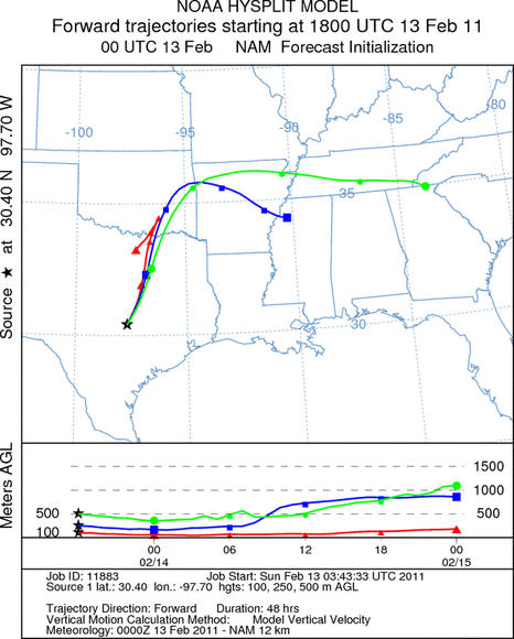
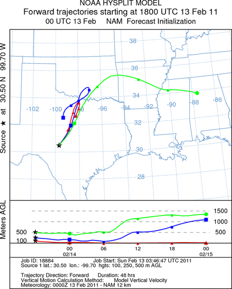
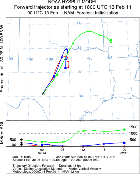
Trajectory Start (s) (shown by *
on map): Austin, TX; Junction, TX; Sonora, TX.
AUSTIN
JUNCTION
SONORA
EDWARDS PLATEAU COMPOSITE
Prepared by: Estelle
Levetin (Faculty of Biological
Science, The
University of Tulsa, 800 S. Tucker Dr., Tulsa, OK 74104) and ) and Peter
K Van de Water (Department of Earth and Environmental Science, California State University Fresno,
2576 East San Ramon Avenue, M/S ST24, Fresno CA 93740-8039). This forecast gives the anticipated future track of
released Mountain Cedar pollen, weather conditions over the region and along the forecast pathway, and an estimated
time of arrival for various metropolitan areas.
Questions: Aerobiology Lab e-mail: pollen@utulsa.edu
Return to Forecasting Home Page