Date Issued: 1 January 2000
Mountain Cedar location(s): Arbuckle Mountains, OK
Regional weather: Saturday, January 1 - TX/OK: Some clouds and fog/drizzle parts of southern TX. A few high clouds in western TX. Otherwise, fair to sunny skies. A low pressure / frontal system is developing and moving east out of the central Rockies. This first Low will scoot to the northeast, dragging its cold front behind it. Another Low will form along the front and may bring some clouds and rain to eastern sections of this region by late Sunday or Monday. Until then.... mostly dry and warm. Highs in the 60's and 70's today and Sunday with a few 50's northwest sections on Sunday. Lows in the 30's north and west to 50's east and south.
Trajectory weather: Partly cloudy today, high in the upper 60's. Mostly cloudy tonight with light rain, low near 40. Good chance of rain Sunday, high in the mid-40's.
Trajectory confidence: High
OUTLOOK: *** Moderate Threat *** Conditions are mostly favorable for pollen release today. Temperatures and humidities will be favorable during the afternoon hours. Residents of central OK and southeast KS are most likely to feel any ill effects from today's release. Washout of airborne pollen appears likely after this evening. TK
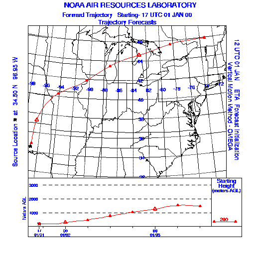
Trajectory Start(s) (shown by the * on map): Sulfur, Oklahoma
Prepared by: Thomas Keever (Department of Marine, Earth and Atmospheric Sciences, NCSU), Estelle Levetin (Faculty of Biological Science, The University of Tulsa, 600 S. College, Tulsa, OK 74104), and C.E. Main (Department of Plant Pathology, North Carolina State University, Raleigh, NC 27695-7618). This forecast gives the anticipated future track of released Mountain Cedar pollen, weather conditions over the region and along the forecast pathway, and an estimated time of arrival for various metropolitan areas.
Questions: Aerobiology Lab e-mail: pollen@utulsa.edu
Return to Forecasting Home Page