Date Issued: 15 January 2000
Mountain Cedar location(s): Arbuckle Mountains, OK
Regional weather: Friday/Saturday, January 14/15 - TX/OK: High pressure will control the weather for the weekend. Moist flow off the Gulf of Mexico is causing some clouds and showers in deep South TX and some variable cloudiness in south-central TX. Cloudiness will increase today for other parts of southern TX and there may be some drizzle tonight. Otherwise, fair weather will prevail, and the chance of rain will diminish for southern TX as the center of the High moves away to the east. Late-night/early morning clouds in some areas Saturday night are expected. Warming trend through the weekend. Highs today 50's and 60's, lows tonight 30's to 50's, highs Saturday 60's and 70's.
Trajectory weather: Mostly sunny today, high in the 60's. Partly cloudy tonight, low near 40. Dry with a high around 60 on Sunday.
Trajectory confidence: High
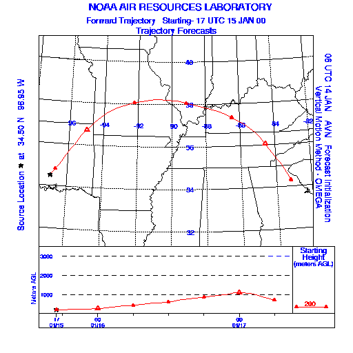
OUTLOOK: *** Serious Threat *** Conditions are favorable for pollen release. Strong release expected. Temperatures and humidities are favorable much of the day. Airborne pollen will be moving into northeast OK (including the Tulsa area) later this afternoon.... and across southern MO and southern IL tonight. Residents of western KY may also be affected. TK
Trajectory Start(s) (shown by the * on map): Sulfur, Oklahoma
Prepared by: Thomas Keever (Department of Marine, Earth and Atmospheric Sciences, NCSU), Estelle Levetin (Faculty of Biological Science, The University of Tulsa, 600 S. College, Tulsa, OK 74104), and C.E. Main (Department of Plant Pathology, North Carolina State University, Raleigh, NC 27695-7618). This forecast gives the anticipated future track of released Mountain Cedar pollen, weather conditions over the region and along the forecast pathway, and an estimated time of arrival for various metropolitan areas.
Questions: Aerobiology Lab e-mail: pollen@utulsa.edu
Return to Forecasting Home Page