Date Issued: 27 January 2000
Mountain Cedar location(s): Edwards Plateau, Texas
Regional weather: Thursday, January 27 - TX/OK: Major winter storm system invading the region. Weather is ranging from heavy snow in the northern areas to showers and thunderstorms in parts of TX. Precipitation will be slacking off tonight. Clouds will linger into Friday many areas. Cold temperatures will dominate. Extended Outlook: Cloudy most areas SAturday with decreasing cloudiness into Sunday. Remaining cold. Chance of precipitation north, east, and south with greater chances to the north.
Trajectory weather: Cloudy with morning rain, ending in the afternoon, high in the 50's. Becoming partly cloudy tonight, low in the 40's. Mostly cloudy Friday, high in the 50's.
Trajectory confidence: High
OUTLOOK: *** Low Threat *** Forecast Notes: Severe winter weather has prohibited the generation of any trajectories for Tuesday and Wednesday, January 25 and 26. Trajectories and some weather data are available and we will describe the situations below. Current forecasts will include anticipated weather for the weekend of January 28-30. We will make every attempt to produce forecasts on Saturday, January 29 that will cover Saturday through Monday, January 29th-31st. More severe winter weather at the Forecaster's location is expected Saturday night and Sunday, with unknown consequences. *** For Tuesday, January 25.... A cold front moved through the region with little precipitation. Conditions for pollen release were probably Mild to Moderate. Persons living in central and western TX were most likely to feel any ill effects. On Wednesday..... moisture invaded the region as circulation around the High pressure (centered to the north) brought winds off the Gulf. Trajectories moved north and west. Conditions were unfavorable for release along the eastern Plateau increasing to mixed favorability in the western sections of the Plateau. Residents of western TX.... from the Plateau northward through the Panhandle... were most likely to feel any ill effects. For Thursday..... conditions are unfavorable for pollen release. Temperature will not reach the favorable range in most areas. Humidities are high and rain occurred in many sections of the Plateau this morning. On Friday..... conditions will again be unfavorable for release with continued cold temperatures and high atmospheric moisture. Little to no release today and Friday. Saturday and Sunday..... the weather will be unfavorable for pollen release. More cold temperatures are in store, and moisture levels will be up, especially in the eastern areas of the Plateau. TK
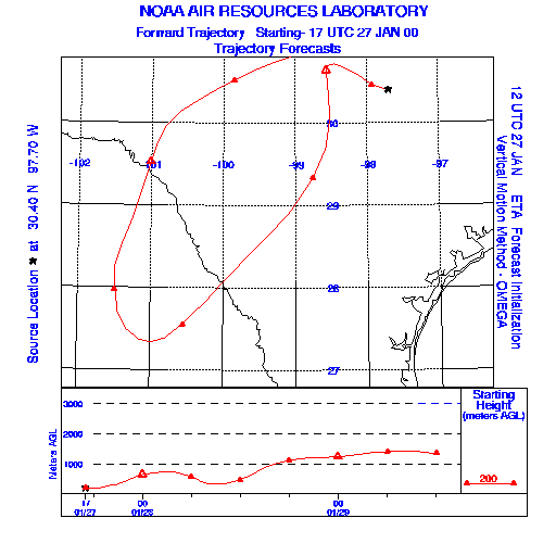
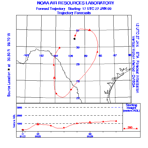
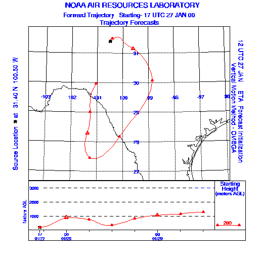
Trajectory Start(s) (shown by * on map): Austin, TX; Junction, TX; San Angelo, TX
Austin, TX
Junction, TX
San Angelo, TX
Prepared by: Thomas Keever (Department of Marine, Earth and Atmospheric Sciences, NCSU), Estelle Levetin (Faculty of Biological Science, The University of Tulsa, 600 S. College, Tulsa, OK 74104), and C.E. Main (Department of Plant Pathology, North Carolina State University, Raleigh, NC 27695-7618). This forecast gives the anticipated future track of released Mountain Cedar pollen, weather conditions over the region and along the forecast pathway, and an estimated time of arrival for various metropolitan areas.
Questions: Aerobiology Lab e-mail: pollen@utulsa.edu
Return to Forecasting Home Page