University of Tulsa
Mountain Cedar Pollen Forecast
Date Issued: 10 January 2001
Mountain Cedar location(s): Ozark Mountains, AR/MO
Regional weather: Wednesday, January 10 - TX/OK/AR: High pressure has moved off to the east. A low pressure disturbance fueled by strong upper-level energy is pounding TX this morning. Cloudy all but northwest AR today. Rain/showers will be moving north and east through the day. Precipitation will end in parts of west TX this evening but continue in other areas tonight. Highs ranging from the 40's to 60's, lows in the 30's and 40's with some 50's south. Clearing and warmer for much of the region on Thursday, though parts of eastern OK, eastern TX, and AR will remain unsettled.
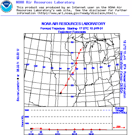
Trajectory weather: Increasing high clouds with a high today in the mid-40's. Becoming cloudy tonight, low in the low 30's. Chance of rain on Thursday, high in the upper 30's.
Trajectory confidence: High
OUTLOOK: *** Low Threat *** Conditions are unfavorable for pollen release today. Temperatures near the source may be favorable this afternoon but only for a few hours. Humidities are behaving similarly.... dropping slowly and only reaching the favorable range for one or two hours at most. Winds are moderate. Little to no release expected today, with Low Risk of exposure. TK
Trajectory Start(s) (shown by black star on map): Oak Grove, AR
Prepared by: Thomas Keever (Department of Marine, Earth and Atmospheric Sciences, NCSU), Estelle Levetin (Faculty of Biological Science, The University of Tulsa, 600 S. College, Tulsa, OK 74104), and C.E. Main (Department of Plant Pathology, North Carolina State University, Raleigh, NC 27695-7618). This forecast gives the anticipated future track of released Mountain Cedar pollen, weather conditions over the region and along the forecast pathway, and an estimated time of arrival for various metropolitan areas.
Questions: Aerobiology Lab e-mail: pollen@utulsa.edu
Return to Forecasting Home Page