|
Metropolitan Area |
Exposure Risk |
|
Dallas / Ft. Worth |
Low |
|
Austin |
Low |
|
San Antonio |
Low |
Mountain Cedar location(s): Edwards Plateau, Texas
Regional weather: Friday, January 12 - TX/OK/AR: Weak high pressure over the region today will shift east as the next system approaches from the west. This frontal system will pass through the region on Saturday, triggering showers over most areas with the best chances to the north. Clearing later Saturday, clear to partly cloudy on Sunday. Low clouds and fog covering the eastern 2/3 of the region most of the day, rather than just half a day as thought earlier. High cloudiness invading the western sections this afternoon. Highs today and Sunday mostly in the 40's and 50's, 50's and 60's on Saturday. Lows ranging from the 30's to 50's tonight and Saturday night.
Trajectory weather: Cloudy today with a high near 50 east and low 60's west. Chance of showers tonight, low in the 30's. Rain or snow on Saturday, changing to all snow. Temperatures steady or slowly falling into the 20's.
Trajectory confidence: High.
OUTLOOK: *** Low Threat *** Unfavorable conditions for pollen release. Temperatures have risen slowly today as the low clouds and fog have persisted in many areas of the Plateau. Mid-afternoon temperatures in the west have climbed a bit higher as more sunshine has occurred there. Still, humidities have remained high even in the western sections of the Plateau and are still at 90% or better in the east. Winds are light in the east, moderate in the west. Overall.... little to no release expected today, with Low Risk of exposure. Any that does occur will be from the west. On Saturday..... more clouds and fog are likely and rain chances range from possible to likely from west to east. Temperatures will be favorable but high humidities and precipitation should preclude any pollen release. Low Risk of exposure on Saturday. On Sunday... again, rains the previous day and lingering moisture should inhibit pollen release. TK
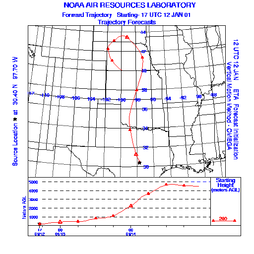
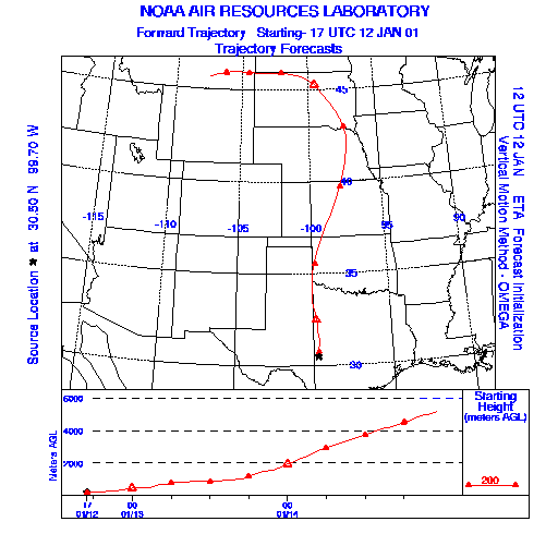
Trajectory Start(s) (shown by * on map): Austin, TX; Junction, TX; San Angelo, TX
Austin, TX
Junction, TX
San Angelo, TX
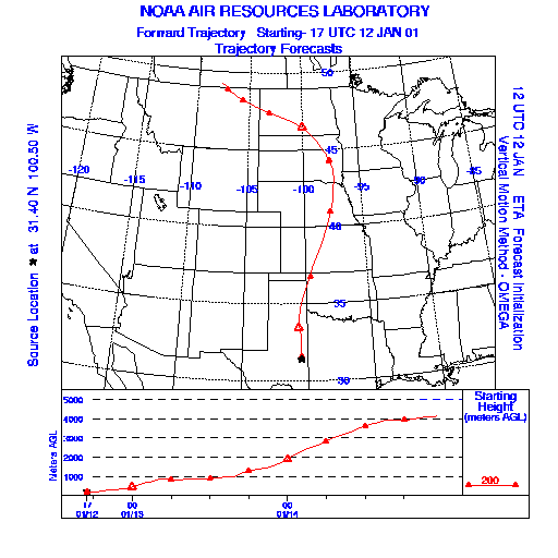
Prepared by: Thomas Keever (Department of Marine, Earth and Atmospheric Sciences, NCSU), Estelle Levetin (Faculty of Biological Science, The University of Tulsa, 600 S. College, Tulsa, OK 74104), and C.E. Main (Department of Plant Pathology, North Carolina State University, Raleigh, NC 27695-7618). This forecast gives the anticipated future track of released Mountain Cedar pollen, weather conditions over the region and along the forecast pathway, and an estimated time of arrival for various metropolitan areas.
Questions: Aerobiology Lab e-mail: pollen@utulsa.edu
Return to Forecasting Home Page