University of Tulsa
Mountain Cedar Pollen Forecast
Date Issued: 23 January 2001
Mountain Cedar location(s): Ozark Mountains, AR/MO
Regional weather: Tuesday, January 23 - TX/OK/AR: High pressure surrounds the region today. A weak cold front will move through the region tonight, aided by some upper-level moisture and energy. The majority effect is and will be some mid to high-level cloudiness, some fog, and a slight chance of rain for some areas. Most locations will remain dry. Highs today mostly in the 50's and 60's, lows tonight mostly 30's and 40's.
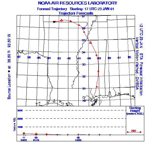
Trajectory weather: Variably to mostly cloudy today, high in the mid-40's. Variably cloudy tonight, low in the low 30's. Becoming partly cloudy on Wednesday, high near 50.
Trajectory confidence: High
OUTLOOK: *** Low Threat *** Conditions are unfavorable for pollen release today. Temperatures this afternoon will barely reach the tolerance range, borderline at best. Humidities are high through midday and will remain so. Winds are generally light. Little to no release expected, with Low Risk of exposure. TK
Trajectory Start(s) (shown by black star on map): Oak Grove, AR
Prepared by: Thomas Keever (Department of Marine, Earth and Atmospheric Sciences, NCSU), Estelle Levetin (Faculty of Biological Science, The University of Tulsa, 600 S. College, Tulsa, OK 74104), and C.E. Main (Department of Plant Pathology, North Carolina State University, Raleigh, NC 27695-7618). This forecast gives the anticipated future track of released Mountain Cedar pollen, weather conditions over the region and along the forecast pathway, and an estimated time of arrival for various metropolitan areas.
Questions: Aerobiology Lab e-mail: pollen@utulsa.edu
Return to Forecasting Home Page