University of Tulsa
Mountain Cedar Pollen Forecast
|
Metropolitan Area |
Exposure Risk |
|
Dallas / Ft. Worth |
Mod |
|
Austin |
Mod to High |
|
San Antonio |
Low |
Date Issued: 07January 2002
Mountain Cedar location(s): Edwards Plateau, Texas
Regional weather: Monday, January 07 TX/OK/AR: Sunny conditions from Sunday will continue on Monday and Tuesday with a significant warming trend over the next couple of days. High pressure begins to build over the region starting on Monday and continues through the week. Winds will be moderate from the north during the day on Monday and then shift to the south over night but be calm. To the north, in Oklahoma and the Ozark Mountains, winds will be from the west switching to the southwest overnight. High temperatures across the Edwards Plateau and Hill Country will reach the upper 50 s on Monday and into the mid to upper 60 s on Tuesday. Lows overnight on Monday will be in the mid 30 s warming to the mid 40 s on Tuesday. To the north temperatures will be 10 degrees cooler all around with highs on Monday in the upper 40 s and upper 50 s to low 60 s on Tuesday. Low temperatures will be near or below freezing Monday night and in the lower 40 s to upper 30 s on Tuesday night. Winds in this region will remain moderate to light out of the southwest on Tuesday. Throughout the entire region sunny skies will stay clear on Monday night and only northern Oklahoma will see partly cloudy conditions on Tuesday but then clear towards the evening.
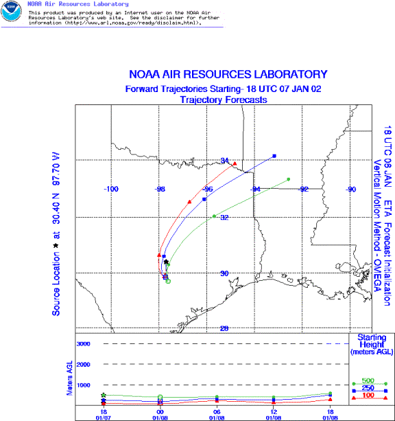
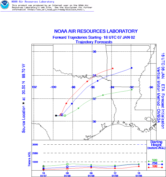
Trajectory weather: The air mass trajectories from the sites in Texas all move to the northeast towards the direction of the low pressure that is moving out of the area. High pressure over the Rockies will feed a north to northwest wind field switching to a south to southwest direction as high pressure builds over the state. Drying conditions will prevail and warm temperatures will characterize Tuesday and beyond.
Trajectory confidence: High.
OUTLOOK: *** Moderate to Serious threat today *** favorable conditions for pollen release today. Over the plateau warming temperatures and humidity on the decline will produce conditions becoming favorable for pollen release today. As the week progresses these conditions should lead to very favorable conditions for release. The air masses trajectory characteristics only show moderately rising air today nd low wind speeds, which is not wholly conducive to entrainment and travel. Pollen that is released and entrained will move to the north to northeast over the Dallas and Fort Worth areas. Deposition of pollen entrained on Monday will occur over these areas. Conditions for release are improving and the initial models for Tuesday indicate continued movement towards the north. Watch for tomorrows forecast as significant entrainment and travel may be in the winds.
Trajectory Start(s) (shown by *on map): Austin, TX; Junction, TX; San Angelo, TX
Austin, TX
Junction, TX
San Angelo, TX
Prepared by: Peter K. Van de Water (Department of Geosciences, Oregon State University), and Estelle Levetin (Faculty of Biological Science, The University of Tulsa, 600 S. College, Tulsa, OK 74104) This forecast gives the anticipated future track of released Mountain Cedar pollen, weather conditions over the region and along the forecast pathway, and an estimated time of arrival for various metropolitan areas.
Questions: Aerobiology Lab e-mail: pollen@utulsa.edu
Return to ForecastingHome Page