University of Tulsa
Mountain Cedar Pollen Forecast
|
Metropolitan Area |
Exposure Risk |
|
Dallas / Ft. Worth |
Mod/ Mod |
|
Austin |
Mod /Mod |
|
San Antonio |
Low/ Low |
Date Issued: 26 January 2002
Mountain Cedar location(s): Edwards Plateau, Texas
Regional weather: Saturday, January 26 TX/OK/AR: High pressure will bring warm unseasonable condition today and tomorrow across the southern plains. Forecast high temperatures for the area today will be in the upper 60 s with low s in the mid to upper 40 s tonight. Dry, sunny , clear conditions will occur across the region with moderate winds from the south/southwest to south blowing across the region. To the north similar conditions will prevail with high and low temperatures only 5 degrees cooler than the southern areas. Dry conditions with similar winds directions will blow across the region, however winds will be moderate to strong in some areas. On Sunday temperatures will rise by 7 to 10 degrees with highs in the upper 70 s to the south and near 70 to the north. Dry conditions and similar wind strengths will remain in place. However high clouds will begin to move across the area and partly cloudy skies can be expected in the north and to the east as the day progresses.
Trajectory weather: The surface air mass trajectories from Texas move due north on light to moderate southerly breezes from their source areas as high pressure builds across the area. Air mass characteristics show pathways rising from the source areas along each of the pathways, except for the Junction trajectory representing the southwestern Edwards Plateau population. With increased travel time and building high pressure, its trajectory at the lowest level moves along the ground north and then stalls over central Oklahoma. Temperatures will reach the upper 60 s today and into the upper 70 s tomorrow. Dry air and moderate winds from the south to southwest will occur both days providing similar trajectory pathways today and tomorrow.
Trajectory confidence: High.
OUTLOOK: *** High threat of travel today and tomorrow *** very favorable conditions for pollen release today and tomorrow. Warm temperatures, clear sunny skies and dry conditions combine to produce very favorable conditions for pollen release today and tomorrow. However, analysis of the pollen trend from the area indicates that the end of the pollen season is nearing and therefore it is expected that the overall level of pollen in the atmosphere will only reach moderate levels. Yet, there is still a chance of heightened levels in localized areas. The air mass trajectories from the Edwards Plateau all show northerly flow bringing entrained pollen over Dallas, and north over Oklahoma City and Tulsa. The trajectories from the southwestern population show movement at ground level that may act as a filter to remove pollen from the atmosphere, but the northwestern and eastern side of the Edwards Plateau shows very good conditions for entrainment and travel of any pollen that is released both today and tomorrow. Therefore moderate levels of pollen in the downwind areas are forecast.
Trajectory Start(s) (shown by *on map): Austin, TX; Junction, TX; San Angelo, TX
Austin, TX
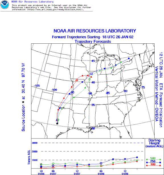
Junction, TX
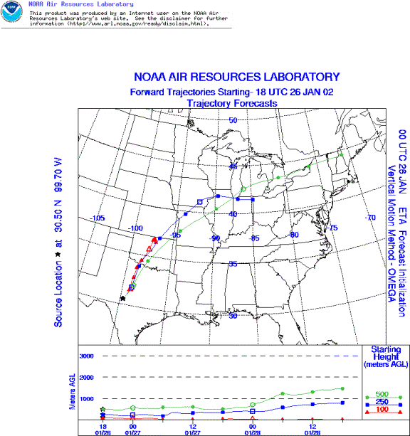
San Angelo, TX
Prepared by: Peter K. Van de Water (Department of Geosciences, Oregon State University), and Estelle Levetin (Faculty of Biological Science, The University of Tulsa, 600 S. College, Tulsa, OK 74104) This forecast gives the anticipated future track of released Mountain Cedar pollen, weather conditions over the region and along the forecast pathway, and an estimated time of arrival for various metropolitan areas.
Questions: Aerobiology Lab e-mail: pollen@utulsa.edu
Return to Forecasting Home Page