University of Tulsa
Mountain Cedar Pollen Forecast
|
Metropolitan Area |
Exposure Risk |
|
Dallas / Ft. Worth |
Mod |
|
Austin |
Low |
|
San Antonio |
Low |
Date Issued: 28 January 2002
Mountain Cedar location(s): Edwards Plateau, Texas
Regional weather: Monday, January 28 TX/OK/AR: Warm conditions will continue today and tomorrow and a cold front begins to move south towards the southern plains and a trough of low pressure continues to build towards the west. Moderate to strong south to southwesterly winds across the region will bring moisture up from the gulf today and tomorrow ahead of weather changes later in the week. High temperatures across the southern plains will be in the mid to upper 70 s with lows tonight in the upper 50 s and low 60 s. Skies will become partly cloudy towards the afternoon and mostly cloudy tonight and into tomorrow. To the north temperatures will be in the upper 60 s in Oklahoma and the Ozark Mountain region. On Tuesday rain will develop ahead of the cold front that is moving in from the north. Tuesday night and Wednesday it should be stalled across the Red River country. Cloudy skies and strong winds from the south will be ahead of it with winds switching to the north to northeast once it passes. Rain is expected to the north with an increasing chance during the day on Tuesday and up to a quarter of an inch across the area Tuesday night. Precipitation is expected across Texas on Wednesday.
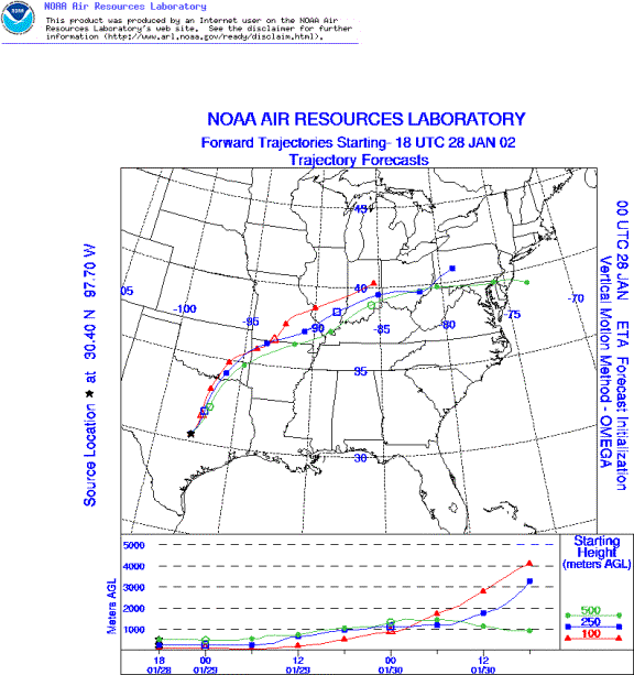
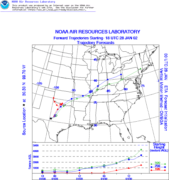
Trajectory weather: The surface air mass trajectories from the eastern side of the Edwards Plateau move due north on moderate to strong southerly breezes from their source areas. To the west the air trajectories show them initially moving north but then being caught in the developing weather patterns to the west and their northward progress reversing and the pathways moving towards the west. Air mass characteristics show pathways that do not rise immediately but are near ground surface for some time before lifting. Temperatures will reach the upper 70 s today and tomorrow. However, increasing humidity and overcast conditions with the possibility of precipitation tomorrow will balance the dispersal of pollen from the trees.
Trajectory confidence: High.
OUTLOOK: *** Moderate threat of travel today *** Moderate conditions for pollen release today. Very warm temperatures will occur throughout the area today, but skies will become increasingly cloudy and humidity is on the rise as the southerly winds pump gulf moisture into the region. In addition, analysis of the pollen trend from the area indicates that the end of the pollen season is upon us and therefore it is expected that the overall level of pollen in the atmosphere will only reach moderate levels at best. Yet, there is still a chance of heightened levels in localized areas where the trees grow. The air mass trajectories from the western Edwards Plateau show northerly flow bringing entrained pollen over Dallas. The eastern Edwards Plateau trajectory moves over southeastern Oklahoma and towards the northeast. Therefore moderate levels of pollen in the downwind areas are forecast but overall levels will continue to decrease.
Trajectory Start(s) (shown by *on map): Austin, TX; Junction, TX; San Angelo, TX
Austin, TX
Junction, TX
San Angelo, TX
Prepared by: Peter K. Van de Water (Department of Geosciences, Oregon State University), and Estelle Levetin (Faculty of Biological Science, The University of Tulsa, 600 S. College, Tulsa, OK 74104) This forecast gives the anticipated future track of released Mountain Cedar pollen, weather conditions over the region and along the forecast pathway, and an estimated time of arrival for various metropolitan areas.
Questions: Aerobiology Lab e-mail: pollen@utulsa.edu
Return to ForecastingHome Page