University of Tulsa
Mountain Cedar Pollen Forecast
|
Metropolitan Area |
Exposure Risk |
|
Dallas / Ft. Worth |
Low |
|
Austin |
Low |
|
San Antonio |
Low |
Date Issued: 29 January 2002
Mountain Cedar location(s): Edwards Plateau, Texas
Regional weather: Tuesday, January 29 TX/OK/AR: Warm conditions will continue today with some cooling tomorrow as a cold front continues from the north into Texas from Oklahoma over the next two days. In addition a strong weather system will begin to move through the area from the west during the forecast period. Today temperatures across Texas will be warm again with highs in the mid to upper 70 s and lows in the upper 50 s to lower 60 s. Strong to moderate southerly winds will continue to push humid air in from the Gulf bringing humidity up and overcast/cloudy skies will be present throughout the forecast area. To the north a significant chance of rain is forecast today with high temperatures only reaching the upper 50 s to low 60 s and lows between the low 40 s and freezing. This afternoon rain and showers are expected across the region in a band that stretches from southwest Oklahoma to the northeast. Tomorrow rain will develop across northern Texas and along the eastern edge of the Edwards Plateau. Temperatures will remain warm with highs in the mid to upper 60 s. Lows will also be warm and in the 40 s to 50s. Winds will continue from the south below the cold front stalled in northern Texas and from the north where the front has pushed through. In Oklahoma and the Ozark Mountains, high temperatures will drop into the 40s and lower 50s, with lows around freezing. Significant precipitation should fall around the area with upwards of an inch in some places. A chance of wintery mix with snow and sleet is possible for Wednesday night.
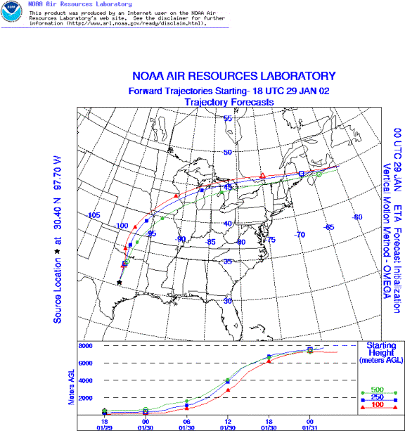
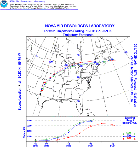
Trajectory weather: The surface air mass trajectories from the Edwards Plateau move due north on moderate to strong southerly breezes from their source areas. Air mass characteristics show pathways that travel near ground level then rise rapidly as they travel over the cold front moving south across Oklahoma into northern Texas. Temperatures will reach the upper 70 s today and tomorrow. However, humid, overcast conditions prevail with precipitation towards the north.
Trajectory confidence: High.
OUTLOOK: *** Low threat of travel today *** Most unfavorable conditions for pollen release today. Very warm temperatures will occur throughout the area today, but skies will be overcast and cloudy and high humidity readings all combine for a low chance of significant pollen release. The trees are near the end of their pollination cycle therefore adding to the low risk for release. The trajectory forecasts travel straight into conditions with significant amounts of precipitation predicted therefore any possibility of significant downwind travel and influx of pollen is low as well.
Trajectory Start(s) (shown by *on map): Austin, TX; Junction, TX; San Angelo, TX
Austin, TX
Junction, TX
San Angelo, TX
Prepared by: Peter K. Van de Water (Department of Geosciences, Oregon State University), and Estelle Levetin (Faculty of Biological Science, The University of Tulsa, 600 S. College, Tulsa, OK 74104) This forecast gives the anticipated future track of released Mountain Cedar pollen, weather conditions over the region and along the forecast pathway, and an estimated time of arrival for various metropolitan areas.
Questions: Aerobiology Lab e-mail: pollen@utulsa.edu
Return to ForecastingHome Page