The
Mountain
Cedar Pollen Forecast
Metropolitan Area |
Exposure Risk |
|
|
Severe/ Severe |
|
|
Severe/ Moderate |
|
|
Moderate/ Moderate |
Date Issued:
Mountain Cedar Location(s):
Regional Weather: Saturday, January 04 and Sunday, January 05 TX/OK/AR: High pressure has built across the region with warm sunny and dry conditions expected through the weekend. In Texas, mild conditions will continue both days as temperatures will reach the mid to upper 60s both Saturday and Sunday. Winds will be light to moderate today and from the southwest across the Texas area, then lessen overnight and tomorrow. Humidity will remain low with zero percent chance of rain over the weekend. Temperatures overnight will be mild with readings in the mid to upper 50s. Similar conditions exist to the north with a weekend of sunny warm weather. Today, high temperatures will be in the low 60s with low temperatures tonight near 40. A 5 degree cooling will occur on Sunday and skies may become partly cloudy as a low pressure system moves across the region to the north. Winds will be moderate today from the north to northwest switching to a more southerly direction tomorrow and decreasing to light wind strengths.
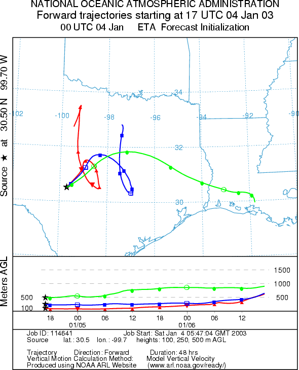
Trajectory weather: The air mass trajectories from the Texas region show relatively little movement from the western portion of the Edwards Plateau with calm winds. To the east, the low level winds also move short distances northward compared to the upper winds that get caught in the jet stream and shoot northeastward. With moderate to light conditions at the lowest level winds are expected to play the greatest role in pollen movement. The characteristics for entrainment and travel are not perfect but a significant amount of pollen should be on the move today. Warm conditions during the peak of the pollination season should lead to significant release today and tomorrow. The low level winds from the eastern edge of the Edwards Plateau move to the north-northeast over the Dallas region whereas those from the western areas are confined to the hill country and northern Texas. Sunday: On Sunday conditions will continue to be mild with light winds across the region until later in the day when winds begin to be drawn to the west towards an approaching low pressure. A quick look at forecast trajectories show similar movement as on Saturday to begin with but then the air will become buoyant and move quickly towards the west. Warm temperatures and good conditions for entrainment and travel should again bring the possibility of significant amounts of pollen to western Texas and eastern New Mexico.
OUTLOOK: *** Saturday: Severe Threat today***Favorable conditions for pollen release today. ***Sunday: Severe
Threat today ***Favorable conditions
for pollen release today. Sunny skies, with warm temperatures, low
humidity and moderate winds will prevail across the region today especially to the south making for favorable conditions
for pollen release within the trees. As we near the peak of the release season, the low humidity and warm temperatures
should favor significant pollen release. The trajectory characteristics show good conditions for entrainment and travel therefore
there is a severe threat
to downwind communities. Light
winds across the region should not carry pollen far a field but keep concentrations closer to the source. Therefore the
communities surrounding the Edwards Plateau (Austin,
Waco, Dallas/Ft. Worth) will be the most affected. To the south,
the winds should take most of the pollen towards the north but some leakage may occur back over the San Antonio area,
thus a severe threat
is forecast. Sunday: On
Sunday conditions will begin essentially the same, however wind strength direction across the region shifts to
a easterly flow across the region thus some communities in western Texas and eastern New Mexico will be impacted. Therefore we
expect favorable conditions for pollen release and a severe threat for pollen entrainment and travel to west Texas and eastern New Mexico. This includes
Lubbock, Midland, and Roswell.
Trajectory Start (s)
(shown by *
on map):
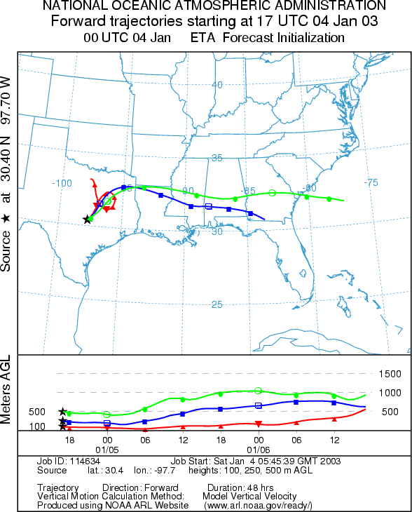
Junction, TX
Prepared by: Peter
K. Van de Water (Department of Geoscience,
Questions: Aerobiology Lab e-mail: pollen@utulsa.edu
Return to Forecasting Home Page