The
Mountain
Cedar Pollen Forecast
Metropolitan Area |
Exposure Risk |
|
|
Moderate |
|
|
Moderate |
|
|
Low |
Date Issued:
Mountain Cedar Location(s):
Regional Weather: Tuesday, January 7 TX/OK/AR: High pressure is entrenched over southern Kansas and northern Oklahoma creating clear skies across the region until you are south of San Antonio TX. The high pressure will be sliding to the southeast over the next day bringing much warmer temperatures on Wednesday. Cold temperatures overnight will make daytime temperatures today lower over the region. High temperatures across the southern area of the Edwards Plateau will be in the mid 50s with some high and medium level clouds leaking north from southern most Texas. Winds will be light across the region. Low temperatures overnight will warm by 5 degrees into the mid to upper 30s and low 40s from north to south. On Wednesday, warm temperatures will prevail with sunny skies and moderate winds. High temperatures will be in the mid to upper 60s across the region. Along with the nice conditions, humidity will be low. In Oklahoma, conditions will be similar with below temperatures Monday night and highs on Tuesday in the mid 50s. Skies will be sunny with light to moderate winds and low humidity. Overnight clear conditions will drop temperatures into the mid to low 30s region wide with light to moderate winds blowing from the southwest. Sunny conditions on Wednesday with warm temperatures into the mid 60s are in store for Wednesday.
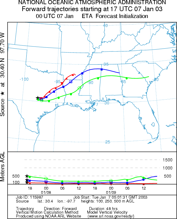
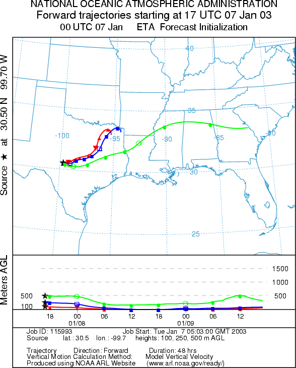
Trajectory weather: The air mass trajectories from eastern Edwards Plateau of Texas move to the northeast into southern Arkansas on light winds associated with the large high pressure over the region. The western Texas trajectories also move towards the northeast but stay within the state boundaries. The trajectories show sinking atmospheric conditions as they move relatively small distances compared to the trajectories from yesterdays forecast. Each of the trajectories shows characteristics that is associated with movement along or near the ground that tends to filter out any pollen entrained within the air mass. Conditions at the sources will be cool but dry with some clouds towards the southern areas. The trees are nearing the peak of the pollen release season and even with cool conditions pollen release is expected. Warming conditions tomorrow looks better for significant pollen release.
OUTLOOK: *** Moderate Threat today ***favorable conditions for pollen release today. Generally sunny skies with low relative humidity but with temperatures on the cool side will be the general rule today, resulting in favorable conditions for pollen release. The trees are nearing their peak release period so pollen release is expected, however the conditions are not as good as tomorrow's forecast with very warm temperatures. The high pressure over the area results in sinking atmospheric conditions so the trajectory characteristics show movement along the ground where most pollen is filtered out. However if a significant amount of pollen is released some localities may encounter sizable pollen loads in the atmosphere. Therefore a moderate threat for entrainment and travel exists. With the calm winds local communities surrounding the source areas may see heightened pollen concentrations such as in Dallas/Ft. Worth, Waco and northeastern Texas.
Trajectory Start (s)
(shown by *
on map):
Junction, TX
Prepared by: Peter
K. Van de Water (Department of Geoscience,
Questions: Aerobiology Lab e-mail: pollen@utulsa.edu
Return to Forecasting Home Page