The
Mountain
Cedar Pollen Forecast
Date Issued:
Mountain Cedar Location(s):
Regional Weather: Tuesday, January 8 TX/OK/AR: High pressure is entrenched over southeastern Texas bringing clear skies and very mild conditions across the region throughout the day today and into the evening. Tonight the next push of cold arctic air will start to move into the region from the north dropping temperatures by 10 to 12 degrees in northern localities by tomorrow. High temperatures across the southern area of the Edwards Plateau will reach the low 70s today with sunny skies and low humidity. Winds will be light across the region and out of the southwest. Low temperatures overnight will be in the upper 40s to low 50s. On Thursday, cooler temperatures will begin to work their way into the area dropping temperatures by 10 to 12 degrees as far south as Lubbock and Dallas. With these changes will come a shift in the winds to out of the north. Areas southward will see less than a 5 degree reduction in temperatures tomorrow. Overall winds will be moderate to strong in areas where the greatest temperature differences occur. In Oklahoma, conditions will be similar with warm mild, sunny conditions today. Temperatures will be in the mid to upper 60s across the region. The colder air will begin to move into the area this afternoon and into tomorrow dropping temperatures significantly. Temperatures overnight will be in the upper 40s but will rise by less than 10 degrees for highs on Thursday. Winds will shift from the predominantly light to moderate conditions today from the southwest to stronger northerly breezes overnight and into tomorrow.
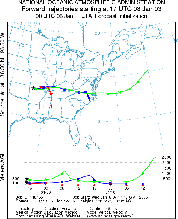
Trajectory weather: The air mass trajectories from
the
OUTLOOK: *** Moderate Threat Today*** Favorable Conditions for Pollen Release. Clear skies with low relative humidity and warm temperatures will result in favorable conditions for pollen release today. The trajectories show poor characteristics for pollen entrainment and travel at the lowest elevations with sinking atmospheric conditions thus limiting the amount that will travel downwind. However the upper elevations winds over the site show much better conditions. If the pollen reaches these levels entrainment and travel is expected towards the east. Therefore communities along the Arkansas and Missouri border may experience heightened levels in the atmosphere but beyond those areas significant deposition should drop off rapidly and therefore there is a moderate threat today.
Trajectory Start (s)
(shown by black star
on map):
Prepared by: Peter K. Van de Water (Department of Geosciences,
Questions: Aerobiology Lab e-mail: pollen@utulsa.edu
Return to Forecasting Home Page