The
Mountain
Cedar Pollen Forecast
Metropolitan Area |
Exposure Risk |
|
|
Low |
|
Tulsa |
Low |
|
|
Low |
Date Issued:
Mountain Cedar Location(s):
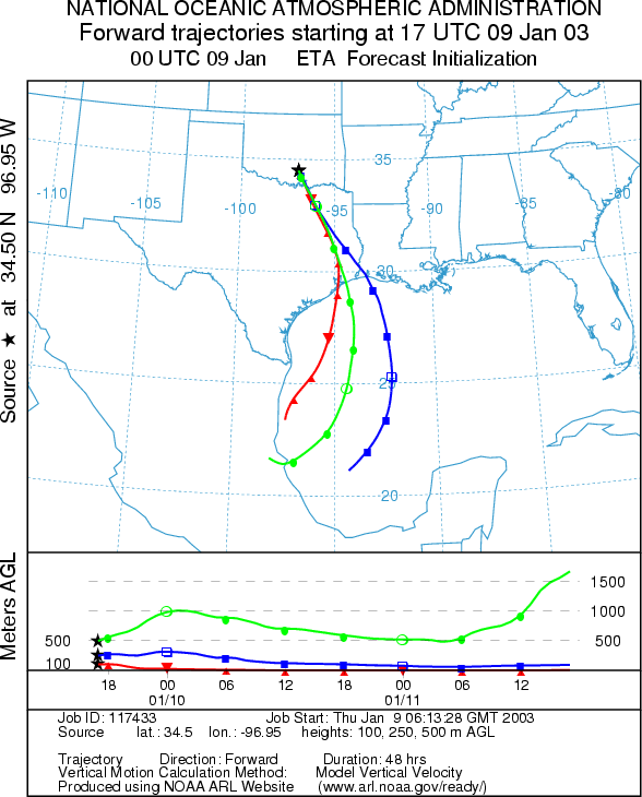
Regional Weather: Thursday, January 9 TX/OK/AR: High pressure will be moving towards the east and one last day of warm conditions will occur before cooler weather moves into the region. Skies today will be partly cloudy to the north in Oklahoma and to the south in southern Texas. Cold air is beginning to push into the area and will continue throughout the day eventually affecting the trajectories across the region. High temperatures across the southern area of the Edwards Plateau will reach the upper 70s today with partly sunny skies and low humidity. Winds will be light tonight but increase to moderate to strong conditions from south to north. Low temperatures overnight will be from the mid 30s to mid 40s. On Friday, cooler temperatures will begin to work their way into the area dropping temperatures by 10 to 15 degrees across the area. Winds on Friday will slacken to moderate conditions across the region. In Oklahoma, cooler conditions will arrive today with partly cloudy skies and strong winds from the north. Temperatures will only reach the mid to lower 50s across the region. Temperatures overnight will be well below freezing in the mid 20s and then rise by less than 10 degrees for highs on Friday. Winds will relax on Friday from strong to moderate strength out of the north.
Trajectory weather: The air mass trajectories from the Arbuckle Mountains move to the south to southeast on moderate to strong winds under the influence of the cold air draining from the north into the region. The trajectories show poor characteristics for entrainment and travel of pollen downwind. Unlike the eastern trajectory in Texas, the atmosphere is heavy and moves along the ground, therefore particles that become entrained will move downwind at or near ground levels where it is easier to be filtered out by vegetation. Skies will be partly cloudy with low relative humidity levels and moderate to strong winds from the north. High temperatures today will be in the mid 50s. Overnight temperatures will dip below freezing and then only reach the mid 40s on Friday.
OUTLOOK: *** Moderate Threat Today *** Mixed Conditions for Pollen release. Partly cloudy skies but dry conditions, with temperatures in the mid 50s and strong winds from the north today will result in mixed conditions for pollen release within the Arbuckle Mountain population. Sinking atmospheric conditions today will move any entrained pollen away from the source towards east of Dallas in north Texas. The trajectories show poor characteristics associated for entrainment and travel. However, if pollen is released and entrained significant amounts may be deposited downwind but relatively close to the source. The trees should be prime for release and with the mild conditions yesterday and only the beginning of the cool down occurring today, therefore some pollen may be available for release. Therefore a moderate threat is forecast today with the possibilities of some pollen moving away from the source towards northeastern Texas and possibly if there is a wind shift edging into the eastern Dallas/Ft. Worth urban areas.
Trajectory Start (s) (shown by black star on map): Sulfur, OK.
Prepared by: Peter
K. Van de Water (Department of Geosciences,
Questions: Aerobiology Lab e-mail: pollen@utulsa.edu
Return to Forecasting Home Page