The
Mountain
Cedar Pollen Forecast
Metropolitan Area |
Exposure Risk |
|
|
Low/ Low |
|
Tulsa |
Low/ Low |
|
|
Low/ Low |
Date Issued:
Mountain Cedar Location(s):
Regional Weather: Saturday,
January 11 and Sunday, January 12 TX/OK/AR: Winter returns this weekend as cold air and rain showers are expected across the
region. Partly
cloudy to cloudy conditions will occur across south Texas as a weather system fuels rain showers across the southern
Texas region spreading northward into eastern Texas.
High temperatures will just make it into the low 50s with moderate winds
from the southeast. Overnight
temperatures will be in the mid 30s to mid 40s with cloudy conditions and high relative humidity with a chance
of showers from Dallas southward. On Sunday conditions begin to improve but cloudy conditions will be the rule across
the region with a chance of showers developing towards the south again.
High temperatures will range from the low to upper 50s across the region
and humidity will be relatively high. In Oklahoma conditions on Saturday will be cloudy and cold as well but with sun breaks
and potentially mostly sunny skies to the north.
Temperatures will be cold with highs expected in the mid 40s today and
near or below freezing tonight. Winds will be moderate and from the southeast.
Overnight clear skies will give way to mostly cloudy conditions with
the high temperatures in the mid to upper 40s on Sunday.
Some showers may leak northward out of Texas into southern Oklahoma
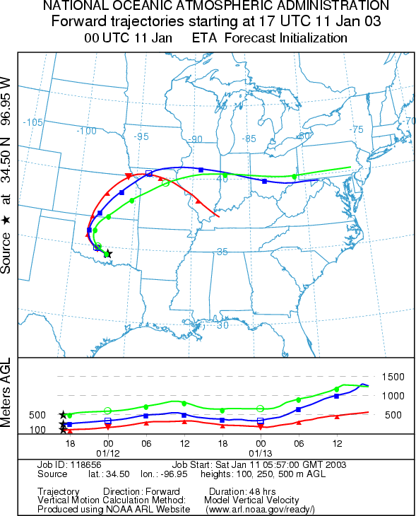
Trajectory weather: The air mass trajectories from the Arbuckle Mountains move northeastward over Oklahoma and across Missouri. The trajectories show good characteristics for entrainment and travel with relatively stable atmospheric conditions. However, cloudy skies and cold temperatures will prevail at the source site with high temperatures only reaching the upper 40s today. Moderate winds from the southeast and high humidity are on tap for today as well. Overnight cloudy skies will build with temperatures near freezing. Sunday: Similar conditions will occur with mostly cloudy conditions and temperatures barely reaching 50 late in the afternoon. There is a possibility of showers developing to the south that may leak northward into southern Oklahoma. The trajectories show movement along a similar pathway as Saturday crossing northeastern Oklahoma and into Missouri. Trajectory characteristics are good for pollen entrainment and travel but little release is expected at the source site.
OUTLOOK: Saturday: ***Low Threat today***Unfavorable Conditions for Pollen release. Sunday: *** Low Threat today***Unfavorable
Conditions for Pollen release. Conditions in the
Trajectory Start (s) (shown by black star on map): Sulfur, OK.
Prepared by: Peter
K. Van de Water (Department of Geosciences,
Questions: Aerobiology Lab e-mail: pollen@utulsa.edu
Return to Forecasting Home Page