The
Mountain
Cedar Pollen Forecast
Metropolitan Area |
Exposure Risk |
|
|
Low |
|
|
Low |
|
|
Low |
Date Issued:
Mountain Cedar Location(s):
Regional Weather: Friday, January 13 TX/OK/AR: High pressure will build over central Texas today as the weather system that affected the area over the weekend moves to the east. Across the region cloudy conditions with high humidity will occur this morning breaking into sunny but cool conditions this afternoon. This is especially true in western Texas compared to eastern areas. Temperatures will be in the low to mid 50s in areas that maintain the cloudiness whereas to the west the upper 50s can be expected. Humidity will remain high as areas begin to dry out from the showers over the weekend. Region wide winds will be from the southwest and light. Low temperatures overnight will be in the upper 30s to low 40s with warmer sunny conditions expected region wide on Tuesday. High temperatures on Tuesday will return to the mid to low 60s region wide. In Oklahoma, partly cloudy skies and temperatures in the low 50s will occur today, with heightened relative humidity and light winds from the southwest. Overnight low temperatures will be in the mid 30s with light winds. On Tuesday, conditions will improve to the south with sunny skies and warmer conditions. Highs on Tuesday will be in the upper 50s and dryer than today.
Trajectory weather: The air mass trajectories from eastern Edwards Plateau of Texas move to the north to northeast over the Edwards Plateau, the Dallas/Ft. Worth area and into Oklahoma. The trajectories show stable to sinking atmospheric conditions along the trajectory pathways as they move out of the region. Weather conditions will be decent in the southern Edwards Plateau source areas, with temperatures in the 50s but high humidity and partly to mostly cloudy conditions to the east should dampen the potential for release. Conditions at the source sites will be warmer and dryer tomorrow with high temperatures in the mid 60s across the area. Overnight low temperatures will drop into the mid 30s to lower 40s. Winds will continue to be light from the southwest.
OUTLOOK: *** Low Threat today ***Unfavorable to Mixed Conditions for Pollen Release Today. Cloudy skies and high relative humidity along with cool temperatures with only light winds result in unfavorable to mixed conditions for pollen release region wide. If pollen release is going to occur it is expected from the western populations where conditions will improve faster than to the east. The trees are near their peak release period so pollen release cannot be ruled out. However with the weather that the area saw over the weekend, the trees may respond better to the warm up on Tuesday. Trajectory characteristics from each of the selected source sites on the Edwards Plateau show stable to sinking atmospheric conditions that are not great for entrainment and travel. If pollen release occurs in the western populations light winds should be able to entrain a limited amount and move it northward towards the Dallas/Ft. Worth area and regions to the west. With unfavorable to mixed conditions for release and moderate to poor atmospheric characteristics a low threat for entrainment and travel exists.
Trajectory Start (s)
(shown by *
on map):
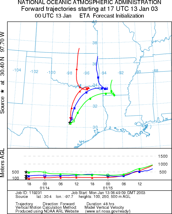
Junction, TX

Prepared by: Peter
K. Van de Water (Department of Geoscience,
Questions: Aerobiology Lab e-mail: pollen@utulsa.edu
Return to Forecasting Home Page