The
Mountain
Cedar Pollen Forecast
Metropolitan Area |
Exposure Risk |
|
|
Moderate |
|
|
Moderate |
|
|
Moderate |
Date Issued:
Mountain Cedar Location(s):
Regional Weather: Friday, January 14 TX/OK/AR: High pressure will be in control over southern Texas today as a cold front starts to push southward and a significant winter storm begins to build to the west that will affect northern areas of the forecast region on Wednesday and Thursday. In Texas today sunny skies and warm temperatures with low humidity will occur region wide as high pressure centered over southeastern Texas dominates the weather pattern. Temperatures will be in the low to mid 60s across the region with sunny to mostly sunny skies and low levels of humidity, especially to the west. Region wide winds will be from the south to southwest and light. Low temperatures overnight will be in the upper 30s to mid 40s with warmer and sunny conditions returning to southern Texas on Wednesday. Partly cloudy skies will prevail in northern Texas on Wednesday, temperatures will be in the mid 60s but conditions should be windy from the south to southeast. In Oklahoma, partly cloudy skies and temperatures in the mid 50s will occur today, with moderate relative humidity and light winds from the northeast. Overnight low temperatures will be in the mid 30s with light winds. On Wednesday, conditions will begin to deteriorate as a winter weather system moves out of the Rocky Mountains into Kansas and northern Oklahoma. Wednesday evening into Thursday conditions continue to deteriorate as winter weather conditions continue in eastern Oklahoma, Arkansas and eastern Texas.
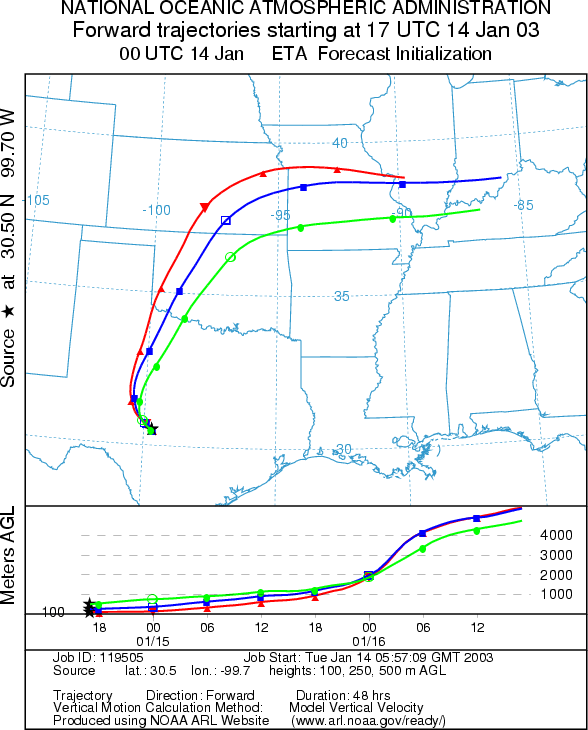
Trajectory weather: The air mass trajectories from eastern Edwards Plateau of Texas move to the north to northwest over the Edwards Plateau, the Dallas/Ft. Worth area and into central to western Oklahoma. They then proceed on into Kansas and loop to the east over northern Missouri. The trajectories show rising atmospheric conditions along the trajectory pathways as they move out of the region. Weather conditions will be warm with low humidity and sunny skies in the southern source areas indicating good conditions for pollen release. Winds will continue to be light to moderate presenting overall conditions that should lead to entrainment and travel of pollen downwind.
OUTLOOK: *** Moderate Threat today ***Mixed Conditions for Pollen Release Today. Clearing skies, decreasing humidity along with warm temperatures with only light winds result in mixed conditions for pollen release region wide. Trajectory characteristics from each of the selected source sites on the Edwards Plateau show rising atmospheric conditions that are characteristic for the entrainment and travel of pollen downwind. The pathway of the trajectories puts the communities of Dallas/Ft. Worth, Oklahoma City and areas of western Oklahoma at moderate risk for some pollen. Further north cloudy conditions and higher humidity should cause deposition and a cleansing of the atmosphere. With the possibility of some pollen release and characteristics of the trajectories that have in the past lead to significant amounts of pollen being transported downwind a moderate threat for entrainment and travel exists.
Trajectory Start (s)
(shown by *
on map):
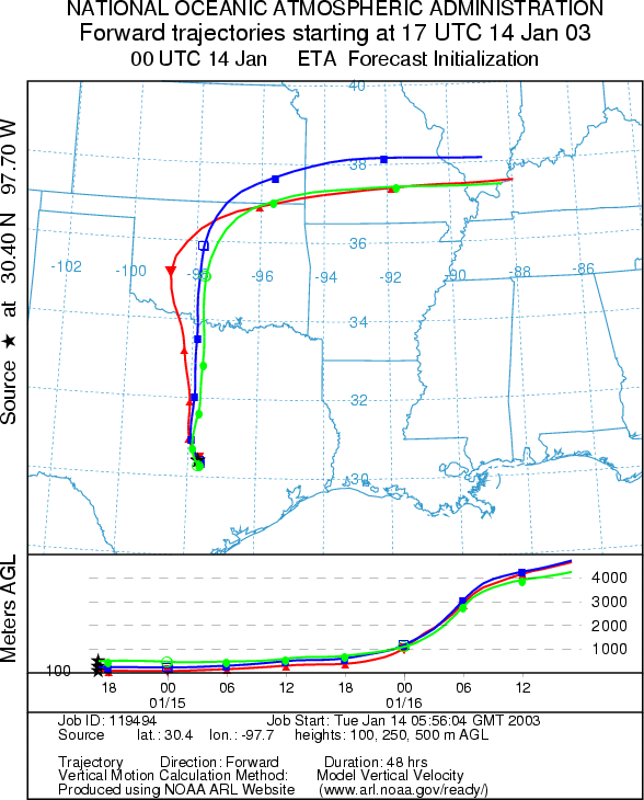
Junction, TX
Prepared by: Peter
K. Van de Water (Department of Geoscience,
Questions: Aerobiology Lab e-mail: pollen@utulsa.edu
Return to Forecasting Home Page