The
Mountain
Cedar Pollen Forecast
Date Issued:
Mountain Cedar Location(s):
Regional Weather: Friday, January 14 TX/OK/AR: High pressure will be in control over southern Texas today as a cold front starts to push southward and a significant winter storm begins to build to the west that will affect northern areas of the forecast region on Wednesday and Thursday. In Texas today sunny skies and warm temperatures with low humidity will occur region wide as high pressure centered over southeastern Texas dominates the weather pattern. Temperatures will be in the low to mid 60s across the region with sunny to mostly sunny skies and low levels of humidity, especially to the west. Region wide winds will be from the south to southwest and light. Low temperatures overnight will be in the upper 30s to mid 40s with warmer and sunny conditions returning to southern Texas on Wednesday. Partly cloudy skies will prevail in northern Texas on Wednesday, temperatures will be in the mid 60s but conditions should be windy from the south to southeast. In Oklahoma, partly cloudy skies and temperatures in the mid 50s will occur today, with moderate relative humidity and light winds from the northeast. Overnight low temperatures will be in the mid 30s with light winds. On Wednesday, conditions will begin to deteriorate as a winter weather system moves out of the Rocky Mountains into Kansas and northern Oklahoma. Wednesday evening into Thursday conditions continue to deteriorate as winter weather conditions continue in eastern Oklahoma, Arkansas and eastern Texas.
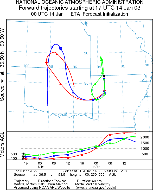
Trajectory weather: The air mass trajectories from
the
OUTLOOK: *** Low Threat Today*** Unfavorable Conditions for Pollen Release. Partly cloudy skies, light winds and cool temperatures will result in unfavorable conditions for pollen release today. The trajectories show good characteristics for pollen entrainment and travel downwind but poor conditions near ground level. If pollen was released it would travel southward towards Little Rock the westward in to central Oklahoma where pollen from Texas and the Arbuckle Mountains is expected to move through earlier. However, the less than ideal conditions at the source site makes the release of pollen unlikely. Because of these poor conditions This coupled with poor climatic conditions a low threat is forecast today.
Trajectory Start (s)
(shown by black star
on map):
Prepared by: Peter K. Van de Water (Department of Geosciences,
Questions: Aerobiology Lab e-mail: pollen@utulsa.edu
Return to Forecasting Home Page