The
Mountain
Cedar Pollen Forecast
Metropolitan Area |
Exposure Risk |
|
|
Low to Moderate |
|
Tulsa |
Low |
|
|
Low |
Date Issued:
Mountain Cedar Location(s):
Regional Weather: Friday, January 14 TX/OK/AR: High pressure will be in control over southern Texas today as a cold front starts to push southward and a significant winter storm begins to build to the west that will affect northern areas of the forecast region on Wednesday and Thursday. In Texas today sunny skies and warm temperatures with low humidity will occur region wide as high pressure centered over southeastern Texas dominates the weather pattern. Temperatures will be in the low to mid 60s across the region with sunny to mostly sunny skies and low levels of humidity, especially to the west. Region wide winds will be from the south to southwest and light. Low temperatures overnight will be in the upper 30s to mid 40s with warmer and sunny conditions returning to southern Texas on Wednesday. Partly cloudy skies will prevail in northern Texas on Wednesday, temperatures will be in the mid 60s but conditions should be windy from the south to southeast. In Oklahoma, partly cloudy skies and temperatures in the mid 50s will occur today, with moderate relative humidity and light winds from the northeast. Overnight low temperatures will be in the mid 30s with light winds. On Wednesday, conditions will begin to deteriorate as a winter weather system moves out of the Rocky Mountains into Kansas and northern Oklahoma. Wednesday evening into Thursday conditions continue to deteriorate as winter weather conditions continue in eastern Oklahoma, Arkansas and eastern Texas.
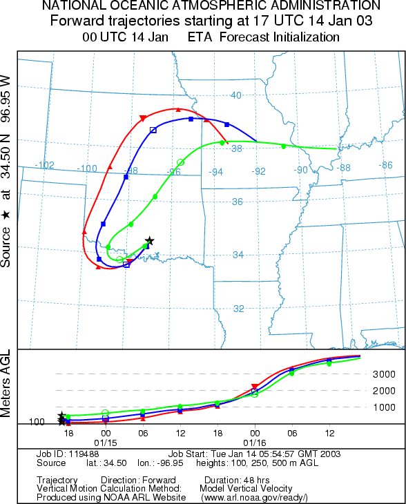
Trajectory weather: The air mass trajectories from the Arbuckle Mountains loop from the site towards the west then move northward through western Oklahoma and into Kansas. The trajectories show good characteristics for entrainment and travel of pollen downwind. In addition, temperatures at the source site will be warm today with the high expected to be close to 60 degrees, low relative humidity and sunny skies. Partly cloudy skies and cooler conditions will occur just to the north as a stationary front sits across central Oklahoma today. Oklahoma City and Tulsa will only reach the mid 50s with winds light to moderate winds from the northeast. Sunny skies today in southern Oklahoma will become partly cloudy overnight and tomorrow with a slight cooling expected on Wednesday.
OUTLOOK: *** Moderate Threat Today *** Mixed Conditions for Pollen release. Clearing skies with dropping humidity, cool temperatures and light winds result in mixed conditions for pollen release within the Arbuckle Mountain population. Atmospheric conditions are good for downwind travel today with the trajectories moving towards the western side of Oklahoma where pollen from Texas (see the Texas forecast) may be moving northward, therefore there is a moderate threat for pollen to the west and north towards the Kansas border. Cloudy conditions further north along with higher humidity should cleanse some of the entrained pollen before it can move through the state of Kansas. Conditions will begin to deteriorate tonight and into tomorrow as a major snowstorm is moving across the Rocky Mountains heading towards the area.
Trajectory Start (s) (shown by black star on map): Sulfur, OK.
Prepared by: Peter
K. Van de Water (Department of Geosciences,
Questions: Aerobiology Lab e-mail: pollen@utulsa.edu
Return to Forecasting Home Page