The
Mountain
Cedar Pollen Forecast
Metropolitan Area |
Exposure Risk |
|
|
Low |
|
|
Low |
|
|
Low |
Date Issued:
Mountain Cedar Location(s):
Regional Weather: Wednesday, January 15 TX/OK/AR: High pressure will be in control this morning centered over northern Louisiana but will slide towards the east to northeast during the day as a major winter storm heads out of the Rocky Mountains into the central plains. The jet stream will move southward and cold air will drain southward lowering temperatures across the region starting this afternoon and into tomorrow. Today, however clear skies but foggy conditions across Texas will be the norm this morning with clouds building towards the west this afternoon and cloudy conditions tonight and into tomorrow. Winds overnight were light from the south to southeast bringing moisture up from the Gulf of Mexico, with a continued flow from the south to southeast the rest of the day but at moderate strength. In Texas, foggy conditions are expected to lift by mid-morning to early afternoon depending on the location but humidity will remain relatively high, above 50% in most areas. Temperatures may reach seasonal normals with the mid 60s to the south and mid 50s to the north. Areas to the west will be drier, but clouds will build in this afternoon sooner than towards the east. Low temperatures overnight will be in the mid to upper 40s with similar conditions or even lower temperatures as highs during the day on Thursday. Cloudy skies will prevail in Oklahoma, with high temperatures today in the low to mid 40s and increasing humidity as the winter weather passes just to the north. How far south the storm track sags will determine if there will be significant snowfall in the area. Early forecasts showed Tulsa and northeastern Oklahoma getting snow showers overnight and into tomorrow. Temperatures overnight will be in the mid 30s to below freezing from south to north with little change for high temperatures on Thursday. Moderate winds today from the southeast will switch to a northerly flow with conditions becoming strong overnight and into tomorrow.
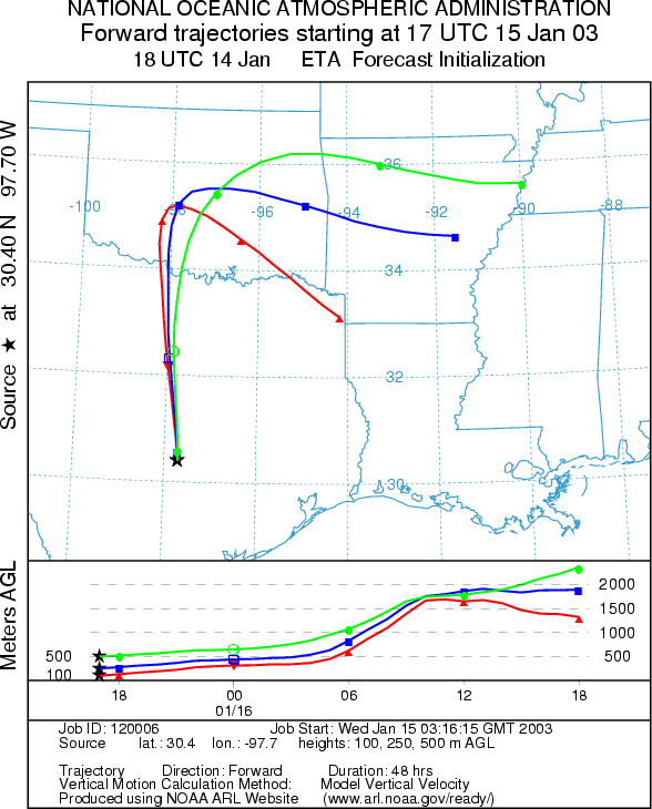
Trajectory weather: The air mass trajectories from the Edwards Plateau in Texas all move towards the north then are carried towards the east and eventually southeast over Oklahoma. The trajectories show rising atmospheric conditions along the trajectory pathways as they move out of the region with buoyant conditions that is good for the entrainment and travel of pollen. However, temperatures to the south may reach the lower 60s depending on clearing of the fog, but high humidity and increasing cloudiness from the west make for less than ideal conditions. Winds will continue to be light to moderate from the south to southeast today and into tonight.
OUTLOOK: *** Low Threat today ***Mixed Conditions for Pollen Release Today. Skies are overcast across the region this morning with foggy conditions, but will clear in parts of the Plateau this afternoon. As a result, mixed conditions for pollen release region wide are forecast today. Trajectory characteristics from each of the selected source sites on the Edwards Plateau show rising atmospheric conditions that are characteristic for the entrainment and travel of pollen downwind. The pathway of the trajectories puts the communities of Dallas/Ft. Worth and Oklahoma City at risk for pollen deposition. However, conditions similar to these earlier in the year have not lead to any significant release and therefore the threat for significant amounts of pollen traveling over these communities today is judged to be low today. The trajectories all move toward cloudier conditions, with colder temperatures and higher humidity, which also plays into a reduction of the threat to downwind communities.
Trajectory Start (s)
(shown by *
on map):
Junction, TX
Prepared by: Peter
K. Van de Water (Department of Geoscience,
Questions: Aerobiology Lab e-mail: pollen@utulsa.edu
Return to Forecasting Home Page