The
Mountain
Cedar Pollen Forecast
Metropolitan Area |
Exposure Risk |
|
|
Low |
|
|
Low to Moderate |
|
|
Low to Moderate |
Date Issued:
Mountain Cedar Location(s):
Regional Weather: Thursday, January 16 TX/OK/AR: A winter storm will move across the Central Plains today bringing very windy conditions and cold temperatures to the region. The Storm moved out of the Rocky Mountains overnight and into Kansas and Missouri bring snowfall to a wide region. Northeastern Oklahoma and northern Arkansas can expect to see some snow flurries this morning. To the south partly cloudy conditions, cold temperatures and very windy conditions will occur across southern Oklahoma and central Texas. Winds will be from the north to northwest and above 20 miles per hour from Tulsa south to Austin Texas. High temperatures today will range from the upper 20s in the Ozark Mountain region to the mid 30s in southern Oklahoma the 40s in the hill country of the Edwards Plateau and to the low 50s along the southern edge of the Plateau in Austin and San Antonio. Relative humidity will be low as this cold dry air from the north dries the region out. Overnight skies will clear and below freezing conditions can be expected across the entire region with lows in the lower teens to the north and low 30s to upper 20s to the south. Temperatures will begin to warm on Friday as the current weather system moves into the southeast and eventually up the eastern seaboard.
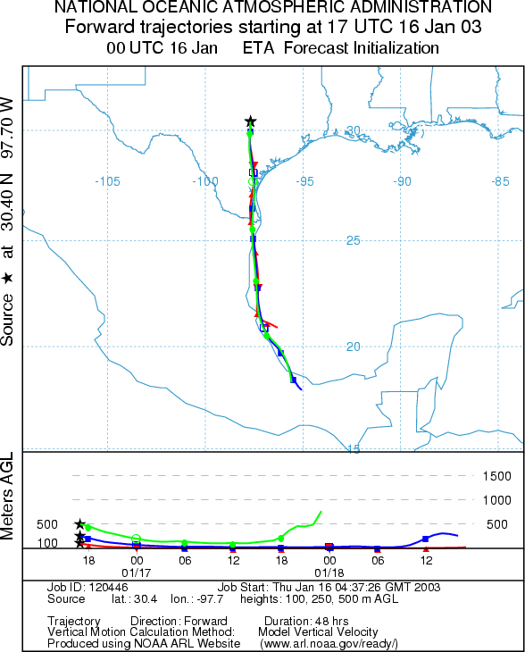
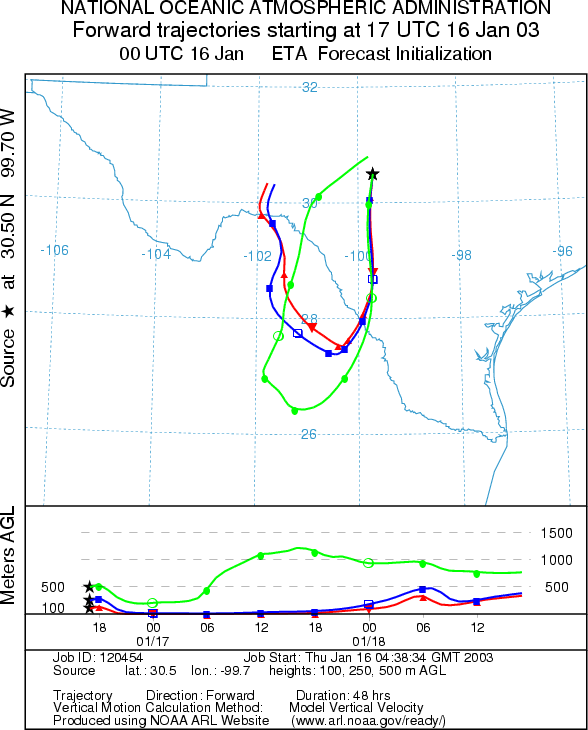
Trajectory weather: The air mass trajectories from the Texas sites all move southward with the dominant winds coming from the north. The trajectories from the western side of the Edwards Plateau will turn back towards the north over Mexico overnight. The trajectories show sinking atmospheric conditions as heavy cold air from the north drains into the region. Atmospheric characteristics are not good for the entrainment and travel of pollen. In addition, temperatures across the region will be cold today and especially overnight with partly cloudy skies. Winds will be strong with sustained levels above 20 miles per hour in most areas.
OUTLOOK: *** Low to Moderate Threat today ***Mixed Conditions for Pollen Release Today. Borderline temperatures lead to a forecast that is generally unfavorable for pollen release; however limited release may occur especially in protected areas. Trajectory characteristics from each of the selected source sites on the Edwards Plateau show sinking atmospheric conditions that are not good for the entrainment and travel of pollen downwind. The pathway of the trajectories all drop to the south under the influence of strong northerly winds. For these reasons a low threat for downwind dispersal of pollen is forecast.
Trajectory Start (s)
(shown by *
on map):
Junction, TX
Prepared by: Peter
K. Van de Water (Department of Geoscience,
Questions: Aerobiology Lab e-mail: pollen@utulsa.edu
Return to Forecasting Home Page