The
Mountain
Cedar Pollen Forecast
Metropolitan Area |
Exposure Risk |
|
|
Low |
|
|
Low |
|
|
Low |
Date Issued:
Mountain Cedar Location(s):
Regional Weather: Friday, January 17 TX/OK/AR: A ridge of high pressure has built in after the winter storm moved towards the east bringing calm but cold conditions overnight. Temperatures across the region were frigid with readings in the lower teens to the north into the lower 30s to the south. Sunny to mostly sunny conditions are in store for the entire region today, but conditions will continue to be cold. However, warmer conditions are on their way for the weekend as temperatures rebound into the upper 50s and low 60s by Sunday. In Texas today, sunny to mostly sunny skies are in store but with high temperatures being from the mid 40s in the north to just over 50 degrees in the south. Winds will be light to moderate and from the north in most areas but southerly breezes will occur along the western side of the Edwards Plateau. Tonight temperatures will again be below freezing across the region then a 4 to 5 degree warm up is expected on Saturday. In Oklahoma, temperatures will be very cold as most locations will struggle to get to the upper 30s today. Winds will be light to moderate from the north and sunny skies will prevail. Temperatures overnight will be in the mid 20s with a 4 to 5 degree warm-up in store for Saturday. Winds will become moderate to strong and from the north to northwest on Saturday.
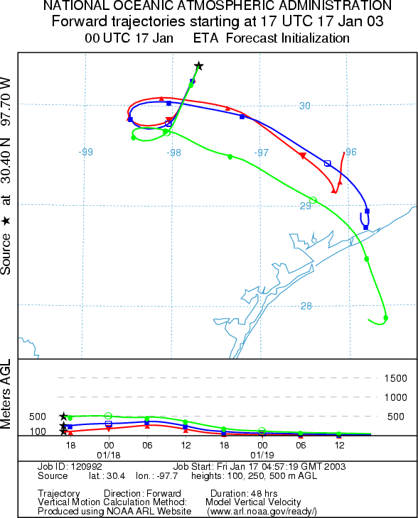
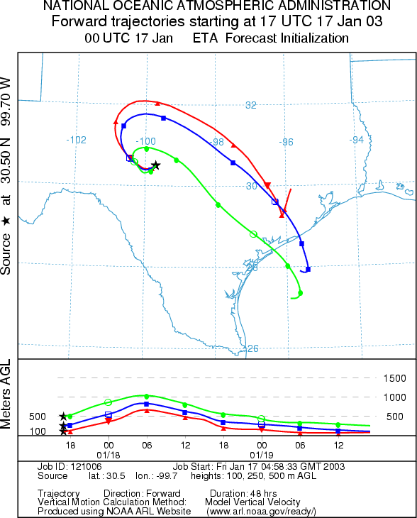
Trajectory weather: The air mass trajectories from the Texas sites all show localized movement over the next 48 hours staying within the state. Along the western side of the Edwards Plateau the trajectories move to the northwest initially then loop back towards the southeast. To the east the trajectories move towards the southwest then loop back eventually moving southeasterly towards the Gulf of Mexico. The trajectory characteristics show relatively buoyant atmospheric conditions to begin with but then the atmosphere begins to sink and move at ground level. Temperatures across the region will be cold today with highs only in the mid 40s in most places. Below freezing temperatures are expected overnight in most areas. Winds will be light to moderate overnight from the south to southwest, switching to a westerly flow tomorrow.
OUTLOOK: *** Low Threat today ***Unfavorable Conditions for Pollen Release Today. Clear skies this morning with low humidity but very cold temperatures overnight and during the day today lead to a forecast of unfavorable conditions for pollen release. Trajectory characteristics from the source sites on the Edwards Plateau show initial buoyant atmospheric conditions starting to sink with the cool down overnight. Conditions are appropriate to expect entrainment and travel during the day but turn to poor conditions for the entrainment and travel of pollen downwind late today and overnight. Because the conditions are so cold little pollen release is expected therefore a low threat for pollen dispersal downwind is forecast.
Trajectory Start (s)
(shown by *
on map):
Junction, TX
Prepared by: Peter
K. Van de Water (Department of Geoscience,
Questions: Aerobiology Lab e-mail: pollen@utulsa.edu
Return to Forecasting Home Page