The
Mountain
Cedar Pollen Forecast
Metropolitan Area |
Exposure Risk |
|
|
Low/ Low |
|
Tulsa |
Low/ Moderate |
|
|
Low/ Moderate |
Date Issued:
Mountain Cedar Location(s):
Regional Weather: Saturday,
January 18 and Sunday, January 19 TX/OK/AR: High pressure has moved in across the region but with cold temperatures only beginning
to moderate. Clear
skies will occur over much of Texas today and tomorrow.
Today winds from the north to northwest will be moderate to strong from
southern to northern Texas. The
current jet stream is positioned over southern Oklahoma and Northern Texas so those areas will see very windy conditions
today and moderately gusty conditions tomorrow.
Wind direction will shift tomorrow coming from the west to southwest. Temperatures
across Texas will remain cold today with regional conditions below the mid 50s and northern Texas only reaching
the high 40s. Tomorrow
will be warmer as high temperatures rebound by 5 to 10 degrees depending on your location.
The cold air is also dry resulting in low relative humidity conditions
both days. Overnight
low temperatures will be in the 30s with below freezing conditions on the Plateau and to the west. In Oklahoma,
a weather system is building over the Ozark Mountains but will move to the east during the day.
There is a slight possibility for some backside precipitation in eastern
Oklahoma. Temperatures
will be cold today with highs only in the 40s and lows tonight well below freezing.
Winds will be moderate to strong today and tomorrow from the northwest
switching to a southwesterly flow overnight and into tomorrow.
Sunny and clear skies will occur in southern Oklahoma with partly cloudy skies both days
to in northeastern Oklahoma and over the Ozark Mountains.
As in Texas temperatures will ameliorate on Sunday with a 5 to 10 degree
or greater warm-up during the two periods.
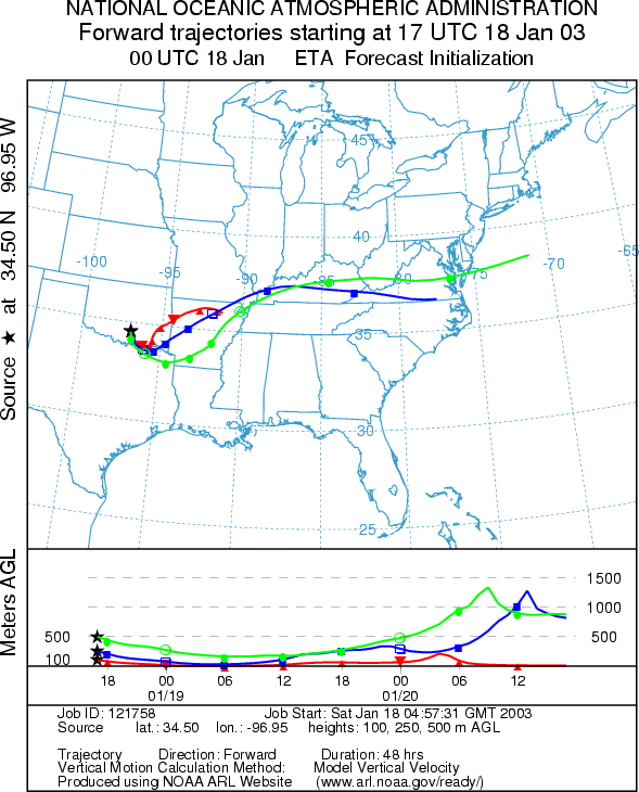
Trajectory weather: The air mass trajectories from the Arbuckle Mountains move eastward along the Oklahoma and Texas border then northeast across Arkansas and into the Ohio River valley. The trajectories show poor characteristics for entrainment and travel with sinking atmospheric conditions. Clear skies but cold temperatures will prevail at the source site with high temperatures reaching the mid to low 40s today. Moderate to strong winds from the west to northwest are on tap for today as well. Overnight clear skies will drop temperatures just below freezing. Sunday: Sunny skies will prevail with dry conditions and moderate winds from the west to northwest. High temperatures will be in the low 50s. The trajectories show movement to the northeast across northeastern Oklahoma, central Missouri and points eastward. Trajectory characteristics are good for pollen entrainment and travel but only mixed conditions for release is expected at the source site.
OUTLOOK: Saturday: ***Low to Moderate Threat today***Mixed Conditions for Pollen release. Sunday: *** Moderate Threat today***Mixed
to Favorable Conditions for Pollen
release. Conditions in the
Trajectory Start (s) (shown by black star on map): Sulfur, OK.
Prepared by: Peter
K. Van de Water (Department of Geosciences,
Questions: Aerobiology Lab e-mail: pollen@utulsa.edu
Return to Forecasting Home Page