The
Mountain
Cedar Pollen Forecast
Metropolitan Area |
Exposure Risk |
|
|
Low |
|
|
Low |
|
|
Low |
Date Issued:
Mountain Cedar Location(s):
Regional Weather: Thursday, January 23 TX/OK/AR: Conditions across the forecast region will be influenced by the current push of arctic air coming from the north. Partly cloudy to mostlycloudy conditions will occur across the region today with cold temperatures as far south as San Antonio, Texas. Todays highs will be in the low 30s around Dallas to the low 40s on the southern edge of the Edwards Plateau. Winds will be from the north to northeast and light and moderate resulting in even colder wind chill conditions. Skies will be partly cloudy to cloudy over the region. Overnight temperatures will get cold with lows on the Plateau in the mid 20s and including locations along the southern edge of the Edwards Plateau. Similar conditions will return on Friday, with some little amelioration of conditions expected. To the north in Oklahoma high temperatures today will stay in the 20s with cloudy conditions and moderate winds out of the north to northeast. Temperatures overnight will dip into the teens then return to similarly chilly conditions on Friday.
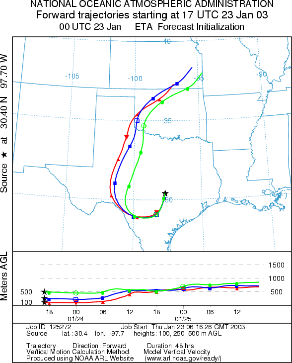
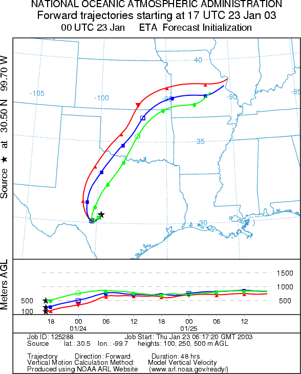
Trajectory weather: The air mass trajectories from the Texas sites show initial movement looping from an original southern direction to the northeast. Atmospheric conditions are good as the trajectories all show buoyant conditions. The trajectories show good conditions for entrainment and travel over the next 48 hours. However, temperatures across the region will be cold with highs expected only in the 40s today. Winds will be light to moderate from the north to northeast. The skies will be cloudy across the region. Overnight temperatures will be in the teens and low twenties resulting in a hard freeze for most regions of the Plateau. Similar conditions will return on Friday with cold temperatures and moderate winds continuing from the north to northeast.
OUTLOOK: *** Low Threat today ***Unfavorable Conditions for Pollen Release Today. Partly cloudy skies today with cold temperatures across the region will result in unfavorable conditions for pollen release today. High temperatures will be in the mid 30s in north Texas and barely reaching into the 40s along the southern Edwards Plateau. In addition, we are nearing the end of the pollination season and the amount of pollen to be dispersed is declining. Recent good conditions did not lead to significant amounts of pollen being reported which leads us to believe that the amount of unopened cones in the populations is small. Trajectory characteristics from the source sites on the Edwards Plateau show good conditions for entrainment and travel. However with the lack of pollen available for entrainment a low threat to downwind communities exists today. Conditions are not expected to improve tomorrow.
Trajectory Start (s)
(shown by *
on map):
Junction, TX
Prepared by: Peter
K. Van de Water (Department of Geoscience,
Questions: Aerobiology Lab e-mail: pollen@utulsa.edu
Return to Forecasting Home Page