The
Mountain
Cedar Pollen Forecast
Metropolitan Area |
Exposure Risk |
|
|
Low to Moderate |
|
|
Low |
|
|
Low |
Date Issued:
Mountain Cedar Location(s):
Regional Weather: Tuesday, January 28 TX/OK/AR: Warm conditions will exist across the region as pressure resides off to the east. Moisture will build throughout the region today and many areas will see thick fog this morning. The Jet stream will become active bringing clouds into the region with most locations being partly to mostly cloudy today tonight and into tomorrow. Warm temperatures are expected region wide. In Texas temperatures will warm up from mild conditions overnight into the upper 50s by noon and into the upper 60s by this afternoon. Skies will be mostly cloudy to mostly today with fog along the eastern edge of the Edwards Plateau and the chance of drizzle in some areas. Moderate to strong winds from the south to southwest will occur this afternoon as the jet stream becomes more active. Overnight temperatures will be in the mid to upper 40s and low 50s with partly cloudy to mostly cloudy skies. Winds will switch to a primarily northerly direction and be moderate. On Wednesday, temperatures will cool 5 to 10 degrees and the humidity will decrease with the dryer northerly breezes .To the north in Oklahoma high temperatures today will be in the 60s across the region. Some areas may awake to fog this morning. Partly cloudy skies with moderate humidity readings are expected. Winds will be moderate to strong from the south to southwest. Overnight winds will switch coming out of the north at moderate levels. Temperatures will return to the upper 30s with partly cloudy skies. On Wednesday, conditions will cool be 10 to 15 degrees with moderate winds from the north and partly cloudy skies. Humidity will be moderate to high across the region Winds will maintain moderate strength coming from the north.
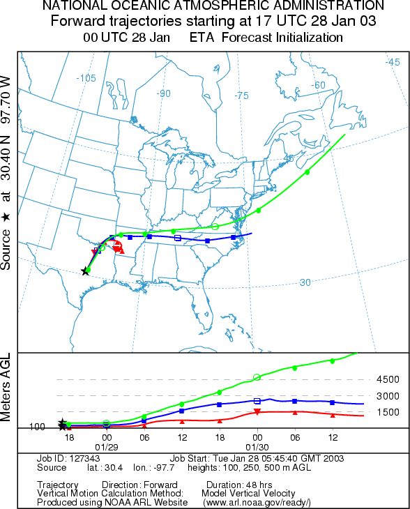
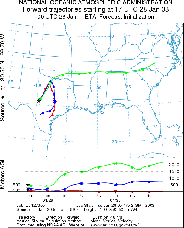
Trajectory weather: The air mass trajectories from the east side of the Edwards Plateau move to the north over northern Texas. The winds travel at ground level for the first 6 hours then become buoyant at the upper levels getting caught in the Jet stream that moves them rapidly to the east. The western trajectories follow a similar pattern with the lowest elevation trajectory turning overnight with the change in winds from the southwest to a northerly direction. The highest elevation winds move rapidly from the area whereas the lower winds move northeast then turn towards the southeast. Temperatures across the region will warm into the upper 60s today but very high humidity make conditions mixed for pollen release from any cones that are left on the trees. Skies will be partly to mostly cloudy and moderate to strong winds from the southwest. Overnight temperatures will only dip into the upper 40s and low 50s but the winds will switch to a northerly direction bringing dryer air to the region.
OUTLOOK: *** Low to Moderate Threat today ***Unfavorable Conditions in the eastern portion of the plateau but Mixed Conditions in the west. Partly cloudy to mostly cloudy skies today with warm temperatures across the region. Eastern parts of the plateau will see fog and mist with a chance of showers during the day. Western parts of the plateau will see clearing this afternoon. High temperatures will be in the upper 60s to low 70s across the region. We may see some pollen release this afternoon in the West. However, all indication are that we are near the end of the pollination season and the amount of pollen to be dispersed is low. Recent good conditions did not lead to significant amounts of pollen being reported which leads us to believe that the amount of unopened cones in the populations is small. Therefore the potential amount of pollen in the atmosphere should not be significant and a low threat exists. Dryer conditions are expected tomorrow with slightly cooler temperatures. With the end of the season near, the Friday (January 31st) forecast will be the last for the season.
Trajectory Start (s)
(shown by *
on map):
Junction, TX
Prepared by: Peter
K. Van de Water (Department of Geoscience,
Questions: Aerobiology Lab e-mail: pollen@utulsa.edu
Return to Forecasting Home Page