The
Mountain
Cedar Pollen Forecast
Date Issued:
Mountain Cedar Location(s):
Regional Weather: Tuesday, January 28 TX/OK/AR: Warm conditions will exist across the region as pressure resides off to the east. Moisture will
build throughout the region today and many areas will see thick fog this morning.
The Jet stream will become active bringing clouds into the region with
most locations being partly to mostly cloudy today tonight and into tomorrow.
Warm temperatures are expected region wide.
In Texas temperatures will warm up from mild conditions overnight into
the upper 50s by noon and into the upper 60s by this afternoon.
Skies will be mostly cloudy to mostly today with fog along the eastern
edge of the Edwards Plateau and the chance of drizzle in some areas.
Moderate to strong winds from the south to southwest will occur this
afternoon as the jet stream becomes more active. Overnight temperatures will be in the mid to upper 40s and low
50s with partly cloudy to mostly cloudy skies.
Winds will switch to a primarily northerly direction and be moderate. On Wednesday,
temperatures will cool 5 to 10 degrees and the humidity will decrease with the dryer northerly breezes .To the
north in Oklahoma high temperatures today will be in the low 60s across the region.
Some areas may awake to fog this morning.
Partly cloudy skies with low to moderate humidity readings are expected. Winds will be
moderate to strong from the south to southwest.
Overnight winds will switch coming out of the north at moderate levels. Temperatures
will return to the upper 30s with partly cloudy skies.
On Wednesday, conditions will cool be 10 to 15 degrees with moderate
winds from the north and partly cloudy skies.
Humidity will be moderate to high across the region Winds will maintain
moderate strength coming from the north.
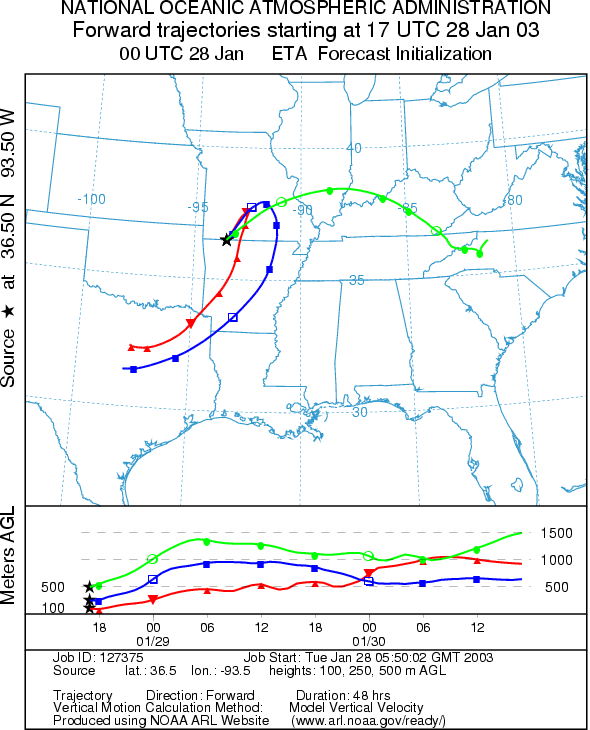
Trajectory Weather: The air mass trajectories from the Ozark Mountains move to the northeast across southern Missouri then the lower trajectories change with a switch in the wind direction and sweep back towards the southwest into eastern Texas. The upper elevation trajectory continues towards the east. Conditions for entrainment and travel are good with buoyant atmospheric conditions. Temperatures across the region will be warm, in the 50s but with cloudy skies and high relative humidity. Winds will be moderate from the south to southwest today switching to a northerly direction overnight. Lows overnight will be near freezing and cool tomorrow by 10 to 15 degrees.
OUTLOOK: *** Low Threat Today*** Unfavorable Conditions for Pollen Release. Warm temperatures but mostly cloudy to cloudy skies, with high humidity levels result in unfavorable conditions for pollen release today. The trajectories show good conditions for entrainment and travel but without a source supply result in a low threat for downwind dispersal. In addition, the trees should be nearing the end of their pollination season so the amount of pollen left to be dispersed is trailing off. Similar conditions are expected tomorrow but with cooler temperatures. . With the end of the season near, the Friday (January 31st) forecast will be the last for the season.
Trajectory Start (s)
(shown by black star
on map):
Prepared by: Peter K. Van de Water (Department of Geosciences,
Questions: Aerobiology Lab e-mail: pollen@utulsa.edu
Return to Forecasting Home Page