The
Mountain
Cedar Pollen Forecast
Date Issued:
Mountain Cedar Location(s):
Regional Weather: Saturday, December 28 and Sunday,
December 29 TX/OK/AR:
Conditions across the southern regions will be under the influence of high pressure as warm, sunny and dry conditions
prevail across the region. In
Texas, mild conditions will continue both days as temperatures will reach the mid to upper 60s both Saturday and
Sunday. The
High pressure to the east will funnel some moisture into the region tomorrow, but skies will remain mostly sunny
to sunny. Winds will be moderate from the southwest throughout the day and overnight but will pick up their intensity
tomorrow afternoon. Southwestern
winds above 25 miles per hour are expected from Oklahoma City to the northern portion of the Edwards Plateau. Humidity
will remain low with zero percent chance of rain over the weekend.
However a significant moisture gradient will occur across the region
on Sunday with humidity expected to be above 50% along the eastern edge and below 50% to the west. Temperatures
overnight will be mild with reading in the mid to upper 40s.
Similar conditions exist to the north with a weekend of sunny warm weather.
Temperatures will reach the upper 50s to low 60s today and tomorrow with nighttime readings around 40. Humidity will
remain low today and tomorrow with winds showing moderate strength gaining in strength tomorrow afternoon.
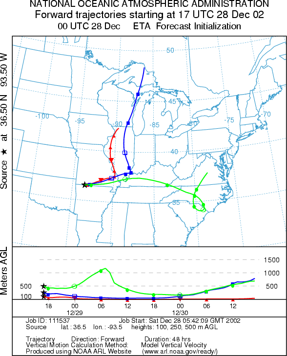
Trajectory weather: The air mass trajectories from
the
OUTLOOK: Saturday***Moderate Threat today*** mixed conditions for pollen release Sunday: *** Severe Threat today*** favorable conditions for pollen release. Warm conditions today and tomorrow with sunny skies moving towards partly cloudy conditions will prevail. Temperatures today will just get into the low 50s and therefore mixed conditions for release are expected. However it has been some time since conditions were even close to being this good therefore significant release may occur in places where the sun warms the area. A moderate threat for entrainment and travel exists today because the trajectory characteristics show little buoyancy in the atmosphere. Tomorrow atmospheric conditions improve with buoyant atmospheric conditions and warm temperatures across the region. Favorable conditions for release are forecast and a severe threat for downwind travel is expected. The communities that may be affected include the St. Louis urban area..
Trajectory Start (s)
(shown by black star
on map):
Prepared by: Peter
K. Van de Water (Department of Geosciences,
Questions: Aerobiology Lab e-mail: pollen@utulsa.edu
Return to Forecasting Home Page