The
Mountain
Cedar Pollen Forecast
Metropolitan Area |
Exposure Risk |
|
|
Low |
|
Tulsa |
Low |
|
|
Low |
Date Issued:
Mountain Cedar Location(s):
Regional Weather: Monday, December 30 TX/OK/AR: Conditions across the southern regions will see the possibility of rain and thunderstorms today as a large low pressure moves across the region. Moisture from the Gulf will clash with colder air moving south from the upper mid-west to cause instability across the region, especially along the southern edge of the Edwards Plateau and along the Gulf Coast into Louisiana. Severe Thunderstorm warnings are posted for the region. Cloudy conditions will occur to the north with the possibility of showers or light rain throughout the region. In Texas temperatures will remain warm with highs in the 60s and low 70s, but with relatively high humidity throughout the day and into the evening. Winds will be moderate from the southwest until the front passes then wind strength will increase to strong shifting to the north to northwest. Clearing will begin tonight from the west with temperatures in the upper 30s to 40s across the region. On Tuesday skies will be sunny with conditions beginning to dry out. To the north conditions will be seasonally warm with high temperatures in the mid- to upper- 50s today, but cloudy skies and the chance of precipitation exists. Winds will be moderate from the south to southwest switching to the northwest overnight. Skies will begin to clear late tonight and into tomorrow with overnight low temperatures in the 30s and tomorrows highs only reaching the mid 50s..
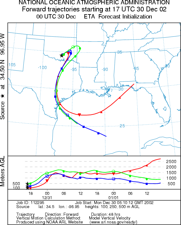
Trajectory weather: The air mass trajectories move from the Arbuckle Mountains to the northeast over southeastern Oklahoma then turn due south and travels over eastern Texas. The trajectories show relatively good characteristics for entrainment and travel of pollen downwind. However, precipitation is expected at the source site reducing the chance of pollen release. Winds will be moderate from the southwest today switching to the northwest overnight with low temperatures in the upper 30s.
OUTLOOK: *** Low Threat today *** unfavorable conditions for pollen release. Conditions today will include a significant chance of rain and cloudy skies keeping the conditions for pollen release unfavorable. Clearing will begin overnight and into tomorrow with sunny skies expected on New Years Eve. Improving conditions are expected tomorrow making conditions for pollen release much better. Poor to mixed atmospheric conditions suggest that if pollen is released limited concentrations will move downwind to the northeast and then south resulting in little chance of impact to any northern area communities. However, with the humid conditions, cloudy skies and chance of precipitation little release is expected therefore a Low threat exists for downwind travel.
Trajectory Start (s) (shown by black star on map): Sulfur, OK.
Prepared by: Peter
K. Van de Water (Department of Geosciences,
Questions: Aerobiology Lab e-mail: pollen@utulsa.edu
Return to Forecasting Home Page