The University of Tulsa
Mountain Cedar Pollen Forecast
Metropolitan Area |
Exposure Risk |
|
Dallas/Fort Worth |
High Threat Friday and Saturday/Moderate on Sunday |
|
Austin |
High Treat |
|
San Antonio |
Moderate to High Threat |
Date Issued: 2 January 2004
Mountain Cedar Location(s): Edwards Plateau, Texas
Regional Weather: Friday, Saturday, and Sunday, Jan 2-4, 2004. TX/OK: Very warm day on Friday with temperatures in the 70s throughout the region. Some areas will see record high temperuatures. Skies will be partly to mostly cloudy with high winds in Oklahoma and moderate winds in Texas. Gulf moisture will keep the humidity high throughout the region with a chance of thuderstorms. On Saturday a cold front will begin to slowly move into the area from the northwest. Temperatures in Oklahoma will begin dropping in the afternoon as winds shift to the west and then north. Skies will be mostly cloudy with continuing chance of rain and thuderstorms. Highs on Saturday should be in the 60s in Oklahoma but will still be in the 70s in Texas with strong southerly winds. Sunday temperatures will be in the 40s to low 50s in Oklahoma with partly cloudy skies and moderately strong north to northwest winds. The cold front will move into Texas on Sunday with winds shifting to the west and then north, northwest late on Sunday. High temperatures will be in the 70s in the south of Texas ahead of the front but highs will be about 10 degrees lower after the front passes.
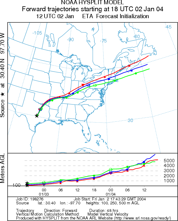
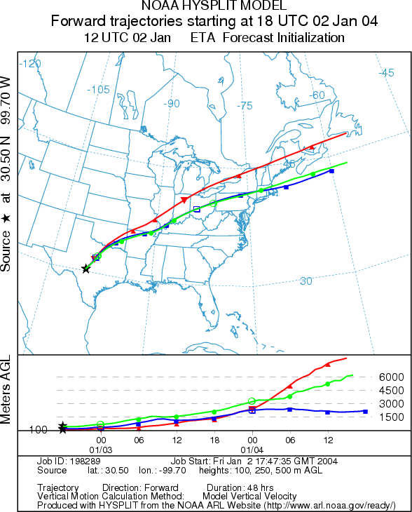
Trajectory weather: The air mass trajectories from Texas move to the northeast on strong southwest winds. The Skies will partly to mostly cloudy across the region with mild temperatures and highs in the 70s. Conditions at the source are warm but humidities are running high this morning. Mild conditions expected to continue overnight and Saturday, but skies will be cloudy with a chance of rain. Trajectories on Saturday continue to show movement to the northeast as winds continue from the southwest for most of the day. Trajectories from the the eastern portion of the Edwards Plateau continue moving northeast; however those from the western portion of the plateau shift around to the south as the cold front moves into west Texas late on Saturday. Winds will change directions on Saturday as the cold front pushes through the state. Trajectories on Sunday initially show movement to the south on moderate northerly winds but circle back around and the cold front moves east. Trajectories show mixed conditions for entrainment and travel.
OUTLOOK: *** High Threat of pollen esposure *** Mostly favorable conditions for pollen release on Friday and Saturday. Warm temperatures,
gusty winds, and partly cloudy skies are good conditions for pollen release, but humidity is high in the region.
Since the trees are near their peak release period significant amounts of pollen release might be expected even
with the high humidity. Temperatures Saturday will continue mild and mostly favorable for pollen release. Atmospheric
conditions for pollen entrainment and travel will deteriorate as the colder heavy air moves across the region at
ground level on Saturday night and Sunday. Any pollen release on Sunday will remain local with a lower threat
of pollen exposure at downwind sites.
Trajectory Start (s) (shown by *
on map): Austin, TX; Junction, TX; San Angelo, TX.
AUSTIN
JUNCTION
SAN ANGELO
Prepared by: Estelle
Levetin (Faculty of Biological
Science, The University
of Tulsa, 600 S. College, Tulsa, OK 74104). This forecast gives the anticipated future track of released
Mountain Cedar pollen, weather conditions over the region and along the forecast pathway, and an estimated time
of arrival for various metropolitan areas.
Questions: Aerobiology Lab e-mail: pollen@utulsa.edu
Return to Forecasting Home Page