The University of Tulsa
Mountain Cedar Pollen Forecast
Metropolitan Area |
Exposure Risk |
|
Oklahoma City |
Mod toHigh Friday/ Low Sat, Sun |
|
Tulsa |
Mod toHigh Friday/ Low Sat, Sun |
|
St. Louis MO |
Low |
Date Issued: 21 Jan 2005
Mountain Cedar Location(s): Arbuckle Mountains, OK
Regional Weather: Fri., Sat., and Sun, Jan 21 to 23.
TX/OK: One more warm day before the next cold front. The leading edge of the cold air will move into northern
Oklahoma Friday evening and quickly spread over the region this weekend. Temperatures on Saturday will fall throughout
the day on brisk northerly winds. The cold front will be short lived as a warm-up begins on Monday. In Oklahoma
on Friday highs will be in the 60s with temperatures dropping into the 30s at night, Highs on Saturday and Sunday
will be in the 30s and low 40s with nighttime lows in the teens and 20s. In Texas, highs on Friday will be in the
70s and lows in the upper 40s and 50s. Highs on Saturday will be in the 50s and 60s with dropping temperatures
during the day and highs on Sunday in the 40s to low 50s. Nighttime lows in Texas on Saturday and Sunday will be
in the 20s to low 30s. Winds will be southerly on Friday with partly to mostly cloudy skies throughout the region.
Satruday will have strong notherly winds throughout the region. Skies will be partly cloudy with a chance of thunderstorms
in central Texas. Winds will start shifting back to the south on Sunday afternoon, especially in Oklahoma. Skies
will be clear to partly cloudy.
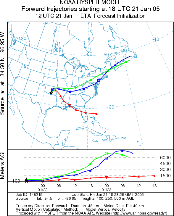
Trajectory weather: The air mass trajectories on Friday move from the Arbuckle Mountains to the north and then east. Partly cloudy skies and warm temperatures at the source. The trajectories on Saturday move to the south over Texas and show poor characteristics for entrainment and travel of pollen downwind as cold air drains into the area. Cold sinking atmospheric conditions results in the air-masses moving along the ground where any entrained particles are quickly filtered. Conditions at the source will be cold on Saturday with falling temperatures. Trajectories on Sunday move to the north as southerly winds return but temperatures at the source will be cold. Sunny skies will prevail across the region but low temperatures and strong gusty winds will occur at the source.
OUTLOOK: *** High Threat Friday/Low on Saturday and Sunday *** Favorable conditions for pollen release
on Friday, unfavorable conditions for Saturday and Sunday. Warm temperatures,
partly cloudy skies and moderate southerly winds will prevail across the source area making for favorable conditions
today. After the cold front moves into the area tonight, conditions will be unfavorable for pollen release for
the remainder of the weekend.
Trajectory Start (s) (shown by black
star on map): Sulfur, OK.
Prepared by: Estelle
Levetin (Faculty of Biological
Science, The University
of Tulsa, 600 S. College, Tulsa, OK 74104). This forecast gives the anticipated future track of released
Mountain Cedar pollen, weather conditions over the region and along the forecast pathway, and an estimated time
of arrival for various metropolitan areas.
Questions: Aerobiology Lab e-mail: pollen@utulsa.edu
Return to Forecasting Home Page