The University of Tulsa
Mountain Cedar Pollen Forecast
Metropolitan Area |
Exposure Risk |
|
Dallas/Fort Worth |
Mod Fri/Low Sat and Sun |
|
Austin |
High Fri/Mod to High Sat/Low Sun |
|
San Antonio |
High Fri/Mod to High Sat/Low Sun |
Date Issued: 21 January 2005
Mountain Cedar Location(s): Edwards Plateau, Texas
Regional Weather: Fri., Sat., and Sun, Jan 21 to 23.
TX/OK: One more warm day before the next cold front. The leading edge of the cold air will move into northern
Oklahoma Friday evening and quickly spread over the region this weekend. Temperatures on Saturday will fall throughout
the day on brisk northerly winds. The cold front will be short lived as a warm-up begins on Monday. In Oklahoma
on Friday highs will be in the 60s with temperatures dropping into the 30s at night, Highs on Saturday and Sunday
will be in the 30s and low 40s with nighttime lows in the teens and 20s. In Texas, highs on Friday will be in the
70s and lows in the upper 40s and 50s. Highs on Saturday will be in the 50s and 60s with dropping temperatures
during the day and highs on Sunday in the 40s to low 50s. Nighttime lows in Texas on Saturday and Sunday will be
in the 20s to low 30s. Winds will be southerly on Friday with partly to mostly cloudy skies throughout the region.
Satruday will have strong notherly winds throughout the region. Skies will be partly cloudy with a chance of thunderstorms
in central Texas. Winds will start shifting back to the south on Sunday afternoon, especially in Oklahoma. Skies
will be clear to partly cloudy.
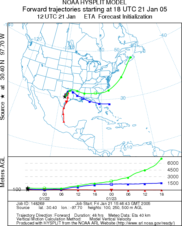
Trajectory weather: The air mass trajectories on Friday
from Edwards Plateau move to the northeast and then turn back around and move to the south as the cold front begins
moving into the area tonight. Conditions across the Plateau will be warm on Friday with moderate southerly winds.
Trajectories on Saturday move to the south on strong northerly winds and those on Sunday move to the north as the
southerly winds return. On Saturday conditions at the source will be favorable for pollen release in some areas
but temperatures will be dropping throughout the day as the cold front moves throught the area. On Sunday temperatures
will be cold across the Plateau.
OUTLOOK: *** High Threat Friday, Moderate
to High Threat Saturday, Low Sunday *** Favorable conditions for pollen release on
Friday, mixed conditions on Saturday and unfavorable on Sunday. Warm temperatures, partly cloudy skies
and moderate southerly winds on Friday across the Plateau should allow for significant pollen release. On Saturday
the cold front will be pushing through Texas dropping temperatures throughout the day. In some areas temperatures
will be favorable for pollen release while in other the conditions will be marginal. In addition there is a chance
of thunderstorms in central Texas on Saturday, resulting in mixed conditions for pollen
release. Low temperatures on Saturday night will limit pollen release on Sunday as afternoon temperatures will
barely reach the favorable range.
Trajectory Start (s) (shown by *
on map): Austin, TX; Junction, TX; San Angelo, TX.
AUSTIN
JUNCTION
SAN ANGELO

Prepared by: Estelle
Levetin (Faculty of Biological
Science, The University
of Tulsa, 600 S. College, Tulsa, OK 74104). This forecast gives the anticipated future track of released
Mountain Cedar pollen, weather conditions over the region and along the forecast pathway, and an estimated time
of arrival for various metropolitan areas.
Questions: Aerobiology Lab e-mail: pollen@utulsa.edu
Return to Forecasting Home Page